Old Maps of Acton, Massachusetts for Genealogy
Trace your family roots with 40 historic maps of Acton. These high-res maps reveal old neighborhoods, homesites, landmarks, and streets — helping you uncover where your ancestors lived and how the area evolved over time.
- Explore historic neighborhoods: Identify where your relatives may have lived in the 1800s or 1900s.
- Compare maps over time: Trace the changes in streets, buildings, and landmarks for multi-generational research.
- Perfect for genealogy & ancestry research: Used by family historians and researchers to map out lineage and migration.
These maps are an incredible resource for exploring your personal connection to Acton's past.
Acton, MA maps
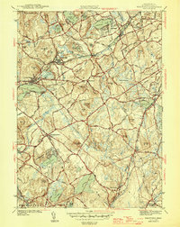
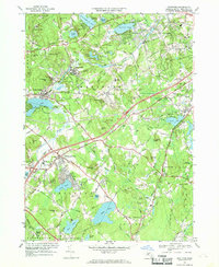
(40)- 1886 Map of Lowell
 1886 Lowell1886 Print · USGSThe industrial heart of the Merrimack Valley is captured here in the late nineteenth century, showing the expansion of textile hubs and rail networks. Genealogists and historians can trace family-named hills and early transit stops like Bedford Springs Station, Forge Village, and the Hudson Poor Farm.
 - 1886 Map of Framingham
 1886 Framingham1886 Print · USGSMiddlesex County emerges as a bustling hub of rail transit and water infrastructure at the close of the 1800s. Genealogists and historians can trace family locations near the Mass. State Muster Grounds, the State Prison, or the historic Wayside Inn.
 - 1889 Map of Framingham
 1889 Framingham1889 Print · USGSThe Framingham and Concord region flourished as a late nineteenth-century rail and industrial hub. Genealogists and historians can trace the early layouts of Saxonville, the American Powder Co., and the Mass. State Muster Grounds.
 - 1893 Map of Lowell
 1893 Lowell1893 Print · USGSThe Merrimack Valley’s industrial and rail landscape comes alive in the late nineteenth century, centering on the growing city of Lowell. Genealogists and historians can trace old property lines across Pelham, locate the Flat Rock Quarry, or follow the routes of the Stony Brook Railroad through Graniteville.9 unique versions available
 - 1894 Map of Framingham
 1894 Framingham1894 Print · USGSMiddlesex County in the late nineteenth century is a landscape of thriving rail depots and literary landmarks. Genealogists and historians can trace the foundations of local life at the Wayside Inn, the State Prison, and the Mass. State Muster Grounds.11 unique versions available
 - 1918 Map of Lowell
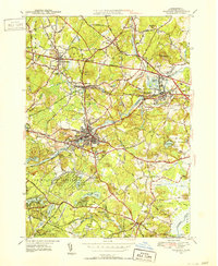
 1918 Lowell1918 Print · USGSGreater Lowell and the Merrimack Valley are shown at their industrial peak during the First World War. Genealogists can trace family connections to mill-town life in Middlesex Village or locate rural landmarks like Flat Rock Quarry and the Old Middlesex Canal.
 - 1918 Map of Framingham
 1918 Framingham1918 Print · USGSEastern Massachusetts is seen here as a bustling rail-and-river corridor during the early twentieth century. Genealogists and historians can trace old property lines and landmarks like the Wayside Inn, the State Prison, and Nine Acre Corner.2 unique versions available
 - 1921 Map of Lowell
 1921 Lowell1921 Print · USGSThe industrial corridor of the Merrimack Valley is captured here during the early twentieth century, showing the dense urban grid of Lowell alongside rural Middlesex County. Researchers can trace the extensive reach of the Boston and Maine Railroad and locate local landmarks like the Poor Farm or Flat Rock Quarry.
 - 1935 Map of Lowell
 1935 Lowell1935 Print · USGSGreater Lowell and the Merrimack Valley are captured in the mid-1930s, showing a region defined by its industrial riverfront and extensive rail networks. Researchers can trace historic neighborhoods like Wamesit, local landmarks like St Marie Convent, and early industry at Flat Rock Quarry.3 unique versions available
 - 1940 Map of Westford
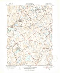
 1940 Westford1940 Print · USGSWestford and Littleton appear at the outbreak of World War II as a network of rail-side mill villages and family-held hills. Genealogists can trace old cemeteries like Westlawn Cem, rural depots at Westford Sta, and the layout of Littleton Common.
 - 1941 Map of Westford
 1941 Westford1941 Print · USGSMiddlesex County in the late 1930s shows a landscape of industrious mill villages and hilltop farms connected by the Boston and Maine line. Trace the rail routes through Graniteville, locate the grounds of Westlawn Cem, or explore the shores of Forge Pond.2 unique versions available
 - 1943 Map of Boston
 1943 Boston1943 Print · USGSGreater Boston and its southern suburbs appear here during the mobilization of the early 1940s. Genealogists and historians can trace the early footprints of Commonwealth Airport, military sites like Fort Winthrop, and local institutions such as Pondville State Hospital.
 - 1943 Map of Maynard
 1943 Maynard1943 Print · USGSMiddlesex County at the height of the Second World War shows a landscape defined by the Assabet River and a thriving rail economy. Genealogists and local historians can trace family plots at Mt Hope Cem or study the grounds of the Concord Reformatory.2 unique versions available
 - 1943 Map of Lowell
 1943 Lowell1943 Print · USGSCentral New England industrial hubs and rural borderlands are mapped here during the early 1940s. Genealogists can trace family names across Mt Misery, Barrett Hill, and small settlements like Collinsville or North Pelham.
 - 1946 Map of Westford
 1946 Westford1946 Print · USGSMiddlesex County in the mid-1940s shows a landscape of busy rail corridors and established villages. Researchers can trace historic family names and sites like Fairview Cem, the Clay Pit, and rail stops at Westford Sta or Carlisle Sta.2 unique versions available
 - 1948 Map of Boston
 1948 Boston1948 Print · USGSEastern Massachusetts and southern New Hampshire appear at an industrial peak in the late 1940s, just as suburban growth began to accelerate. Genealogists and historians can trace rail lines like the Boston and Albany RR or locate coastal landmarks like Graves Lighthouse and Fort Devens.2 unique versions available
 - 1950 Map of Maynard, 1952 Print
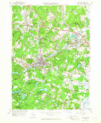
 1950 Maynard1952 Print · USGSMiddlesex County's transition from an industrial river-valley hub to a mid-century residential landscape is visible in this mid-century survey. Trace family roots at St Bridgets Cem, follow the rail lines at West Acton, or locate the extensive U S Military Reservation.4 unique versions available
 - 1950 Map of Westford, 1952 Print
 1950 Westford1952 Print · USGSMiddlesex County in the early fifties shows a region defined by its rail heritage and historic village centers. Trace old family lines through Graniteville, Forge Village, and Littleton Common, or locate ancestral burial sites at Russian Cem and Nutting Cem.4 unique versions available
 - 1956 Map of Boston, 1967 Print
 1956 Boston1967 Print · USGSThe Massachusetts coastline and industrial interior are seen here during the mid-century peak of suburban and highway expansion. Researchers can trace historic harbor defenses like Fort Revere, local landmarks such as Faneuil Hall, and the vast Parker River National Wildlife Refuge.6 unique versions available
 - 1958 Map of Boston
 1958 Boston1958 Print · USGSEastern Massachusetts and southern New Hampshire are shown at the height of the industrial era, before the full expansion of the interstate system. Trace coastal defenses at Fort Warren, historic rail lines like the Boston and Maine, and the development of the Mass. 128 corridor.2 unique versions available
 - 1961 Map of Boston
 1961 Boston1961 Print · USGSThe Massachusetts coastline and its industrial interior are detailed here in the mid-twentieth century, from the Monadnock highlands to Cape Cod. Researchers can trace the rail routes of the Boston and Maine or locate landmarks like Fort Devens and the Wachusett Reservoir.2 unique versions available
 - 1965 Map of Maynard, 1967 Print
 1965 Maynard1967 Print · USGSMid-century Middlesex County highlights a landscape of growing suburbs and deep-rooted industry along the Assabet River. Genealogists and historians can trace the development of Maynard and Sudbury, locating the Concord Reformatory and numerous family-named landmarks like Vose Hill.3 unique versions available
 - 1966 Map of Westford, 1969 Print
 1966 Westford1969 Print · USGSMiddlesex County in the mid-1960s shows a landscape of rail-side industrial villages and expanding school campuses. Genealogists and historians can trace sites like Russian Cem, the Westford Academy, and the old depot at Brookside Station.2 unique versions available
 - 1977 Map of Maynard, 1981 Print
 1977 Maynard1981 Print · USGSMiddlesex County enters the late seventies as a landscape of historic mill towns and growing residential corridors. Trace the development of Maynard and West Concord along the banks of the Assabet River.
 - 1984 Map of Lowell
 1984 Lowell1984 Print · USGSThe Merrimack Valley industrial corridor is captured here in the mid-eighties, showing the interconnected growth of Lowell, Nashua, and Lawrence. Genealogists and historians can trace the paths of the Boston and Maine railroad or locate institutional landmarks like Merrimack College and the Fort Devens Military Reservation.
Showing maps 1-25 of 40
Top cities near Acton
- Lowell historical maps
- Nashua historical maps
- Newton historical maps
- Framingham historical maps
- Waltham historical maps
- Methuen historical maps
See more
Top neighborhoods of Acton
- Village of Nagog Woods historical maps
- East Acton historical maps
- Damons Mills Westvale historical maps
- West Acton historical maps
- South Acton historical maps
- Sidney J. Edward Square historical maps
See more
Frequently asked questions
- What are the different types of historical maps available for Acton?
- What is the oldest map of Acton?
- Where can I purchase historical maps of Acton for my home or office?
- Where can I download high-res historical maps of Acton?
- Are there historical topographic maps available for Acton?
- Is there historical aerial imagery available for Acton?
- Where are historical maps of Acton sourced from?