1960s Maps of Chelmsford, Massachusetts
Explore 6 historic maps of Chelmsford from the 1960s. These maps offer a rare glimpse into what life looked like during the 1960s — showing old roads, neighborhoods, homes, and landmarks that have changed or disappeared over time.
Whether you're researching your family's past, planning a metal detecting trip, or studying how Chelmsford's landscape evolved across the 1960s, these high-resolution maps are a powerful tool for exploring the history of this region.
- Focus on a specific era: All maps on this page are from the 1960s, giving you a focused view of this time period.
- See what’s changed: Compare century-old streets, trails, and buildings to today's modern landscape using overlays and satellite layers.
- Research with precision: Use these maps for genealogy, historical research, land use analysis, or educational projects.
- View, download, or print: Maps are fully viewable online in high resolution, and can be downloaded or printed for your own records.
Start exploring Chelmsford's history through authentic maps from the 1960s. This is your window into the past.
Chelmsford, MA maps
(6)- 1961 Map of Boston
 1961 Boston1961 Print · USGSThe Massachusetts coastline and its industrial interior are detailed here in the mid-twentieth century, from the Monadnock highlands to Cape Cod. Researchers can trace the rail routes of the Boston and Maine or locate landmarks like Fort Devens and the Wachusett Reservoir.2 unique versions available
 - 1965 Map of Nashua South, 1968 Print
 1965 Nashua South1968 Print · USGSThe Merrimack River valley and the expanding outskirts of Nashua come into sharp focus in the mid-sixties. Genealogists and local historians can trace the foundations of Dunstable and Tyngsborough, locating Evergreen Cem and Whidden Corner.7 unique versions available
 - 1965 Map of Billerica, 1968 Print
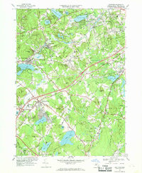
 1965 Billerica1968 Print · USGSMiddlesex County in the mid-1960s shows a landscape of traditional New England town centers being rapidly reshaped by the new interstate highway system. Researchers can trace family roots through numerous burial grounds like Edson Cem or locate community hubs such as Talbot Sch and Nutting Lake.2 unique versions available
 - 1966 Map of Lowell, 1968 Print
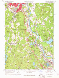
 1966 Lowell1968 Print · USGSMid-century Lowell and Dracut are captured here just as the river-based industry was being joined by suburban expansion and interstate connectors. Genealogists and local historians can trace family sites from the Israel Brotherhood Cem to the Lowell Technological Institute and old Middlesex Village.5 unique versions available
 - 1966 Map of Westford, 1969 Print
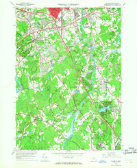
 1966 Westford1969 Print · USGSMiddlesex County in the mid-1960s shows a landscape of rail-side industrial villages and expanding school campuses. Genealogists and historians can trace sites like Russian Cem, the Westford Academy, and the old depot at Brookside Station.2 unique versions available
 - 1969 Map of Lowell, 1988 Print
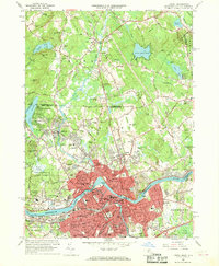
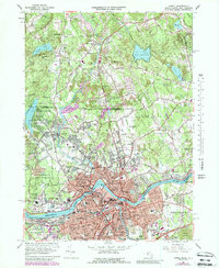 1969 Lowell1988 Print · USGSIn the late sixties, the industrial heart of Lowell and its northern neighbors in Dracut were expanding around the historic Merrimack River. Genealogists and local historians can trace the development of neighborhood schools like Keith Academy and old burial grounds such as St Josephs Cem.
End of results
Showing maps 1-6 of 6
Top cities near Chelmsford
- Boston historical maps
- Lowell historical maps
- Cambridge historical maps
- Nashua historical maps
- Lawrence historical maps
- Somerville historical maps
See more
Top neighborhoods of Chelmsford
- South Chelmsford historical maps
- North Chelmsford historical maps
- Westlands historical maps
- West Chelmsford historical maps
- Ward Corner historical maps
Frequently asked questions
- What are the different types of historical maps available for Chelmsford?
- What is the oldest map of Chelmsford?
- Where can I purchase historical maps of Chelmsford for my home or office?
- Where can I download high-res historical maps of Chelmsford?
- Are there historical topographic maps available for Chelmsford?
- Is there historical aerial imagery available for Chelmsford?
- Where are historical maps of Chelmsford sourced from?