Old Maps of Watertown, Massachusetts for Academic Research
Study the evolution of Watertown with 32 high-resolution historic maps. Whether you're teaching, researching, or modeling changes in land use, these maps provide essential visual documentation of urban, environmental, and geographic change.
- Analyze long-term change: Track patterns in development, transportation, and natural features.
- Ideal for environmental or urban studies: Support academic projects with primary historical map data.
- Use in the classroom or lab: Educators and researchers rely on these maps to bring historical context to life.
These maps are a powerful tool for teaching, research, and visualizing how Watertown has changed over the decades.
Watertown, MA maps
(32)- 1893 Map of Boston
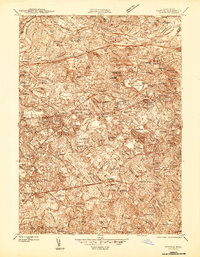
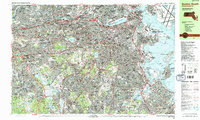
 1893 Boston1893 Print · USGSGreater Boston and the Massachusetts coast are captured here in the late nineteenth century as streetcar suburbs and rail lines redefined the region. Trace family roots and local history across old neighborhoods like Washington Village, coastal landmarks like Fort Independence, and the sprawling Middlesex Fells.4 unique versions available
 - 1903 Map of Boston
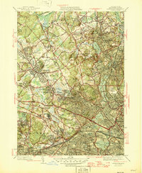
 1903 Boston1903 Print · USGSThe Greater Boston area and its sprawling rail-and-river network are captured here at the turn of the century. Genealogists and historians can trace neighborhood blocks, the grounds of Tufts College, and military landmarks like Ft. Winthrop and Ft. Independence.13 unique versions available
 - 1943 Map of Boston
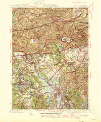
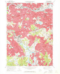
 1943 Boston1943 Print · USGSGreater Boston and its southern suburbs appear here during the mobilization of the early 1940s. Genealogists and historians can trace the early footprints of Commonwealth Airport, military sites like Fort Winthrop, and local institutions such as Pondville State Hospital.
 - 1944 Map of Newton
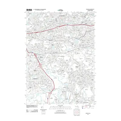
 1944 Newton1944 Print · USGSThe western suburbs of Boston thrive in the mid-1940s, defined by the winding Charles River and a dense network of rail lines. Genealogists and local historians can trace family plots and parish boundaries at Newton Cem, St Gabriels Monastery, and the Christian Science Sanatorium.
 - 1944 Map of Lexington
 1944 Lexington1944 Print · USGSMiddlesex County is shown in the early 1940s, capturing a landscape of historic town centers and massive institutional estates. Researchers can trace ancestral sites at Ye Old Burying Ground or locate vanished rail stops like Munroe Sta and Beaver Bk Sta.
 - 1946 Map of Lexington
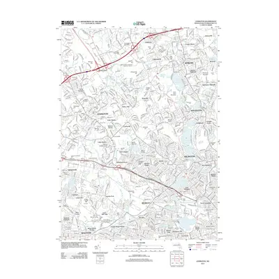
 1946 Lexington1946 Print · USGSSuburban Middlesex County comes alive in the mid-forties, showing the postwar density of these classic Boston-area towns. Researchers can locate significant institutional grounds like the Metropolitan State Hospital or trace family roots at Wildwood Cem and Oak Grove Cemetery.3 unique versions available
 - 1946 Map of Newton
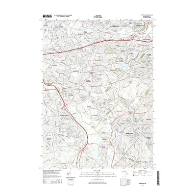
 1946 Newton1946 Print · USGSNewton and the western Boston suburbs are captured in the mid-1940s, showcasing a landscape of established estates, institutions, and rail lines. You can trace early 20th-century neighborhoods and landmarks like the Chestnut Hill Reservoir, Boston College, and Needham Junction.3 unique versions available
 - 1948 Map of Boston
 1948 Boston1948 Print · USGSEastern Massachusetts and southern New Hampshire appear at an industrial peak in the late 1940s, just as suburban growth began to accelerate. Genealogists and historians can trace rail lines like the Boston and Albany RR or locate coastal landmarks like Graves Lighthouse and Fort Devens.2 unique versions available
 - 1954 Map of Newton
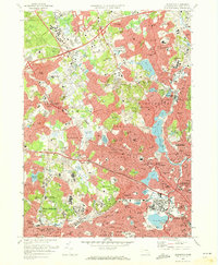
 1954 Newton1954 Print · USGSGreater Boston was undergoing rapid postwar transition during the early fifties as highways began to reshape the suburbs. Genealogists and historians can trace family plots and local landmarks like Newton Cem, the Perkins Institution for Blind, and the Boston and Albany RR corridor.
 - 1956 Map of Lexington
 1956 Lexington1956 Print · USGSMiddlesex County was rapidly evolving in the mid-1950s as suburban residential belts thickened between established town centers. Genealogists and historians can trace institutional history at Metropolitan State Hospital or locate ancestral sites like the Old Burying Ground and St Patricks Cem.3 unique versions available
 - 1956 Map of Newton
 1956 Newton1956 Print · USGSThe Charles River corridor in the mid-fifties shows a mature landscape of commuter rail suburbs and prestigious institutions. Researchers can trace family history through local landmarks like Newton Cemetery, neighborhood hubs like Waban Sta, and Hancock Village.3 unique versions available
 - 1956 Map of Boston, 1967 Print
 1956 Boston1967 Print · USGSThe Massachusetts coastline and industrial interior are seen here during the mid-century peak of suburban and highway expansion. Researchers can trace historic harbor defenses like Fort Revere, local landmarks such as Faneuil Hall, and the vast Parker River National Wildlife Refuge.6 unique versions available
 - 1958 Map of Boston
 1958 Boston1958 Print · USGSEastern Massachusetts and southern New Hampshire are shown at the height of the industrial era, before the full expansion of the interstate system. Trace coastal defenses at Fort Warren, historic rail lines like the Boston and Maine, and the development of the Mass. 128 corridor.2 unique versions available
 - 1961 Map of Boston
 1961 Boston1961 Print · USGSThe Massachusetts coastline and its industrial interior are detailed here in the mid-twentieth century, from the Monadnock highlands to Cape Cod. Researchers can trace the rail routes of the Boston and Maine or locate landmarks like Fort Devens and the Wachusett Reservoir.2 unique versions available
 - 1970 Map of Newton, 1973 Print
 1970 Newton1973 Print · USGSThe western suburbs of Boston reached a peak of mid-century density during this era of highway and rail expansion. Researchers can trace historic parish boundaries and burial sites like Newton Cemetery or locate landmarks like Boston College and the Arnold Arboretum.2 unique versions available
 - 1971 Map of Lexington, 1973 Print
 1971 Lexington1973 Print · USGSThe suburban landscape of Middlesex County is shown here in the early 1970s as historic town centers integrated with major institutional and commercial developments. Genealogists and historians can locate dozens of neighborhood schools, local churches, and expansive grounds such as Mc Lean Hospital and St Patricks Cem.2 unique versions available
 - 1977 Map of Newton, 1980 Print
 1977 Newton1980 Print · USGSThe western suburbs of Boston are revealed in detail during the late seventies, showing the dense development of these historic townships. Trace the winding Charles River through Newton, Brookline, and Watertown to see the region's layout.
 - 1977 Map of Lexington, 1980 Print
 1977 Lexington1980 Print · USGSSuburban Middlesex County comes into sharp focus in the late seventies as residential growth fills the spaces between historic township centers. Researchers can trace the mid-century street patterns of Lexington, Arlington, and Waltham or follow the course of the Aberjona River.
 - 1985 Map of Boston, 1986 Print
 1985 Boston1986 Print · USGSThe Massachusetts urban core and its expanding suburbs are captured in the mid-eighties, showing the reach of the Mass Turnpike and Route 128. Genealogists and historians can trace the evolution of towns from Lexington to Waltham, locating landmarks like Harvard University and Minute Man National Historical Park.
 - 1985 Map of Boston North, 1986 Print
 1985 Boston North1986 Print · USGSGreater Boston's northern tier is captured during the mid-eighties, showing the dense intersection of historic college campuses and industrial rail corridors. Genealogists and historians can trace suburban development around Holy Cross Cemetery and the academic grounds of Harvard University or Tufts University.3 unique versions available
 - 1987 Map of Boston South
 1987 Boston South1987 Print · USGSGreater Boston and its southern suburbs appear in high detail during the late 1980s, showcasing a landscape defined by academia, industry, and the sea. Researchers can trace historic family plots at Mt Auburn Cemetery or locate landmarks like Fort Independence and the Arnold Arboretum.2 unique versions available
 - 1989 Map of Boston
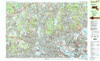
 1989 Boston1989 Print · USGSGreater Boston and the central Massachusetts corridor appear here in the late eighties as suburban growth reshaped the region. Genealogists and historians can trace the transit networks between Boston, Worcester, and Quincy, while locating landmarks like Bunker Hill Monument and Wachusett Reservoir.2 unique versions available
 - 2012 Map of Newton, 2012 Print
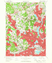
 2012 Newton2012 Print · USGSCovers Watertown, including Boston, Cambridge, and other nearby areas
 - 2012 Map of Lexington, 2012 Print
 2012 Lexington2012 Print · USGSCovers Watertown, including Cambridge, Somerville, and other nearby areas
 - 2015 Map of Newton, 2015 Print
 2015 Newton2015 Print · USGSCovers Watertown, including Boston, Cambridge, and other nearby areas
Showing maps 1-25 of 32
Top cities near Watertown
- Boston historical maps
- Cambridge historical maps
- Quincy historical maps
- Lynn historical maps
- Newton historical maps
- Somerville historical maps
See more
Top neighborhoods of Watertown
Frequently asked questions
- What are the different types of historical maps available for Watertown?
- What is the oldest map of Watertown?
- Where can I purchase historical maps of Watertown for my home or office?
- Where can I download high-res historical maps of Watertown?
- Are there historical topographic maps available for Watertown?
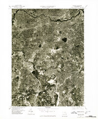
- Is there historical aerial imagery available for Watertown?
- Where are historical maps of Watertown sourced from?