Old Maps of Wrentham, Massachusetts for Academic Research
Study the evolution of Wrentham with 35 high-resolution historic maps. Whether you're teaching, researching, or modeling changes in land use, these maps provide essential visual documentation of urban, environmental, and geographic change.
- Analyze long-term change: Track patterns in development, transportation, and natural features.
- Ideal for environmental or urban studies: Support academic projects with primary historical map data.
- Use in the classroom or lab: Educators and researchers rely on these maps to bring historical context to life.
These maps are a powerful tool for teaching, research, and visualizing how Wrentham has changed over the decades.
Wrentham, MA maps
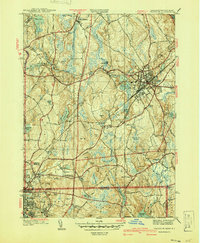
(35)- 1887 Map of Franklin
 1887 Franklin1887 Print · USGSNorfolk County at the peak of the industrial rail era shows a complex landscape of mill villages and expanding transit lines. Trace the development of City Mills, follow the Old Colony R. R. Wrentham Branch, or locate old landmarks like Burnt Swamp Corner.
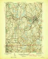
 - 1889 Map of Franklin
 1889 Franklin1889 Print · USGSThe industrial and rail hubs of Norfolk County are detailed in the late 1880s, documenting a time of rapid growth for mill towns and village centers. Researchers can trace historic station stops and hamlets like City Mills, Unionville, and Whitney Sta.
 - 1893 Map of Franklin
 1893 Franklin1893 Print · USGSEastern Massachusetts at the close of the nineteenth century was a landscape of busy rail junctions and riverside mill towns. Researchers can trace the era's industrial footprint through sites like City Mills, Medfield Junc., and the isolated Burnt Swamp Corner.8 unique versions available
 - 1919 Map of Franklin
 1919 Franklin1919 Print · USGSEastern Massachusetts at the end of the Great War was a landscape defined by its river-powered mill towns and expanding rail corridors. Genealogists and local historians can trace family roots through industrial hamlets like City Mills, Unionville, and Sheldonville.2 unique versions available
 - 1921 Map of Franklin, 1942 Print
 1921 Franklin1942 Print · USGSThe Charles River valley was a network of bustling rail junctions and mill villages in the years following the Great War. You can trace the development of towns like Franklin and Medway or locate smaller centers such as City Mills and Unionville.
 - 1939 Map of Franklin, 1942 Print
 1939 Franklin1942 Print · USGSThe Massachusetts and Rhode Island borderlands are captured here just before the war, showing the industrial nodes of Franklin and Woonsocket. Genealogists can trace family roots at Ballow Meetinghouse, St Marys Cem, and the old campus of Dean Academy.
 - 1940 Map of Franklin
 1940 Franklin1940 Print · USGSFranklin and the surrounding border towns of Norfolk County are shown here just before the mid-century. Genealogists can locate specific sites like Dean Academy, St Johns Cem, and the old rail corridors of the New York New Haven and Hartford.2 unique versions available
 - 1940 Map of Wrentham
 1940 Wrentham1940 Print · USGSNorfolk County in the late 1930s shows a landscape of busy mill villages and expanding state institutions. Genealogists can trace family roots through the Bacon Cem, Quaker Cem, and local schools like Vogel Sch and Everett Sch.2 unique versions available
 - 1943 Map of Boston
 1943 Boston1943 Print · USGSGreater Boston and its southern suburbs appear here during the mobilization of the early 1940s. Genealogists and historians can trace the early footprints of Commonwealth Airport, military sites like Fort Winthrop, and local institutions such as Pondville State Hospital.
 - 1945 Map of Franklin, 1956 Print
 1945 Franklin1956 Print · USGSFranklin and the surrounding borderlands of Massachusetts and Rhode Island are captured here during a period of steady post-war growth. Researchers can trace historic family landmarks such as Ballow Meetinghouse, Dean Academy, and the St Johns Cem.
 - 1945 Map of Wrentham, 1958 Print
 1945 Wrentham1958 Print · USGSIn the mid-1940s, this area of Norfolk County maintained its rural character through small villages and institutional landmarks. Researchers can trace ancestral sites like St Marys Cem and Wampum Corner, or locate early infrastructure such as Wilkins Airport.
 - 1946 Map of Wrentham
 1946 Wrentham1946 Print · USGSThe borderlands of Norfolk and Bristol counties are shown here just after the war, at a time when local institutions and textile-era rail lines defined the landscape. Genealogists and historians can trace family plots at Norfolk Cem or Quaker Cem, and locate early landmarks like Wilkins Airport and Wampum Corner.2 unique versions available
 - 1946 Map of Franklin
 1946 Franklin1946 Print · USGSNorfolk County and the Massachusetts-Rhode Island borderlands are documented here at the end of World War II. Researchers can locate family sites at St Johns Cem, trace the rail lines of the New York New Haven and Hartford Railroad, or find old meeting houses like Ballow Meetinghouse.3 unique versions available
 - 1948 Map of Boston
 1948 Boston1948 Print · USGSEastern Massachusetts and southern New Hampshire appear at an industrial peak in the late 1940s, just as suburban growth began to accelerate. Genealogists and historians can trace rail lines like the Boston and Albany RR or locate coastal landmarks like Graves Lighthouse and Fort Devens.2 unique versions available
 - 1956 Map of Boston, 1967 Print
 1956 Boston1967 Print · USGSThe Massachusetts coastline and industrial interior are seen here during the mid-century peak of suburban and highway expansion. Researchers can trace historic harbor defenses like Fort Revere, local landmarks such as Faneuil Hall, and the vast Parker River National Wildlife Refuge.6 unique versions available
 - 1958 Map of Boston
 1958 Boston1958 Print · USGSEastern Massachusetts and southern New Hampshire are shown at the height of the industrial era, before the full expansion of the interstate system. Trace coastal defenses at Fort Warren, historic rail lines like the Boston and Maine, and the development of the Mass. 128 corridor.2 unique versions available
 - 1961 Map of Boston
 1961 Boston1961 Print · USGSThe Massachusetts coastline and its industrial interior are detailed here in the mid-twentieth century, from the Monadnock highlands to Cape Cod. Researchers can trace the rail routes of the Boston and Maine or locate landmarks like Fort Devens and the Wachusett Reservoir.2 unique versions available
 - 1964 Map of Franklin, 1965 Print
 1964 Franklin1965 Print · USGSThe borderlands of Massachusetts and Rhode Island are shown in the mid-1960s as suburban growth met traditional industry. Trace family sites like Ballou Cem, find old neighborhood names like Sheldonville, or locate the Dean Jr College campus.4 unique versions available
 - 1964 Map of Wrentham, 1966 Print
 1964 Wrentham1966 Print · USGSMid-century Norfolk and Bristol counties are shown here as a landscape of state institutions, growing suburban fringes, and deep swamps. Researchers can locate family landmarks like the Quaker Cem, or trace the New Haven and Hartford RR through Wrentham and Plainville.2 unique versions available
 - 1965 Map of Franklin, 1979 Print
 1965 Franklin1979 Print · USGSThe Massachusetts and Rhode Island border country comes into focus in the mid-twentieth century, showing the growing suburbs around Bellingham and Unionville. Genealogists and historians can trace family plots at Ballou Cem and locate institutional landmarks like Dean Junior College and St Marys Abbey.
 - 1977 Map of Wrentham, 1981 Print
 1977 Wrentham1981 Print · USGSEastern Massachusetts is revealed through 1970s aerial imagery during a period of significant suburban growth. Researchers can pinpoint the exact locations of family homes and businesses in Wrentham, Shepardville, and Plainville at this specific moment in history.
 - 1977 Map of Franklin, 1981 Print
 1977 Franklin1981 Print · USGSNorfolk County is seen here during a period of significant suburban growth in the late seventies. Researchers can trace the evolution of residential patterns around Franklin and Bellingham or locate the rural outskirts of Sheldonville.
 - 1985 Map of Boston, 1986 Print
 1985 Boston1986 Print · USGSThe Massachusetts urban core and its expanding suburbs are captured in the mid-eighties, showing the reach of the Mass Turnpike and Route 128. Genealogists and historians can trace the evolution of towns from Lexington to Waltham, locating landmarks like Harvard University and Minute Man National Historical Park.
 - 1987 Map of Franklin
 1987 Franklin1987 Print · USGSFranklin and the Norfolk County borderlands are shown in the late eighties during a period of established institutional and suburban growth. Researchers can locate specific sites like the Wrentham State School, Dean Jr College, and the extensive Franklin State Forest.2 unique versions available
 - 1989 Map of Boston
 1989 Boston1989 Print · USGSGreater Boston and the central Massachusetts corridor appear here in the late eighties as suburban growth reshaped the region. Genealogists and historians can trace the transit networks between Boston, Worcester, and Quincy, while locating landmarks like Bunker Hill Monument and Wachusett Reservoir.2 unique versions available
Showing maps 1-25 of 35
Top cities near Wrentham
- Boston historical maps
- Providence historical maps
- Pawtucket historical maps
- Framingham historical maps
- Taunton historical maps
- East Providence historical maps
See more
Top neighborhoods of Wrentham
- Wampum Corner historical maps
- Wampum Rock historical maps
- West Wrentham historical maps
- Sheldonville historical maps
Frequently asked questions
- What are the different types of historical maps available for Wrentham?
- What is the oldest map of Wrentham?
- Where can I purchase historical maps of Wrentham for my home or office?
- Where can I download high-res historical maps of Wrentham?
- Are there historical topographic maps available for Wrentham?
- Is there historical aerial imagery available for Wrentham?
- Where are historical maps of Wrentham sourced from?