1970s Maps of West Hingham, Hingham
Explore 2 historic maps of West Hingham from the 1970s. These maps offer a rare glimpse into what life looked like during the 1970s — showing old roads, neighborhoods, homes, and landmarks that have changed or disappeared over time.
Whether you're researching your family's past, planning a metal detecting trip, or studying how West Hingham's landscape evolved across the 1970s, these high-resolution maps are a powerful tool for exploring the history of this region.
- Focus on a specific era: All maps on this page are from the 1970s, giving you a focused view of this time period.
- See what’s changed: Compare century-old streets, trails, and buildings to today's modern landscape using overlays and satellite layers.
- Research with precision: Use these maps for genealogy, historical research, land use analysis, or educational projects.
- View, download, or print: Maps are fully viewable online in high resolution, and can be downloaded or printed for your own records.
Start exploring West Hingham's history through authentic maps from the 1970s. This is your window into the past.
West Hingham, Hingham maps
(2)- 1971 Map of Weymouth, 1973 Print
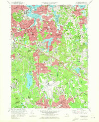 1971 Weymouth1973 Print · USGSThe Norfolk County coastline and its industrial suburbs are captured here in the early seventies, showing a period of high military and maritime activity. Genealogists and local historians can trace the grounds of the South Weymouth Naval Air Station or locate family plots in Fairmount Cemetery and Old North Cem.2 unique versions available
 - 1977 Map of Weymouth, 1980 Print
 1977 Weymouth1980 Print · USGSThe South Shore landscape comes into sharp focus in the late seventies through this detailed aerial orthophoto. Trace the residential growth of Weymouth and Braintree, or study the coastal inlets of the Weymouth Fore River.
End of results
Showing maps 1-2 of 2
Top cities near West Hingham
- Boston historical maps
- Cambridge historical maps
- Brockton historical maps
- Quincy historical maps
- Lynn historical maps
- Somerville historical maps
See more
Frequently asked questions
- What are the different types of historical maps available for West Hingham?
- What is the oldest map of West Hingham?
- Where can I purchase historical maps of West Hingham for my home or office?
- Where can I download high-res historical maps of West Hingham?
- Are there historical topographic maps available for West Hingham?
- Is there historical aerial imagery available for West Hingham?
- Where are historical maps of West Hingham sourced from?