1970s Maps of Straits Pond, Hull
Explore 2 historic maps of Straits Pond from the 1970s. These maps offer a rare glimpse into what life looked like during the 1970s — showing old roads, neighborhoods, homes, and landmarks that have changed or disappeared over time.
Whether you're researching your family's past, planning a metal detecting trip, or studying how Straits Pond's landscape evolved across the 1970s, these high-resolution maps are a powerful tool for exploring the history of this region.
- Focus on a specific era: All maps on this page are from the 1970s, giving you a focused view of this time period.
- See what’s changed: Compare century-old streets, trails, and buildings to today's modern landscape using overlays and satellite layers.
- Research with precision: Use these maps for genealogy, historical research, land use analysis, or educational projects.
- View, download, or print: Maps are fully viewable online in high resolution, and can be downloaded or printed for your own records.
Start exploring Straits Pond's history through authentic maps from the 1970s. This is your window into the past.
Straits Pond, Hull maps
(2)- 1974 Map of Nantasket Beach, 1975 Print
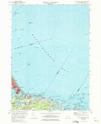 1974 Nantasket Beach1975 Print · USGSThe South Shore's famous coastal resorts and hazardous shipping lanes are detailed in this mid-seventies survey of the Massachusetts coast. Genealogists and historians can trace the footprint of Paragon Park, the homes of North Cohasset, and the offshore beacons like Boston Light.2 unique versions available
 - 1977 Map of Nantasket Beach, 1980 Print
 1977 Nantasket Beach1980 Print · USGSThe South Shore's coastline in the late seventies is captured here through detailed aerial photography. You can trace the residential patterns of North Cohasset and the fragile peninsula of Nantasket Beach along Straits Pond.
End of results
Showing maps 1-2 of 2
Top cities near Straits Pond
- Boston historical maps
- Cambridge historical maps
- Brockton historical maps
- Quincy historical maps
- Lynn historical maps
- Malden historical maps
See more
Frequently asked questions
- What are the different types of historical maps available for Straits Pond?
- What is the oldest map of Straits Pond?
- Where can I purchase historical maps of Straits Pond for my home or office?
- Where can I download high-res historical maps of Straits Pond?
- Are there historical topographic maps available for Straits Pond?
- Is there historical aerial imagery available for Straits Pond?
- Where are historical maps of Straits Pond sourced from?