1960s Maps of Mattapoisett, Massachusetts
Explore 5 historic maps of Mattapoisett from the 1960s. These maps offer a rare glimpse into what life looked like during the 1960s — showing old roads, neighborhoods, homes, and landmarks that have changed or disappeared over time.
Whether you're researching your family's past, planning a metal detecting trip, or studying how Mattapoisett's landscape evolved across the 1960s, these high-resolution maps are a powerful tool for exploring the history of this region.
- Focus on a specific era: All maps on this page are from the 1960s, giving you a focused view of this time period.
- See what’s changed: Compare century-old streets, trails, and buildings to today's modern landscape using overlays and satellite layers.
- Research with precision: Use these maps for genealogy, historical research, land use analysis, or educational projects.
- View, download, or print: Maps are fully viewable online in high resolution, and can be downloaded or printed for your own records.
Start exploring Mattapoisett's history through authentic maps from the 1960s. This is your window into the past.
Mattapoisett, MA maps
(5)- 1962 Map of Sconticut Neck, 1963 Print
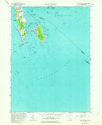 1962 Sconticut Neck1963 Print · USGSThe Buzzards Bay shoreline comes alive in the early sixties, showing the growing residential grid of West Island and the coastal reach of Sconticut Neck. Researchers can trace old property boundaries near Silver Shell Beach and locate offshore markers like Angelica Rock and Brant Island.2 unique versions available
 - 1962 Map of Marion, 1964 Print
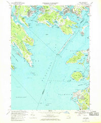
 1962 Marion1964 Print · USGSCoastal Plymouth County villages thrived in the early sixties, balancing a traditional cranberry economy with a growing maritime identity. Genealogists and local historians can trace family roots through Tinkhamtown, Sturtevant Mill, and the Old Landing Cem.
 - 1963 Map of Providence
 1963 Providence1963 Print · USGSSouthern New England's coastal and industrial heartland is captured here in the early sixties, from the Rhode Island mainland to the far reaches of the Cape. Researchers can trace mid-century growth in Providence or locate landmarks on Marthas Vineyard and Nantucket Island.
 - 1967 Map of Onset, 1969 Print
 1967 Onset1969 Print · USGSThe northern shore of Buzzards Bay is captured here in the late sixties, showing a landscape defined by tidal rivers and growing coastal colonies. Researchers can trace the layout of Parkwood Beach, the grounds of the Maritime Academy, and early Cranberry Bogs.3 unique versions available
 - 1967 Map of Woods Hole, 1970 Print
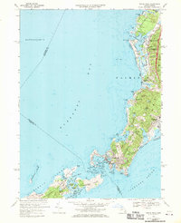 1967 Woods Hole1970 Print · USGSWoods Hole and the Falmouth coastline are captured in the late sixties, a period when maritime research and tourism shaped the local economy. Genealogists and historians can trace rail lines like the Penn Central, find the Crowell Cem, or explore the Elizabeth Islands.3 unique versions available
End of results
Showing maps 1-5 of 5
Top cities near Mattapoisett
- New Bedford historical maps
- Fall River historical maps
- Plymouth historical maps
- Taunton historical maps
- Dartmouth historical maps
- Falmouth historical maps
See more
Top neighborhoods of Mattapoisett
- Cannonville historical maps
- Crescent Beach historical maps
- Harbor Beach historical maps
- Holly Woods historical maps
- Tinkhamtown historical maps
- Alms House historical maps
See more
Frequently asked questions
- What are the different types of historical maps available for Mattapoisett?
- What is the oldest map of Mattapoisett?
- Where can I purchase historical maps of Mattapoisett for my home or office?
- Where can I download high-res historical maps of Mattapoisett?
- Are there historical topographic maps available for Mattapoisett?
- Is there historical aerial imagery available for Mattapoisett?
- Where are historical maps of Mattapoisett sourced from?