1960s Maps of Rochester, Massachusetts
Explore 5 historic maps of Rochester from the 1960s. These maps offer a rare glimpse into what life looked like during the 1960s — showing old roads, neighborhoods, homes, and landmarks that have changed or disappeared over time.
Whether you're researching your family's past, planning a metal detecting trip, or studying how Rochester's landscape evolved across the 1960s, these high-resolution maps are a powerful tool for exploring the history of this region.
- Focus on a specific era: All maps on this page are from the 1960s, giving you a focused view of this time period.
- See what’s changed: Compare century-old streets, trails, and buildings to today's modern landscape using overlays and satellite layers.
- Research with precision: Use these maps for genealogy, historical research, land use analysis, or educational projects.
- View, download, or print: Maps are fully viewable online in high resolution, and can be downloaded or printed for your own records.
Start exploring Rochester's history through authentic maps from the 1960s. This is your window into the past.
Rochester, MA maps
(5)- 1962 Map of Snipatuit Pond, 1963 Print
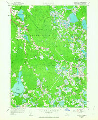 1962 Snipatuit Pond1963 Print · USGSSoutheastern Massachusetts in the early sixties was a landscape of cranberry bogs and glacial ponds. Genealogists and local historians can trace family-named crossroads like Bisbee Corner and Vaughn Hill or locate rural landmarks such as Union Ch.2 unique versions available
 - 1962 Map of Marion, 1964 Print
 1962 Marion1964 Print · USGSCoastal Plymouth County villages thrived in the early sixties, balancing a traditional cranberry economy with a growing maritime identity. Genealogists and local historians can trace family roots through Tinkhamtown, Sturtevant Mill, and the Old Landing Cem.
 - 1963 Map of Providence
 1963 Providence1963 Print · USGSSouthern New England's coastal and industrial heartland is captured here in the early sixties, from the Rhode Island mainland to the far reaches of the Cape. Researchers can trace mid-century growth in Providence or locate landmarks on Marthas Vineyard and Nantucket Island.
 - 1963 Map of Assawompset Pond, 1965 Print
 1963 Assawompset Pond1965 Print · USGSSoutheastern Massachusetts’ massive lake system is shown here in the early sixties, capturing the growth of new shoreline communities. Researchers can trace family ties at Morton Cem, locate the Apponequet Regional High Sch, or explore the storied grounds of Bettys Neck.
 - 1964 Map of New Bedford North, 1966 Print
 1964 New Bedford North1966 Print · USGSCoastal Massachusetts at the height of the mid-century shows the industrial heart of New Bedford and the developing residential reaches of Acushnet. Genealogists and historians can trace numerous schools and cemeteries, from Long Plain Cem to the Sacred Heart Academy.
End of results
Showing maps 1-5 of 5
Top cities near Rochester
- New Bedford historical maps
- Fall River historical maps
- Plymouth historical maps
- Taunton historical maps
- Dartmouth historical maps
- Falmouth historical maps
See more
Top neighborhoods of Rochester
- Wolf Lake historical maps
- Camp Snipatuit historical maps
- Douglas Corner historical maps
- Cowen Corner historical maps
- Sturtevant Mill historical maps
- Howlands historical maps
See more
Frequently asked questions
- What are the different types of historical maps available for Rochester?
- What is the oldest map of Rochester?
- Where can I purchase historical maps of Rochester for my home or office?
- Where can I download high-res historical maps of Rochester?
- Are there historical topographic maps available for Rochester?
- Is there historical aerial imagery available for Rochester?
- Where are historical maps of Rochester sourced from?