1970s Maps of Point Shirley, Winthrop
Explore 2 historic maps of Point Shirley from the 1970s. These maps offer a rare glimpse into what life looked like during the 1970s — showing old roads, neighborhoods, homes, and landmarks that have changed or disappeared over time.
Whether you're researching your family's past, planning a metal detecting trip, or studying how Point Shirley's landscape evolved across the 1970s, these high-resolution maps are a powerful tool for exploring the history of this region.
- Focus on a specific era: All maps on this page are from the 1970s, giving you a focused view of this time period.
- See what’s changed: Compare century-old streets, trails, and buildings to today's modern landscape using overlays and satellite layers.
- Research with precision: Use these maps for genealogy, historical research, land use analysis, or educational projects.
- View, download, or print: Maps are fully viewable online in high resolution, and can be downloaded or printed for your own records.
Start exploring Point Shirley's history through authentic maps from the 1970s. This is your window into the past.
Point Shirley, Winthrop maps
(2)- 1971 Map of Hull, 1972 Print
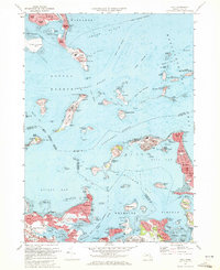 1971 Hull1972 Print · USGSThe outer Boston islands and the Nantasket peninsula are shown in detail during the early seventies, capturing a landscape of coastal defense and maritime history. Researchers can trace the footprints of Fort Warren, the iconic Boston Lighthouse, and institutional sites like the Long Island Hospital.2 unique versions available
 - 1977 Map of Hull, 1980 Print
 1977 Hull1980 Print · USGSThe Massachusetts coastline and Boston Harbor islands are captured in high detail in the late seventies. Genealogists and historians can trace the exact footprint of neighborhoods in Hull and Winthrop or follow the paths of the Fore River and Weir River.
End of results
Showing maps 1-2 of 2
Frequently asked questions
- What are the different types of historical maps available for Point Shirley?
- What is the oldest map of Point Shirley?
- Where can I purchase historical maps of Point Shirley for my home or office?
- Where can I download high-res historical maps of Point Shirley?
- Are there historical topographic maps available for Point Shirley?
- Is there historical aerial imagery available for Point Shirley?
- Where are historical maps of Point Shirley sourced from?