Old Maps of Douglas, Massachusetts for Academic Research
Study the evolution of Douglas with 37 high-resolution historic maps. Whether you're teaching, researching, or modeling changes in land use, these maps provide essential visual documentation of urban, environmental, and geographic change.
- Analyze long-term change: Track patterns in development, transportation, and natural features.
- Ideal for environmental or urban studies: Support academic projects with primary historical map data.
- Use in the classroom or lab: Educators and researchers rely on these maps to bring historical context to life.
These maps are a powerful tool for teaching, research, and visualizing how Douglas has changed over the decades.
Douglas, MA maps
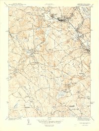
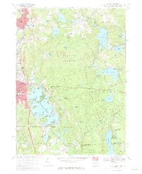
(37)- 1886 Map of Blackstone
 1886 Blackstone1886 Print · USGSThe Blackstone Valley at the height of its industrial era reveals a landscape of thriving mill towns and complex rail networks. Genealogists and historians can trace the growth of Whitinsville, Uxbridge, and East Douglas alongside landmarks like Purgatory Chasm.
 - 1889 Map of Blackstone
 1889 Blackstone1889 Print · USGSThe Blackstone River valley thrives as an industrial powerhouse in the late 1880s, defined by its dense network of mill towns and competing rail lines. Researchers can trace the legacy of textile manufacturing and early commerce through Whitinsville, the Hayden Row P.O., and Millville.
 - 1889 Map of Webster
 1889 Webster1889 Print · USGSSouthern Worcester County and the Connecticut borderlands are shown here in the 1880s, when textile power and steam rail defined the region. Local historians can trace the early layouts of Webster, Oxford, and Rochdale, along with family landmarks like Mugget Hill.
 - 1892 Map of Webster
 1892 Webster1892 Print · USGSWorcester County mill towns and rail junctions thrive in the 1890s as industrial centers along the French River. Genealogists and historians can trace the early footprints of Webster and Oxford, including vanished clusters like Merino Village and Chaseville.9 unique versions available
 - 1893 Map of Blackstone
 1893 Blackstone1893 Print · USGSThe Blackstone River valley at the height of its industrial era reveals a landscape of vital mill towns and complex rail networks. Genealogists and historians can trace the early footprints of Whitinsville, Uxbridge, and Millville alongside landmarks like Purgatory Chasm.2 unique versions available
 - 1900 Map of Blackstone
 1900 Blackstone1900 Print · USGSThe Blackstone Valley was a bustling manufacturing corridor when this late Victorian-era survey was published. Genealogists and historians can trace the industrial mill villages along the Blackstone River, including Whitinsville, Manchaug, and Millville.7 unique versions available
 - 1908 Map of Quinsigamond
 1908 Quinsigamond1908 Print · USGSCentral Massachusetts and its bordering states are seen here in the early twentieth century as industry and transit reshaped the Blackstone Valley. Genealogists and historians can trace the early footprints of Worcester, the expansion of the Wachusett Reservoir, and rail lines like the Boston and Albany Railroad.3 unique versions available
 - 1919 Map of Blackstone
 1919 Blackstone1919 Print · USGSThe Blackstone Valley at the end of the Great War was a dense network of industrial villages and crucial rail junctions. Genealogists and historians can trace the family-named landmarks of the era, from Saundersville and Linwood to the heights of Dorothy Hill.2 unique versions available
 - 1921 Map of Webster
 1921 Webster1921 Print · USGSThe industrial valleys and hill towns of southern Worcester County are seen here just after the Great War. Genealogists can trace the rail-centered growth of Webster and Auburn Sta. or locate old village centers like Cherry Valley and Rochdale.
 - 1943 Map of Quinsigamond
 1943 Quinsigamond1943 Print · USGSCentral Massachusetts and its bordering states appear here during the Second World War as a powerhouse of rail infrastructure and public institutions. Researchers can trace the legacy of the region through landmarks like Grafton State Hospital, the Wachusett Reservoir, and the deep industrial roots of the Blackstone River.
 - 1944 Map of Uxbridge
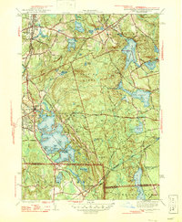
 1944 Uxbridge1944 Print · USGSThe Blackstone Valley at the height of its industrial era reveals a landscape of mill villages, canals, and iron rails. Genealogists can trace family roots through numerous local burial grounds like St Marys Cem or locate former schoolhouses such as the Aldrich Sch and Happy Hollow Sch.5 unique versions available
 - 1946 Map of Oxford
 1946 Oxford1946 Print · USGSThe Massachusetts and Rhode Island borderlands are captured here in the mid-forties, showing the complex shorelines of Lake Chaubunagungamaug. Researchers can trace the CENTRAL TURNPIKE, early lakeside colonies at Colonial Park, and the wooded expanse of the Douglas Cedar Swamp.2 unique versions available
 - 1948 Map of Boston
 1948 Boston1948 Print · USGSEastern Massachusetts and southern New Hampshire appear at an industrial peak in the late 1940s, just as suburban growth began to accelerate. Genealogists and historians can trace rail lines like the Boston and Albany RR or locate coastal landmarks like Graves Lighthouse and Fort Devens.2 unique versions available
 - 1953 Map of Oxford, 1954 Print
 1953 Oxford1954 Print · USGSSouthern Worcester County was a busy intersection of industry and nature in the early fifties. Trace the rail lines of the New York New Haven and Hartford and locate landmarks like the St Joseph Cem and the sprawling Lake Chaubunagungamaug.3 unique versions available
 - 1953 Map of Uxbridge, 1955 Print
 1953 Uxbridge1955 Print · USGSThe Blackstone Valley villages of the mid-twentieth century are captured here alongside the rural borderlands of Rhode Island. Genealogists can trace family heritage through the Aldrich and Buffum cemeteries or locate the Tasseltop Sch.3 unique versions available
 - 1956 Map of Boston, 1967 Print
 1956 Boston1967 Print · USGSThe Massachusetts coastline and industrial interior are seen here during the mid-century peak of suburban and highway expansion. Researchers can trace historic harbor defenses like Fort Revere, local landmarks such as Faneuil Hall, and the vast Parker River National Wildlife Refuge.6 unique versions available
 - 1958 Map of Boston
 1958 Boston1958 Print · USGSEastern Massachusetts and southern New Hampshire are shown at the height of the industrial era, before the full expansion of the interstate system. Trace coastal defenses at Fort Warren, historic rail lines like the Boston and Maine, and the development of the Mass. 128 corridor.2 unique versions available
 - 1961 Map of Boston
 1961 Boston1961 Print · USGSThe Massachusetts coastline and its industrial interior are detailed here in the mid-twentieth century, from the Monadnock highlands to Cape Cod. Researchers can trace the rail routes of the Boston and Maine or locate landmarks like Fort Devens and the Wachusett Reservoir.2 unique versions available
 - 1964 Map of Oxford
 1964 Oxford1964 Print · USGSThe tri-state border region of Massachusetts, Connecticut, and Rhode Island comes alive in this mid-century survey. Genealogists and researchers can map family plots at St Joseph Cem or trace the winding shores of Lake Chaubunagungamaug.
 - 1969 Map of Oxford, 1971 Print
 1969 Oxford1971 Print · USGSThe tri-state border region of Massachusetts, Connecticut, and Rhode Island is captured here in the late sixties, showcasing its industrial villages and extensive pond systems. Researchers can locate St Josephs Cemetery, trace the Penn Central line, or explore the shores of Lake Chaubunagungamaug.4 unique versions available
 - 1969 Map of Uxbridge, 1971 Print
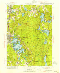
 1969 Uxbridge1971 Print · USGSThe Blackstone Valley industrial corridor is captured here in the late sixties, showing the well-established mill towns of Massachusetts and Rhode Island. Researchers can locate family sites and landmarks like Evergreen Cem, East Douglas Station, and the Halfway House.4 unique versions available
 - 1975 Map of Uxbridge, 1981 Print
 1975 Uxbridge1981 Print · USGSThe industrial landscape of the Blackstone Valley comes into focus in the mid-1970s, showing the intersection of river-power and rail-era mill towns. Researchers can trace the developed centers of Uxbridge and Whitinsville or locate the smaller settlement at Tasseltop.
 - 1975 Map of Oxford, 1981 Print
 1975 Oxford1981 Print · USGSSouthern Worcester County in the mid-seventies is captured here via detailed aerial imagery. Researchers can trace the shoreline of Lake Chaubunagungamaug or survey the dense canopy of Douglas Woods and the village of Manchaug.
 - 1982 Map of Uxbridge, 1984 Print
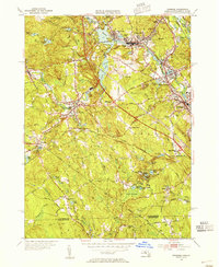
 1982 Uxbridge1984 Print · USGSThe Blackstone Valley at the start of the eighties shows a landscape of historic mill towns and river-driven industry. Researchers can trace family ties and civic growth through sites like the Chestnut Hill Meeting House, Northbridge High Sch, and Evergreen Cem.
 - 1982 Map of Webster, 1984 Print
 1982 Webster1984 Print · USGSCentral Massachusetts and the tri-state borderlands come into focus in the early eighties, centered on the industrial corridors of the French River. Genealogists can trace family sites at St Anthony Cem or locate the campus of Nichols College and the various mills of Webster.2 unique versions available
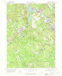
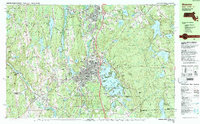
Showing maps 1-25 of 37
Top cities near Douglas
- Worcester historical maps
- Woonsocket historical maps
- Shrewsbury historical maps
- Milford historical maps
- Johnston historical maps
- Smithfield historical maps
See more
Top neighborhoods of Douglas
Frequently asked questions
- What are the different types of historical maps available for Douglas?
- What is the oldest map of Douglas?
- Where can I purchase historical maps of Douglas for my home or office?
- Where can I download high-res historical maps of Douglas?
- Are there historical topographic maps available for Douglas?
- Is there historical aerial imagery available for Douglas?
- Where are historical maps of Douglas sourced from?