Old Maps of Worcester, Massachusetts
Explore 77 old maps of Worcester, spanning from 1885 to today. These high-resolution historic maps reveal how streets, neighborhoods, landmarks, and natural features evolved over time — perfect for genealogy, metal detecting, research, and local history exploration.
What you can do with these maps:
- See how Worcester changed over time: Compare historical maps to modern-day views to trace roads, homesites, rail lines & more.
- View detailed metadata: Each map includes creators, publishers, year, scale, and archive source.
- Overlay maps with satellite & LiDAR: Visualize the past alongside modern tools to explore terrain & human change.
- Trusted historical sources: Maps sourced from the USGS, Library of Congress, and other archives.
- Access maps your way: View online, download high-res files, or order prints for personal or research use.
Start exploring old maps of Worcester to uncover forgotten places, hidden landmarks, and the deep history beneath your feet.
Worcester, MA maps
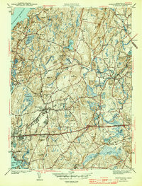
(77)- 1885 Map of Worcester
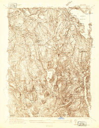
 1885 Worcester1885 Print · USGSWorcester and its surrounding mill towns are captured here in the late nineteenth century during a peak era of rail expansion and industrial growth. Researchers can trace ancestral roots through specific local hubs like Wire Village, the Sterling Camp Grounds, and the grounds of the State Lunatic Hospital.
 - 1886 Map of Worcester
 1886 Worcester1886 Print · USGSWorcester and its surrounding hill towns are captured here in the mid-1880s, revealing a landscape of early industrial hamlets and expanding rail lines. Genealogists and local historians can trace the foundations of the State Lunatic Hospital or locate historic settlements like Quinapoxet Village and Wire Village.
 - 1886 Map of Blackstone
 1886 Blackstone1886 Print · USGSThe Blackstone Valley at the height of its industrial era reveals a landscape of thriving mill towns and complex rail networks. Genealogists and historians can trace the growth of Whitinsville, Uxbridge, and East Douglas alongside landmarks like Purgatory Chasm.
 - 1887 Map of Marlboro
 1887 Marlboro1887 Print · USGSWorcester County is captured during its industrial transition, showing the vital rail and water networks connecting the region. Researchers can trace the development of the Metropolitan Waterworks Aqueduct and locate landmarks like the Westboro Insane Hospital and Lyman School.
 - 1889 Map of Marlboro
 1889 Marlboro1889 Print · USGSCentral Massachusetts at the close of the 1880s was a bustling hub of rail activity and industrial development. Local historians can trace early transportation routes like the Fitchburg Railroad through Still River Station and find old-world village names like Rock Bottom and Straw Hollow.
 - 1889 Map of Blackstone
 1889 Blackstone1889 Print · USGSThe Blackstone River valley thrives as an industrial powerhouse in the late 1880s, defined by its dense network of mill towns and competing rail lines. Researchers can trace the legacy of textile manufacturing and early commerce through Whitinsville, the Hayden Row P.O., and Millville.
 - 1889 Map of Webster
 1889 Webster1889 Print · USGSSouthern Worcester County and the Connecticut borderlands are shown here in the 1880s, when textile power and steam rail defined the region. Local historians can trace the early layouts of Webster, Oxford, and Rochdale, along with family landmarks like Mugget Hill.
 - 1892 Map of Webster
 1892 Webster1892 Print · USGSWorcester County mill towns and rail junctions thrive in the 1890s as industrial centers along the French River. Genealogists and historians can trace the early footprints of Webster and Oxford, including vanished clusters like Merino Village and Chaseville.9 unique versions available
 - 1892 Map of Worcester
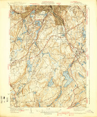
 1892 Worcester1892 Print · USGSWorcester and its northern hill towns are captured here in the late nineteenth century before the expansion of modern reservoirs. Researchers can trace the early rail networks through Sterling Junction or locate landmarks like the State Lunatic Hospital and Wire Village.10 unique versions available
 - 1893 Map of Blackstone
 1893 Blackstone1893 Print · USGSThe Blackstone River valley at the height of its industrial era reveals a landscape of vital mill towns and complex rail networks. Genealogists and historians can trace the early footprints of Whitinsville, Uxbridge, and Millville alongside landmarks like Purgatory Chasm.2 unique versions available
 - 1896 Map of Marlboro
 1896 Marlboro1896 Print · USGSCentral Massachusetts in the late nineteenth century is a landscape of thriving mill towns and interlocking rail lines. Researchers can trace the Victorian-era footprints of Marlboro and Clinton, locating vanished stops like Still River Station and family landmarks like Whittemore Hill.
 - 1898 Map of Marlboro
 1898 Marlboro1898 Print · USGSCentral Massachusetts was a thriving network of rail and river industry at the end of the Victorian era. Genealogists and historians can trace the early layouts of manufacturing hubs like Clinton and Hudson or find smaller vanished locales like Rockbottom and Pratt Junction.8 unique versions available
 - 1900 Map of Blackstone
 1900 Blackstone1900 Print · USGSThe Blackstone Valley was a bustling manufacturing corridor when this late Victorian-era survey was published. Genealogists and historians can trace the industrial mill villages along the Blackstone River, including Whitinsville, Manchaug, and Millville.7 unique versions available
 - 1908 Map of Quinsigamond
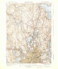
 1908 Quinsigamond1908 Print · USGSCentral Massachusetts and its bordering states are seen here in the early twentieth century as industry and transit reshaped the Blackstone Valley. Genealogists and historians can trace the early footprints of Worcester, the expansion of the Wachusett Reservoir, and rail lines like the Boston and Albany Railroad.3 unique versions available
 - 1919 Map of Blackstone
 1919 Blackstone1919 Print · USGSThe Blackstone Valley at the end of the Great War was a dense network of industrial villages and crucial rail junctions. Genealogists and historians can trace the family-named landmarks of the era, from Saundersville and Linwood to the heights of Dorothy Hill.2 unique versions available
 - 1921 Map of Webster
 1921 Webster1921 Print · USGSThe industrial valleys and hill towns of southern Worcester County are seen here just after the Great War. Genealogists can trace the rail-centered growth of Webster and Auburn Sta. or locate old village centers like Cherry Valley and Rochdale.
 - 1934 Map of Worcester
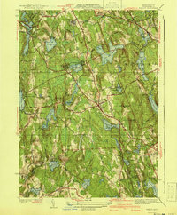
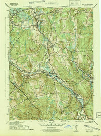
 1934 Worcester1934 Print · USGSMid-depression Worcester and Holden emerge as a dense network of industrial ponds, institutions, and rail lines. Genealogists can trace family connections through the Grove Cem, numerous local schools like Chaffin Sch, and the neighborhoods around Union Sta.
 - 1935 Map of Millbury
 1935 Millbury1935 Print · USGSThe Worcester County countryside in the mid-1930s reveals a dense network of industrial hamlets and rail lines before the modern interstate era. Researchers can trace family roots at St Roche Cem or Bnai Brith Cem and locate vanished schoolhouses like the Hammond Sch.
 - 1937 Map of Paxton
 1937 Paxton1937 Print · USGSWorcester County's upland terrain is captured here in the late 1930s, featuring a landscape of hill-top settlements and industrial hamlets. Genealogists and historians can trace the foundations of Upper Wire Village, locate the Veterans Hospital, or explore the shores of Lake Whittemore.
 - 1939 Map of Worcester South
 1939 Worcester South1939 Print · USGSThe Worcester highlands south of the city appear here in the late 1930s, showing a landscape of textile-era mill ponds and expanding suburban rail stops. Researchers can trace family history at St Johns Cemetery or locate old neighborhood landmarks like St Josephs Ch and Hammond Sch.4 unique versions available
 - 1939 Map of Worcester North
 1939 Worcester North1939 Print · USGSThe Worcester hills and reservoirs appear in detail during the late 1930s, documenting a landscape of expanding educational institutions and civic infrastructure. Genealogists and historians can trace Assumption College, Grove Cem, and the old City Farm near Morningdale.5 unique versions available
 - 1941 Map of Paxton
 1941 Paxton1941 Print · USGSPaxton and the high country of Worcester County are captured here in the early 1940s, showing a region of reservoirs and rural industry. Genealogists can locate family landmarks at Tafts Corner or trace the early industrial sites of Upper Wire Village.3 unique versions available
 - 1943 Map of Shrewsbury
 1943 Shrewsbury1943 Print · USGSShrewsbury and Northboro are depicted in the early 1940s during a period of significant institutional and transit growth in Worcester County. Genealogists and historians can locate legacy sites like the Grafton State Hospital, Pine Grove Cem, and the Boston and Maine RR lines.3 unique versions available
 - 1943 Map of Quinsigamond
 1943 Quinsigamond1943 Print · USGSCentral Massachusetts and its bordering states appear here during the Second World War as a powerhouse of rail infrastructure and public institutions. Researchers can trace the legacy of the region through landmarks like Grafton State Hospital, the Wachusett Reservoir, and the deep industrial roots of the Blackstone River.
 - 1944 Map of Grafton
 1944 Grafton1944 Print · USGSWorcester County is documented here during the mid-1940s, showing a landscape defined by industrial river towns and sprawling institutional grounds. Researchers can trace the heritage of Fisherville, Farnumsville, and Northbridge or locate local landmarks like the Harback Sch and St Johns Cem.5 unique versions available
Showing maps 1-25 of 77
Top cities near Worcester
- Leominster historical maps
- Marlborough historical maps
- Shrewsbury historical maps
- Hudson historical maps
- Westborough historical maps
- Webster historical maps
See more
Top neighborhoods of Worcester
- South Grafton Street historical maps
- Sunderland historical maps
- Oakland Heights historical maps
- Heard Street historical maps
- College Hill historical maps
- Ludlow historical maps
See more
Frequently asked questions
- What are the different types of historical maps available for Worcester?
- What is the oldest map of Worcester?
- Where can I purchase historical maps of Worcester for my home or office?
- Where can I download high-res historical maps of Worcester?
- Are there historical topographic maps available for Worcester?
- Is there historical aerial imagery available for Worcester?
- Where are historical maps of Worcester sourced from?