1970s Maps of Worcester, Massachusetts
Explore 7 historic maps of Worcester from the 1970s. These maps offer a rare glimpse into what life looked like during the 1970s — showing old roads, neighborhoods, homes, and landmarks that have changed or disappeared over time.
Whether you're researching your family's past, planning a metal detecting trip, or studying how Worcester's landscape evolved across the 1970s, these high-resolution maps are a powerful tool for exploring the history of this region.
- Focus on a specific era: All maps on this page are from the 1970s, giving you a focused view of this time period.
- See what’s changed: Compare century-old streets, trails, and buildings to today's modern landscape using overlays and satellite layers.
- Research with precision: Use these maps for genealogy, historical research, land use analysis, or educational projects.
- View, download, or print: Maps are fully viewable online in high resolution, and can be downloaded or printed for your own records.
Start exploring Worcester's history through authentic maps from the 1970s. This is your window into the past.
Worcester, MA maps
(7)- 1973 Map of Worcester South, 1976 Print
 1973 Worcester South1976 Print · USGSSouthern Worcester and Auburn are seen here in the early seventies as suburban growth meets long-standing industrial and academic centers. Researchers can trace family sites at Hope Cemetery, locate the Drive-in Theater, or study the Penn Central rail corridor.2 unique versions available
 - 1974 Map of Worcester North, 1976 Print
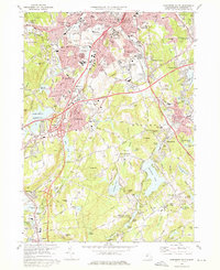
 1974 Worcester North1976 Print · USGSWorcester and its northern suburbs are shown in high detail during the mid-seventies as the city’s industrial and institutional footprint reached its peak. Genealogists and local historians can trace family roots through the Rural Cemetery, historic settlements like Canada Mills, and landmarks such as Worcester Academy.2 unique versions available
 - 1975 Map of Shrewsbury, 1981 Print
 1975 Shrewsbury1981 Print · USGSCentral Massachusetts suburbs undergo visible post-war transformation in the mid-seventies as seen through this detailed aerial survey. Trace the residential growth near Shrewsbury and Northborough or locate early development around Lake Quinsigamond.
 - 1975 Map of Worcester North, 1981 Print
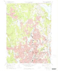
 1975 Worcester North1981 Print · USGSWorcester and its northern reaches are seen here in the mid-1970s during a period of significant suburban growth. Researchers can trace the development of neighborhoods like Chaffinville and Fairlawn alongside the shores of Lake Quinsigamond.
 - 1975 Map of Paxton, 1981 Print
 1975 Paxton1981 Print · USGSCentral Massachusetts appears in sharp detail during the mid-seventies, showing the wooded highlands and growing settlements before modern expansion. Genealogists and local historians can trace the precise boundaries of Paxton, Rutland, and Sibleys Corner as they stood decades ago.
 - 1975 Map of Grafton, 1981 Print
 1975 Grafton1981 Print · USGSThe Blackstone Valley and its mill villages are seen here in the mid-seventies through detailed aerial photography. Researchers can trace the development of historic centers like Fisherville and Wilkinsonville along the Blackstone River.
 - 1975 Map of Worcester South, 1981 Print
 1975 Worcester South1981 Print · USGSCentral Massachusetts undergoes significant suburban growth in the 1970s as highway networks expand across the Blackstone Valley. Researchers can trace land use and development patterns near Auburn, Bramanville, and the Blackstone River.
End of results
Showing maps 1-7 of 7
Top cities near Worcester
- Leominster historical maps
- Marlborough historical maps
- Shrewsbury historical maps
- Hudson historical maps
- Westborough historical maps
- Webster historical maps
See more
Top neighborhoods of Worcester
- South Grafton Street historical maps
- Sunderland historical maps
- Oakland Heights historical maps
- Heard Street historical maps
- College Hill historical maps
- Ludlow historical maps
See more
Frequently asked questions
- What are the different types of historical maps available for Worcester?
- What is the oldest map of Worcester?
- Where can I purchase historical maps of Worcester for my home or office?
- Where can I download high-res historical maps of Worcester?
- Are there historical topographic maps available for Worcester?
- Is there historical aerial imagery available for Worcester?
- Where are historical maps of Worcester sourced from?