1940s Maps of Worcester, Massachusetts
Explore 7 historic maps of Worcester from the 1940s. These maps offer a rare glimpse into what life looked like during the 1940s — showing old roads, neighborhoods, homes, and landmarks that have changed or disappeared over time.
Whether you're researching your family's past, planning a metal detecting trip, or studying how Worcester's landscape evolved across the 1940s, these high-resolution maps are a powerful tool for exploring the history of this region.
- Focus on a specific era: All maps on this page are from the 1940s, giving you a focused view of this time period.
- See what’s changed: Compare century-old streets, trails, and buildings to today's modern landscape using overlays and satellite layers.
- Research with precision: Use these maps for genealogy, historical research, land use analysis, or educational projects.
- View, download, or print: Maps are fully viewable online in high resolution, and can be downloaded or printed for your own records.
Start exploring Worcester's history through authentic maps from the 1940s. This is your window into the past.
Worcester, MA maps
(7)- 1941 Map of Paxton
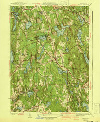 1941 Paxton1941 Print · USGSPaxton and the high country of Worcester County are captured here in the early 1940s, showing a region of reservoirs and rural industry. Genealogists can locate family landmarks at Tafts Corner or trace the early industrial sites of Upper Wire Village.3 unique versions available
 - 1943 Map of Shrewsbury
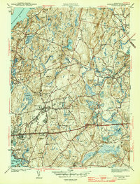 1943 Shrewsbury1943 Print · USGSShrewsbury and Northboro are depicted in the early 1940s during a period of significant institutional and transit growth in Worcester County. Genealogists and historians can locate legacy sites like the Grafton State Hospital, Pine Grove Cem, and the Boston and Maine RR lines.3 unique versions available
 - 1943 Map of Quinsigamond
 1943 Quinsigamond1943 Print · USGSCentral Massachusetts and its bordering states appear here during the Second World War as a powerhouse of rail infrastructure and public institutions. Researchers can trace the legacy of the region through landmarks like Grafton State Hospital, the Wachusett Reservoir, and the deep industrial roots of the Blackstone River.
 - 1944 Map of Grafton
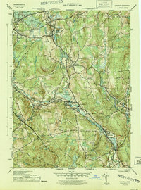 1944 Grafton1944 Print · USGSWorcester County is documented here during the mid-1940s, showing a landscape defined by industrial river towns and sprawling institutional grounds. Researchers can trace the heritage of Fisherville, Farnumsville, and Northbridge or locate local landmarks like the Harback Sch and St Johns Cem.5 unique versions available
 - 1948 Map of Boston
 1948 Boston1948 Print · USGSEastern Massachusetts and southern New Hampshire appear at an industrial peak in the late 1940s, just as suburban growth began to accelerate. Genealogists and historians can trace rail lines like the Boston and Albany RR or locate coastal landmarks like Graves Lighthouse and Fort Devens.2 unique versions available
 - 1948 Map of Worcester South, 1956 Print
 1948 Worcester South1956 Print · USGSSouth of Worcester in the late 1940s, the landscape is a complex mix of industrial mill towns and expanding post-war infrastructure. Genealogists and historians can trace the Massachusetts Turnpike route or locate ancestors at Notre Dame Cemetery and Hope Cemetery.2 unique versions available
 - 1948 Map of Worcester North, 1958 Print
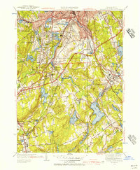
 1948 Worcester North1958 Print · USGSMid-century Worcester and Holden are shown during a period of significant institutional expansion. Researchers can trace the development of Assumption College, locate the Rural Cem, and follow the path of the Boston and Maine Railroad.
End of results
Showing maps 1-7 of 7
Top cities near Worcester
- Leominster historical maps
- Marlborough historical maps
- Shrewsbury historical maps
- Hudson historical maps
- Westborough historical maps
- Webster historical maps
See more
Top neighborhoods of Worcester
- South Grafton Street historical maps
- Sunderland historical maps
- Oakland Heights historical maps
- Heard Street historical maps
- College Hill historical maps
- Ludlow historical maps
See more
Frequently asked questions
- What are the different types of historical maps available for Worcester?
- What is the oldest map of Worcester?
- Where can I purchase historical maps of Worcester for my home or office?
- Where can I download high-res historical maps of Worcester?
- Are there historical topographic maps available for Worcester?
- Is there historical aerial imagery available for Worcester?
- Where are historical maps of Worcester sourced from?