1960s Maps of Worcester, Massachusetts
Explore 6 historic maps of Worcester from the 1960s. These maps offer a rare glimpse into what life looked like during the 1960s — showing old roads, neighborhoods, homes, and landmarks that have changed or disappeared over time.
Whether you're researching your family's past, planning a metal detecting trip, or studying how Worcester's landscape evolved across the 1960s, these high-resolution maps are a powerful tool for exploring the history of this region.
- Focus on a specific era: All maps on this page are from the 1960s, giving you a focused view of this time period.
- See what’s changed: Compare century-old streets, trails, and buildings to today's modern landscape using overlays and satellite layers.
- Research with precision: Use these maps for genealogy, historical research, land use analysis, or educational projects.
- View, download, or print: Maps are fully viewable online in high resolution, and can be downloaded or printed for your own records.
Start exploring Worcester's history through authentic maps from the 1960s. This is your window into the past.
Worcester, MA maps
(6)- 1960 Map of Worcester South, 1962 Print
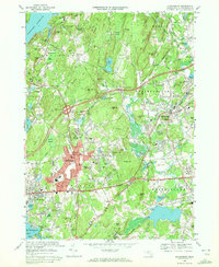
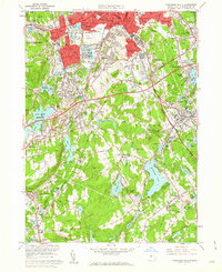 1960 Worcester South1962 Print · USGSWorcester and its southern townships are captured here at the start of the sixties, showing a landscape of dense industry and classic New England town centers. Researchers can trace historic family plots at Hope Cemetery or locate old industrial sites like the Millbury Woolen Pd and Drury Square.2 unique versions available
 - 1960 Map of Worcester North, 1962 Print
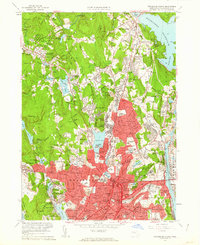 1960 Worcester North1962 Print · USGSMid-century Worcester and Holden appear here as a landscape of dense neighborhoods, academic institutions, and growing infrastructure. Genealogists and historians can trace family locations near the Rural Cemetery or locate old industrial nodes like Canada Mills and Chaffinville.2 unique versions available
 - 1961 Map of Boston
 1961 Boston1961 Print · USGSThe Massachusetts coastline and its industrial interior are detailed here in the mid-twentieth century, from the Monadnock highlands to Cape Cod. Researchers can trace the rail routes of the Boston and Maine or locate landmarks like Fort Devens and the Wachusett Reservoir.2 unique versions available
 - 1965 Map of Paxton, 1968 Print
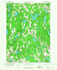 1965 Paxton1968 Print · USGSMid-century central Massachusetts reveals a landscape of industrial hamlets and vital waterworks as the region supported the growth of neighboring Worcester. Trace the historic layouts of Upper Wire Village, find the Quaker Cem, or locate the VA Hospital and Anna Maria College.2 unique versions available
 - 1969 Map of Grafton, 1971 Print
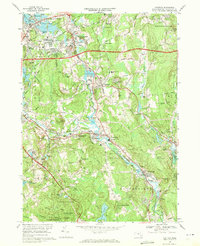 1969 Grafton1971 Print · USGSThe Blackstone River valley during the late sixties shows a landscape of industrial mill villages and expanding transit corridors. Trace family history through numerous landmarks like St Phillips Cem, the Grafton State Hospital, or the many family-named hills like Brigham Hill.2 unique versions available
 - 1969 Map of Shrewsbury, 1972 Print
 1969 Shrewsbury1972 Print · USGSShrewsbury and Northborough appear here in the late sixties as the suburban landscape began to integrate with major highway interchanges. Genealogists and local historians can locate institutional landmarks like the Grafton State Hospital, Hillcrest Cem, and the Masonic Nursing Home.4 unique versions available
End of results
Showing maps 1-6 of 6
Top cities near Worcester
- Leominster historical maps
- Marlborough historical maps
- Shrewsbury historical maps
- Hudson historical maps
- Westborough historical maps
- Webster historical maps
See more
Top neighborhoods of Worcester
- South Grafton Street historical maps
- Sunderland historical maps
- Oakland Heights historical maps
- Heard Street historical maps
- College Hill historical maps
- Ludlow historical maps
See more
Frequently asked questions
- What are the different types of historical maps available for Worcester?
- What is the oldest map of Worcester?
- Where can I purchase historical maps of Worcester for my home or office?
- Where can I download high-res historical maps of Worcester?
- Are there historical topographic maps available for Worcester?
- Is there historical aerial imagery available for Worcester?
- Where are historical maps of Worcester sourced from?