1970s Maps of Winchendon, Massachusetts
Explore 7 historic maps of Winchendon from the 1970s. These maps offer a rare glimpse into what life looked like during the 1970s — showing old roads, neighborhoods, homes, and landmarks that have changed or disappeared over time.
Whether you're researching your family's past, planning a metal detecting trip, or studying how Winchendon's landscape evolved across the 1970s, these high-resolution maps are a powerful tool for exploring the history of this region.
- Focus on a specific era: All maps on this page are from the 1970s, giving you a focused view of this time period.
- See what’s changed: Compare century-old streets, trails, and buildings to today's modern landscape using overlays and satellite layers.
- Research with precision: Use these maps for genealogy, historical research, land use analysis, or educational projects.
- View, download, or print: Maps are fully viewable online in high resolution, and can be downloaded or printed for your own records.
Start exploring Winchendon's history through authentic maps from the 1970s. This is your window into the past.
Winchendon, MA maps
(7)- 1970 Map of Templeton, 1972 Print
 1970 Templeton1972 Print · USGSTempleton and Baldwinville are shown in the early seventies during a period of steady growth and forest preservation. Genealogists and local historians can locate several family cemeteries such as Pine Grove Cem and Greenlawn Cem, or trace the rail lines through Depot Pond.3 unique versions available
 - 1970 Map of Gardner, 1972 Print
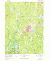
 1970 Gardner1972 Print · USGSIn the early 1970s, the industrial character of Worcester County remained anchored by the Boston and Maine Railroad. Researchers can trace the legacy of major institutions like the Gardner State Hospital and Crystal Lake Cem among the hills of Westminster and Gardner.2 unique versions available
 - 1971 Map of Winchendon, 1973 Print
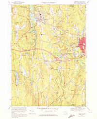
 1971 Winchendon1973 Print · USGSWinchendon and the northern Massachusetts borderlands are captured here in the early 1970s as a landscape of river-driven industry and forest. Trace the rail-and-river history of Waterville, the legacy of the Boston and Maine Railroad, and the Birch Hill Dam.5 unique versions available
 - 1975 Map of Winchendon, 1981 Print
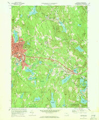
 1975 Winchendon1981 Print · USGSNorth-central Massachusetts and the New Hampshire border are seen here in the mid-1970s. Trace the mill town layouts of Winchendon and Waterville along the Millers River or locate property near Lake Monomonac.
 - 1975 Map of Ashburnham, 1981 Print
 1975 Ashburnham1981 Print · USGSNorthern Worcester County and the New Hampshire borderlands are visible in this mid-seventies aerial study. Local historians can trace the early residential footprints of Lane Village and Wellville or examine the shoreline of Lake Monomonac.
 - 1975 Map of Templeton, 1981 Print
 1975 Templeton1981 Print · USGSThe Worcester County landscape comes into sharp focus in the mid-seventies, showing the industrial heart of Baldwinville and Templeton. Trace the exact 1975 footprints of riverside settlements along the Otter River and the shores of Queen Lake.
 - 1975 Map of Gardner, 1981 Print
 1975 Gardner1981 Print · USGSWorcester County comes into focus in the mid-1970s through this aerial-based survey of its growing industrial and residential corridors. Genealogists and local historians can trace the exact street layouts and building footprints of Gardner, Westminster, and South Ashburnham.
End of results
Showing maps 1-7 of 7
Top cities near Winchendon
- Leominster historical maps
- Fitchburg historical maps
- Gardner historical maps
- Athol historical maps
- Rutland historical maps
- Westminster historical maps
See more
Top neighborhoods of Winchendon
- Bullardville historical maps
- Harrisville historical maps
- Hydeville historical maps
- Old Center historical maps
- Parkers Station historical maps
- Pequoig historical maps
See more
Frequently asked questions
- What are the different types of historical maps available for Winchendon?
- What is the oldest map of Winchendon?
- Where can I purchase historical maps of Winchendon for my home or office?
- Where can I download high-res historical maps of Winchendon?
- Are there historical topographic maps available for Winchendon?
- Is there historical aerial imagery available for Winchendon?
- Where are historical maps of Winchendon sourced from?