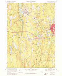
1970 Map of Templeton
USGS Topo · Published 1972About this map
Baldwinville and the Otter River corridor anchor this 1970 snapshot of Worcester County, where the industrial legacy of the Boston and Maine Railroad meets an expansive network of state-managed woodlands. The landscape is defined by its water-powered history, from the Day Millpond to the cluster of ponds surrounding East Templeton. In the southwest, Queen Lake serves as a prominent natural landmark near Goulding Village, while smaller settlements like Brooks Village and Pitcherville appear as established rural nodes. Institutional presence is notable through the Fernald State Sch and the Narragansett Regional High Sch. Large tracts of the Otter River State Forest and Templeton State Forest preserve the surrounding uplands, including Norcross Hill and Crow Hill, highlighting a region balanced between small-town industry and conservation.
Find a feature on this map
123 named features on this map. Tap any name to fly to it.
Don’t see what you’re looking for? This feature index may not catch every label — zoom into the map to look around manually.
Map Details
Editions of this 1970 Templeton Map
3 editions found
Other maps of this area

1885 · Worcester
USGS Topo · 1:62,500

1886 · Worcester
USGS Topo · 1:62,500

1887 · Winchendon
USGS Topo · 1:62,500

1887 · Barre
USGS Topo · 1:62,500

1887 · Fitchburg
USGS Topo · 1:62,500

1889 · Fitchburg
USGS Topo · 1:62,500

1889 · Barre
USGS Topo · 1:62,500

1890 · Winchendon
USGS Topo · 1:62,500

1892 · Worcester
USGS Topo · 1:62,500

1893 · Fitchburg
USGS Topo · 1:62,500