1980s Maps of Au Train Township, Michigan
Explore 9 historic maps of Au Train Township from the 1980s. These maps offer a rare glimpse into what life looked like during the 1980s — showing old roads, neighborhoods, homes, and landmarks that have changed or disappeared over time.
Whether you're researching your family's past, planning a metal detecting trip, or studying how Au Train Township's landscape evolved across the 1980s, these high-resolution maps are a powerful tool for exploring the history of this region.
- Focus on a specific era: All maps on this page are from the 1980s, giving you a focused view of this time period.
- See what’s changed: Compare century-old streets, trails, and buildings to today's modern landscape using overlays and satellite layers.
- Research with precision: Use these maps for genealogy, historical research, land use analysis, or educational projects.
- View, download, or print: Maps are fully viewable online in high resolution, and can be downloaded or printed for your own records.
Start exploring Au Train Township's history through authentic maps from the 1980s. This is your window into the past.
Au Train Township, MI maps
(9)- 1983 Map of Munising
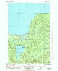
 1983 Munising1983 Print · USGSThe Upper Peninsula lakefront and deep timberlands are documented here in the early eighties, centered on the Munising harbor. Genealogists and historians can trace rail stops along the Soo Line and remote outposts like Shingleton, Eben Junction, and Traunik.2 unique versions available
 - 1984 Map of Au Sable Point, 1985 Print
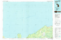 1984 Au Sable Point1985 Print · USGSThe Lake Superior shoreline in the mid-1980s reveals the vast protected reaches of the Upper Peninsula. Trace maritime history through the Au Sable Point Lighthouse and explore the inland timber legacy along the Old Grade Railroad.2 unique versions available
 - 1985 Map of Munising
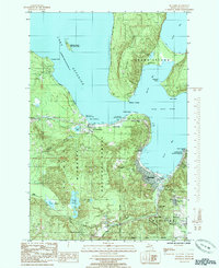 1985 Munising1985 Print · USGSMunising and Grand Island are seen here in the mid-eighties as the region balanced its national forest heritage with growing lakeshore tourism. Researchers can find long-standing landmarks like Williams-Powell Cem, Williams Landing, and the Seventh-day Adventist Sch.
 - 1985 Map of Forest Lake
 1985 Forest Lake1985 Print · USGSThe northern forests of Alger County are captured here in the mid-1980s as a landscape of timber history and hydroelectric power. Researchers can trace the Old RR Grade through Dixon or locate the Au Train Falls Power Plant and Stillman.
 - 1985 Map of Tie Lake
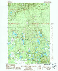
 1985 Tie Lake1985 Print · USGSThe Hiawatha National Forest in the mid-1980s reveals a vast network of glacial lakes and historic timber corridors. Trace the legacy of Upper Peninsula logging along the Old RR Grade and Nahma Grade, or explore the many shorelines of Tie Lake and McComb Lake.
 - 1985 Map of Powell Lake
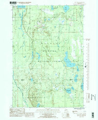
 1985 Powell Lake1985 Print · USGSAlger County’s interior forest lands are captured in the mid-1980s, centered on the diverse wetlands of the Hiawatha National Forest. Researchers can map the proximity of Coalwood to dozens of named water bodies like Powell Lake and Wheelbarrow Lake.
 - 1985 Map of Lake Stella
 1985 Lake Stella1985 Print · USGSUpper Peninsula timberlands and waterways are captured in the mid-1980s as the Hiawatha National Forest spans the Alger and Delta County line. Trace the historic Bay De Noc-Grand Island Trail and old logging routes marked as Old RR Grade.2 unique versions available
 - 1985 Map of Wood Island
 1985 Wood Island1985 Print · USGSGrand Island and the Alger County coast are shown here in the mid-eighties, highlighting the untouched character of these Lake Superior islands. Researchers can trace the interior hydrology of Echo Lake and the various points including North Point and Gull Point.2 unique versions available
 - 1985 Map of Au Train
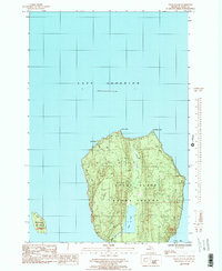
 1985 Au Train1985 Print · USGSThe Lake Superior shoreline and the deep woods of the Upper Peninsula meet here in the mid-1980s. Local researchers can trace the roads around Au Train, locate the Au Train Township Cem, and find old crossings like Doucette Bridge.
End of results
Showing maps 1-9 of 9
Top cities near Au Train Township
- Munising historical maps
- Rock River historical maps
- Christmas historical maps
- Au Train historical maps
- Limestone historical maps
- Chatham historical maps
Top neighborhoods of Au Train Township
- Dixon historical maps
- Stillman historical maps
- Vail historical maps
- Coalwood historical maps
- Munising Junction historical maps
- Christmas historical maps
See more
Frequently asked questions
- What are the different types of historical maps available for Au Train Township?
- What is the oldest map of Au Train Township?
- Where can I purchase historical maps of Au Train Township for my home or office?
- Where can I download high-res historical maps of Au Train Township?
- Are there historical topographic maps available for Au Train Township?
- Is there historical aerial imagery available for Au Train Township?
- Where are historical maps of Au Train Township sourced from?