1970s Maps of Alpena, Michigan
Explore 2 historic maps of Alpena from the 1970s. These maps offer a rare glimpse into what life looked like during the 1970s — showing old roads, neighborhoods, homes, and landmarks that have changed or disappeared over time.
Whether you're researching your family's past, planning a metal detecting trip, or studying how Alpena's landscape evolved across the 1970s, these high-resolution maps are a powerful tool for exploring the history of this region.
- Focus on a specific era: All maps on this page are from the 1970s, giving you a focused view of this time period.
- See what’s changed: Compare century-old streets, trails, and buildings to today's modern landscape using overlays and satellite layers.
- Research with precision: Use these maps for genealogy, historical research, land use analysis, or educational projects.
- View, download, or print: Maps are fully viewable online in high resolution, and can be downloaded or printed for your own records.
Start exploring Alpena's history through authentic maps from the 1970s. This is your window into the past.
Alpena, MI maps
(2)- 1971 Map of Alpena, 1974 Print
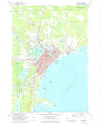 1971 Alpena1974 Print · USGSAlpena is shown here in the early 1970s as a thriving port and industrial hub at the mouth of the Thunder Bay River. Genealogists and historians can trace the city's growth through its many schools, the Detroit and Mackinac rail lines, and landmarks like Evergreen Cemetery.2 unique versions available
 - 1971 Map of North Point, 1974 Print
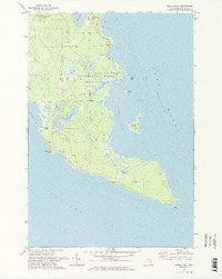 1971 North Point1974 Print · USGSThe Alpena coast on Lake Huron is captured here in the early seventies, showcasing a landscape of state forests and winding bays. Researchers can trace the layout of the Baarley Landing Strip and the shoreline reaches of Misery Bay and North Point.2 unique versions available
End of results
Showing maps 1-2 of 2
Top cities near Alpena
Top neighborhoods of Alpena
Frequently asked questions
- What are the different types of historical maps available for Alpena?
- What is the oldest map of Alpena?
- Where can I purchase historical maps of Alpena for my home or office?
- Where can I download high-res historical maps of Alpena?
- Are there historical topographic maps available for Alpena?
- Is there historical aerial imagery available for Alpena?
- Where are historical maps of Alpena sourced from?