
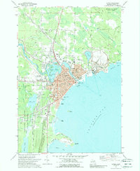
1971 Map of Alpena
USGS Topo · Published 1974About this map
The industrial and maritime character of Alpena is clearly visible in this early 1970s survey, defined by its position where the Thunder Bay River meets Thunder Bay. The city's landscape is a mix of educational and religious institutions, including several parochial schools like St Anne Sch and St Bernard Sch, alongside heavy industrial infrastructure. The presence of a massive Quarry and associated Tailings Pond north of Whitefish Bay indicates the scale of local extraction and processing during this era.
Find a feature on this map
66 named features on this map. Tap any name to fly to it.
Don’t see what you’re looking for? This feature index may not catch every label — zoom into the map to look around manually.
Map Details
Editions of this 1971 Alpena Map
2 editions found
Other maps of this area

1954 · Tawas City
USGS Topo · 1:250,000

1954 · Alpena
USGS Topo · 1:250,000

1957 · Alpena
USGS Topo · 1:250,000

1958 · Alpena
USGS Topo · 1:250,000

1958 · Tawas City
USGS Topo · 1:250,000

1969 · Alpena
USGS Topo · 1:250,000

1971 · Lake Winyah
USGS Topo · 1:24,000

1971 · Long Lake West
USGS Topo · 1:24,000

1971 · Middle Island
USGS Topo · 1:24,000

1971 · North Point
USGS Topo · 1:24,000