1970s Maps of Wilson Township, Michigan
Explore 4 historic maps of Wilson Township from the 1970s. These maps offer a rare glimpse into what life looked like during the 1970s — showing old roads, neighborhoods, homes, and landmarks that have changed or disappeared over time.
Whether you're researching your family's past, planning a metal detecting trip, or studying how Wilson Township's landscape evolved across the 1970s, these high-resolution maps are a powerful tool for exploring the history of this region.
- Focus on a specific era: All maps on this page are from the 1970s, giving you a focused view of this time period.
- See what’s changed: Compare century-old streets, trails, and buildings to today's modern landscape using overlays and satellite layers.
- Research with precision: Use these maps for genealogy, historical research, land use analysis, or educational projects.
- View, download, or print: Maps are fully viewable online in high resolution, and can be downloaded or printed for your own records.
Start exploring Wilson Township's history through authentic maps from the 1970s. This is your window into the past.
Wilson Township, MI maps
(4)- 1971 Map of Lake Winyah, 1974 Print
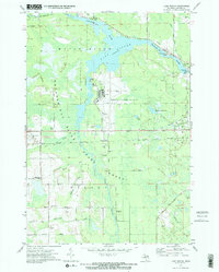 1971 Lake Winyah1974 Print · USGSAlpena County and the Thunder Bay River valley are shown in the early seventies during a period of steady industrial and aviation growth. Researchers can trace the Detroit and Mackinac Railroad through Paxton or locate family sites near Wilson Cem and Kerston Station.2 unique versions available
 - 1971 Map of Lachine, 1974 Print
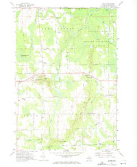 1971 Lachine1974 Print · USGSAlpena County at the start of the seventies shows a rural landscape shaped by the Thunder Bay River and early rail corridors. Researchers can locate the Green Sch, trace the Old Railroad Grade, and find small hubs like Lachine and Spratt.
 - 1972 Map of Big Ravine Creek, 1975 Print
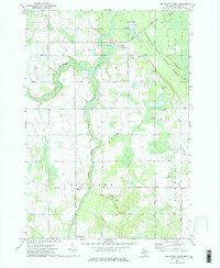 1972 Big Ravine Creek1975 Print · USGSAlpena County's forested river valleys and the northern shores of Hubbard Lake are captured here in the early seventies. Local historians can trace the foundations of the community through rural landmarks like the Township Sch, Community Ch, and the high ground of Nicholson Hill.2 unique versions available
 - 1972 Map of Evans Creek, 1975 Print
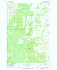 1972 Evans Creek1975 Print · USGSAlpena County was a landscape of dense state forest and quiet township life in the early seventies. Genealogists and local historians can locate early civic centers and family burial sites like Townhall, St Matthew Cem, and Salem Ch.
End of results
Showing maps 1-4 of 4
Top cities near Wilson Township
Top neighborhoods of Wilson Township
Frequently asked questions
- What are the different types of historical maps available for Wilson Township?
- What is the oldest map of Wilson Township?
- Where can I purchase historical maps of Wilson Township for my home or office?
- Where can I download high-res historical maps of Wilson Township?
- Are there historical topographic maps available for Wilson Township?
- Is there historical aerial imagery available for Wilson Township?
- Where are historical maps of Wilson Township sourced from?