1990s Maps of Watton, Covington Township
Explore 2 historic maps of Watton from the 1990s. These maps offer a rare glimpse into what life looked like during the 1990s — showing old roads, neighborhoods, homes, and landmarks that have changed or disappeared over time.
Whether you're researching your family's past, planning a metal detecting trip, or studying how Watton's landscape evolved across the 1990s, these high-resolution maps are a powerful tool for exploring the history of this region.
- Focus on a specific era: All maps on this page are from the 1990s, giving you a focused view of this time period.
- See what’s changed: Compare century-old streets, trails, and buildings to today's modern landscape using overlays and satellite layers.
- Research with precision: Use these maps for genealogy, historical research, land use analysis, or educational projects.
- View, download, or print: Maps are fully viewable online in high resolution, and can be downloaded or printed for your own records.
Start exploring Watton's history through authentic maps from the 1990s. This is your window into the past.
Watton, Covington Township maps
(2)- 1991 Map of L'Anse
 1991 L'Anse1991 Print · USGSUpper Peninsula life in the early nineties centered on the waters of Keweenaw Bay and the timber-rich highlands of the Huron Mountains. Genealogists and researchers can trace the rail-and-road connections between L'Anse, Baraga, and smaller communities like Pequaming and Assinins.2 unique versions available
 - 1999 Map of Covington, 2004 Print
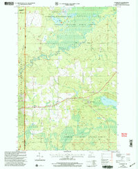 1999 Covington2004 Print · USGSCovington and Watton are documented here in the late twentieth century as the surrounding state and national forests underwent management revisions. Researchers can trace the path of the North Country National Scenic Trail and locate local landmarks like Worm Lake and Tibbetts Falls.
End of results
Showing maps 1-2 of 2
Top cities near Watton
Frequently asked questions
- What are the different types of historical maps available for Watton?
- What is the oldest map of Watton?
- Where can I purchase historical maps of Watton for my home or office?
- Where can I download high-res historical maps of Watton?
- Are there historical topographic maps available for Watton?
- Is there historical aerial imagery available for Watton?
- Where are historical maps of Watton sourced from?