1980s Maps of Spurr Township, Michigan
Explore 6 historic maps of Spurr Township from the 1980s. These maps offer a rare glimpse into what life looked like during the 1980s — showing old roads, neighborhoods, homes, and landmarks that have changed or disappeared over time.
Whether you're researching your family's past, planning a metal detecting trip, or studying how Spurr Township's landscape evolved across the 1980s, these high-resolution maps are a powerful tool for exploring the history of this region.
- Focus on a specific era: All maps on this page are from the 1980s, giving you a focused view of this time period.
- See what’s changed: Compare century-old streets, trails, and buildings to today's modern landscape using overlays and satellite layers.
- Research with precision: Use these maps for genealogy, historical research, land use analysis, or educational projects.
- View, download, or print: Maps are fully viewable online in high resolution, and can be downloaded or printed for your own records.
Start exploring Spurr Township's history through authentic maps from the 1980s. This is your window into the past.
Spurr Township, MI maps
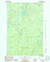
(6)- 1985 Map of Mount Curwood
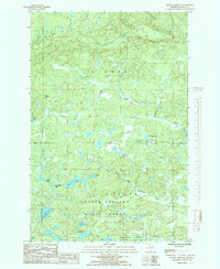 1985 Mount Curwood1985 Print · USGSUpper Peninsula wilderness in Baraga County is captured here in the mid-1980s, centered on the heights of Mount Curwood. Trace the remote water systems of the Copper Country State Forest including Camp 10 Lake, Loon Lake, and the winding Peshekee River.
 - 1985 Map of Summit Lake
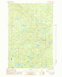 1985 Summit Lake1985 Print · USGSThe Michigan Upper Peninsula wilderness is captured here in the mid-1980s, showcasing the high-country lake chains of the Baraga and Marquette border. Researchers can trace the secluded Boniface Camp and the protected reaches of the Cyrus H. Mc Cormick Experimental Forest.2 unique versions available
 - 1985 Map of Ned Lake, 1986 Print
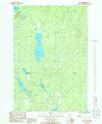 1985 Ned Lake1986 Print · USGSThe Upper Peninsula wilderness at the border of Baraga and Iron counties is documented here in the mid-eighties, centered on the Copper Country State Forest. Naturalists and locals can trace the intricate waterways of Ned Lake, Shank Lake, and the remote Fence River.
 - 1985 Map of Nestoria, 1986 Print
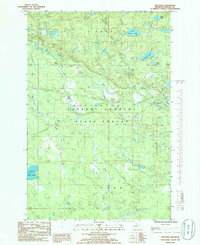 1985 Nestoria1986 Print · USGSIn the mid-eighties, this portion of Baraga County remained a quiet expanse of the Copper Country State Forest centered on the junction at Nestoria. Researchers can map the intricate water systems of the Sturgeon River, locate local landmarks like Tioga Falls, and trace the path of the Pelkie road.
 - 1985 Map of Nelson Lake, 1986 Print
 1985 Nelson Lake1986 Print · USGSThe Baraga and Iron county line comes alive in the mid-1980s, showing a remote landscape of Michigan timberland and interior waterways. Trace the courses of the West Branch Michigamme River, identify old water works at Hamilton Dam, and locate the secluded Fence Lake.
 - 1989 Map of Iron River, 1990 Print
 1989 Iron River1990 Print · USGSUpper Peninsula mining and timber lands are documented here in the late 1980s, showcasing the region's industrial and natural interface. Researchers can trace the iron heritage through the Monongahela Mine and local junctions like Kelso Junction and Amasa.
End of results
Showing maps 1-6 of 6
Top cities near Spurr Township
Top neighborhoods of Spurr Township
Frequently asked questions
- What are the different types of historical maps available for Spurr Township?
- What is the oldest map of Spurr Township?
- Where can I purchase historical maps of Spurr Township for my home or office?
- Where can I download high-res historical maps of Spurr Township?
- Are there historical topographic maps available for Spurr Township?
- Is there historical aerial imagery available for Spurr Township?
- Where are historical maps of Spurr Township sourced from?