1960s Maps of Bangor Township, Michigan
Explore 4 historic maps of Bangor Township from the 1960s. These maps offer a rare glimpse into what life looked like during the 1960s — showing old roads, neighborhoods, homes, and landmarks that have changed or disappeared over time.
Whether you're researching your family's past, planning a metal detecting trip, or studying how Bangor Township's landscape evolved across the 1960s, these high-resolution maps are a powerful tool for exploring the history of this region.
- Focus on a specific era: All maps on this page are from the 1960s, giving you a focused view of this time period.
- See what’s changed: Compare century-old streets, trails, and buildings to today's modern landscape using overlays and satellite layers.
- Research with precision: Use these maps for genealogy, historical research, land use analysis, or educational projects.
- View, download, or print: Maps are fully viewable online in high resolution, and can be downloaded or printed for your own records.
Start exploring Bangor Township's history through authentic maps from the 1960s. This is your window into the past.
Bangor Township, MI maps
(4)- 1967 Map of Essexville, 1968 Print
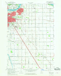 1967 Essexville1968 Print · USGSLate 1960s Essexville and Bay City appear at the height of their mid-century industrial development along the Saginaw River. Genealogists and local historians can locate several parish schools and historic burial grounds, such as St Patrick Cem and Elm Lawn Cemetery.3 unique versions available
 - 1967 Map of Bay City NE, 1969 Print
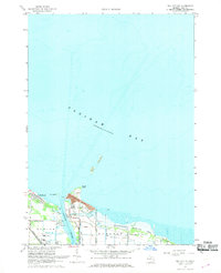 1967 Bay City NE1969 Print · USGSSaginaw Bay's industrial and recreational shoreline comes alive in the 1960s as it transitions from busy river channels to protected wildlife areas. Genealogists and historians can trace the rail lines of the Chesapeake and Ohio and the settlement at Aplin Beach.2 unique versions available
 - 1967 Map of Kawkawlin, 1969 Print
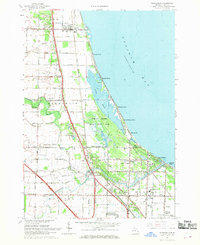 1967 Kawkawlin1969 Print · USGSSaginaw Bay's shoreline in the late sixties is a mix of growing beach communities and vast protected wetlands. You can trace family roots at St Ann Cem, locate old schoolhouses like Townhall Sch, or follow the Penn Central rail lines through Linwood.3 unique versions available
 - 1967 Map of Bay City, 1969 Print
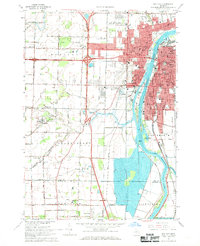 1967 Bay City1969 Print · USGSBay City and the Saginaw River valley are captured here in the late sixties during a period of suburban expansion and industrial transition. Researchers can locate numerous parochial schools like St Stanislaus Sch, family plots at Oak Ridge Cemetery, and the early campus of Saginaw Valley College.2 unique versions available
End of results
Showing maps 1-4 of 4
Top cities near Bangor Township
- Saginaw historical maps
- Bay City historical maps
- Kawkawlin historical maps
- Kochville historical maps
- Essexville historical maps
- Beaver historical maps
See more
Top neighborhoods of Bangor Township
- Donahue Beach historical maps
- Killarney Beach historical maps
- Tobico Beach historical maps
- Aplin Beach historical maps
- Little Killarney Beach historical maps
- Lagoon Beach historical maps
Frequently asked questions
- What are the different types of historical maps available for Bangor Township?
- What is the oldest map of Bangor Township?
- Where can I purchase historical maps of Bangor Township for my home or office?
- Where can I download high-res historical maps of Bangor Township?
- Are there historical topographic maps available for Bangor Township?
- Is there historical aerial imagery available for Bangor Township?
- Where are historical maps of Bangor Township sourced from?