1970s Maps of Bainbridge Township, Michigan
Explore 2 historic maps of Bainbridge Township from the 1970s. These maps offer a rare glimpse into what life looked like during the 1970s — showing old roads, neighborhoods, homes, and landmarks that have changed or disappeared over time.
Whether you're researching your family's past, planning a metal detecting trip, or studying how Bainbridge Township's landscape evolved across the 1970s, these high-resolution maps are a powerful tool for exploring the history of this region.
- Focus on a specific era: All maps on this page are from the 1970s, giving you a focused view of this time period.
- See what’s changed: Compare century-old streets, trails, and buildings to today's modern landscape using overlays and satellite layers.
- Research with precision: Use these maps for genealogy, historical research, land use analysis, or educational projects.
- View, download, or print: Maps are fully viewable online in high resolution, and can be downloaded or printed for your own records.
Start exploring Bainbridge Township's history through authentic maps from the 1970s. This is your window into the past.
Bainbridge Township, MI maps
(2)- 1970 Map of Coloma, 1973 Print
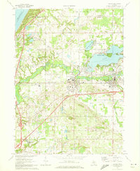 1970 Coloma1973 Print · USGSSouthwestern Michigan's orchard and lake country is captured here during the 1970s, as regional commerce followed the Paw Paw River and rail lines. Researchers can trace family ties through several local burial grounds like St Joseph Cem and Coloma Cem, or locate landmarks such as the Watervliet Mun Airport.2 unique versions available
 - 1970 Map of Sodus, 1973 Print
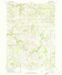 1970 Sodus1973 Print · USGSBerrien County is shown in the early seventies, a time when small crossroads communities and rural family cemeteries still anchored the landscape. Genealogists can locate family-named markers at Byers Cem or Pennyan Cem and trace settlements like Spinks Corners and Sodus.
End of results
Showing maps 1-2 of 2
Top cities near Bainbridge Township
- Benton Harbor historical maps
- Saint Joseph historical maps
- Fair Plain historical maps
- Dowagiac historical maps
- Benton Heights historical maps
- Covert historical maps
See more
Top neighborhoods of Bainbridge Township
Frequently asked questions
- What are the different types of historical maps available for Bainbridge Township?
- What is the oldest map of Bainbridge Township?
- Where can I purchase historical maps of Bainbridge Township for my home or office?
- Where can I download high-res historical maps of Bainbridge Township?
- Are there historical topographic maps available for Bainbridge Township?
- Is there historical aerial imagery available for Bainbridge Township?
- Where are historical maps of Bainbridge Township sourced from?