1970s Maps of Lincoln Charter Township, Michigan
Explore 4 historic maps of Lincoln Charter Township from the 1970s. These maps offer a rare glimpse into what life looked like during the 1970s — showing old roads, neighborhoods, homes, and landmarks that have changed or disappeared over time.
Whether you're researching your family's past, planning a metal detecting trip, or studying how Lincoln Charter Township's landscape evolved across the 1970s, these high-resolution maps are a powerful tool for exploring the history of this region.
- Focus on a specific era: All maps on this page are from the 1970s, giving you a focused view of this time period.
- See what’s changed: Compare century-old streets, trails, and buildings to today's modern landscape using overlays and satellite layers.
- Research with precision: Use these maps for genealogy, historical research, land use analysis, or educational projects.
- View, download, or print: Maps are fully viewable online in high resolution, and can be downloaded or printed for your own records.
Start exploring Lincoln Charter Township's history through authentic maps from the 1970s. This is your window into the past.
Lincoln Charter Township, MI maps
(4)- 1970 Map of Benton Harbor, 1973 Print
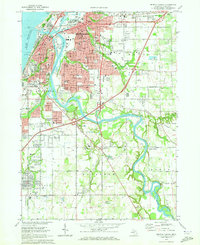 1970 Benton Harbor1973 Print · USGSThe twin cities of the Michigan shoreline are documented here during a period of mid-century growth and industrial rail activity. Researchers can trace the legacy of the House of David, locate old neighborhood landmarks like Calvin Britain Sch, or follow the winding St Joseph River to Kings Landing.2 unique versions available
 - 1970 Map of Baroda, 1973 Print
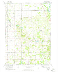 1970 Baroda1973 Print · USGSBerrien County is captured in the early seventies, showing a landscape of small orchards and glacial lakes surrounding Baroda. Genealogists and local historians can trace family-named landmarks like Ruggles Cem, Hickox Landing Strip, and the tracks of the C & O RR.
 - 1970 Map of Stevensville, 1973 Print
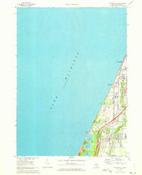 1970 Stevensville1973 Print · USGSThe Berrien County coast during the 1970s shows a landscape of lakeside communities and evolving infrastructure along Lake Michigan. Genealogists and historians can trace local family roots through the Stevensville Cem, Lake Shore Sch, and early residential layouts in Shoreham.2 unique versions available
 - 1970 Map of Bridgman, 1973 Print
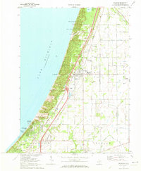 1970 Bridgman1973 Print · USGSThe Berrien County shoreline at the start of the 1970s shows a landscape of massive dunes and growing coastal villages. Genealogists and historians can trace the foundations of Bridgman and Sawyer while locating landmarks like Greenwood Cem and the Chesapeake and Ohio tracks.2 unique versions available
End of results
Showing maps 1-4 of 4
Top cities near Lincoln Charter Township
- Benton Harbor historical maps
- Saint Joseph historical maps
- Fair Plain historical maps
- Buchanan historical maps
- Benton Heights historical maps
- Bridgman historical maps
See more
Top neighborhoods of Lincoln Charter Township
- Glen Lord historical maps
- Derby historical maps
- Waverland Beach historical maps
- Stevensville historical maps
Frequently asked questions
- What are the different types of historical maps available for Lincoln Charter Township?
- What is the oldest map of Lincoln Charter Township?
- Where can I purchase historical maps of Lincoln Charter Township for my home or office?
- Where can I download high-res historical maps of Lincoln Charter Township?
- Are there historical topographic maps available for Lincoln Charter Township?
- Is there historical aerial imagery available for Lincoln Charter Township?
- Where are historical maps of Lincoln Charter Township sourced from?