1900s (20th Century) Maps of Branch County, Michigan
Explore 35 historic maps of Branch County from the 1900s (20th Century). These maps offer a rare glimpse into what life looked like during the 1900s — showing old roads, neighborhoods, homes, and landmarks that have changed or disappeared over time.
Whether you're researching your family's past, planning a metal detecting trip, or studying how Branch County's landscape evolved across the 1900s, these high-resolution maps are a powerful tool for exploring the history of this region.
- Focus on a specific era: All maps on this page are from the 1900s, giving you a focused view of this time period.
- See what’s changed: Compare century-old streets, trails, and buildings to today's modern landscape using overlays and satellite layers.
- Research with precision: Use these maps for genealogy, historical research, land use analysis, or educational projects.
- View, download, or print: Maps are fully viewable online in high resolution, and can be downloaded or printed for your own records.
Start exploring Branch County's history through authentic maps from the 1900s. This is your window into the past.
Branch County, MI maps
(35)- 1918 Map of Union City
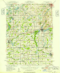
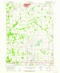
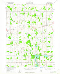
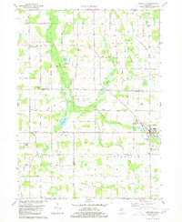
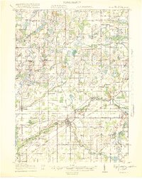 1918 Union City1918 Print · USGSSettled along the forks of the St. Joseph River during the First World War, this region shows a landscape of rail-connected towns and country schoolhouses. Genealogists can trace family footprints at Stanley Corners or find old homesteads near the German Lutheran Church and Mershon School.3 unique versions available
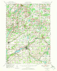
 - 1918 Map of Leonidas
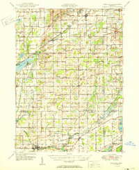
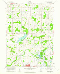
 1918 Leonidas1918 Print · USGSSouthern Michigan at the close of the Great War reveals a landscape of tight-knit farming townships connected by the GRAND RAPIDS AND INDIANA RR. Genealogists can trace family roots through numerous district schools and landmarks like Beard Church, Dutton Cemetery, and Kings Mill.3 unique versions available
 - 1944 Map of Leonidas
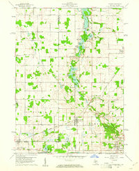
 1944 Leonidas1944 Print · USGSThe rural borderlands of Kalamazoo and St. Joseph counties are shown here as the region's agricultural and rail networks reached their mid-century peak. Genealogists can trace family locations near dozens of named schools and landmarks like Dutton Cemetery, Kings Mill, and Beard Ch.
 - 1947 Map of Union City, 1972 Print
 1947 Union City1972 Print · USGSThe St. Joseph River valley in the late 1940s is shown here at its rural peak, shortly after the war. Family historians can trace ancestral sites through dozens of local landmarks like Morgan Cem, Cobblestone Sch, and Burlington Sta.2 unique versions available
 - 1947 Map of Leonidas, 1976 Print
 1947 Leonidas1976 Print · USGSSouthern Michigan rural life is captured here in the late 1940s, showing a landscape defined by small crossroads settlements and the family-run farms between them. Researchers can trace the exact locations of vanished country schools like Hull Sch and rural landmarks such as Kings Mill and Wakeshma Tabernacle.
 - 1948 Map of Homer, 1968 Print
 1948 Homer1968 Print · USGSSouthern Michigan is captured here just after the war, showing a rural landscape defined by the New York Central rail lines and a dense network of country schoolhouses. Researchers can trace family roots at Shooks Prairie Cem or locate forgotten landmarks like Quaker Mills and Lamm Landing Field.2 unique versions available
 - 1949 Map of Homer
 1949 Homer1949 Print · USGSSouthern Michigan farmland is captured here in the late forties, showing a landscape defined by the upper reaches of the St. Joseph and Kalamazoo Rivers. Genealogists can trace family roots through numerous rural markers like Shooks Prairie Cem, Bentley Corner, and the Quaker Mills Sch.2 unique versions available
 - 1950 Map of Leonidas
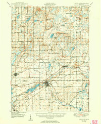
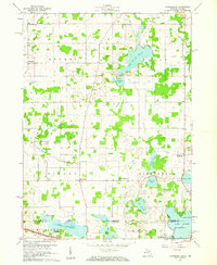
 1950 Leonidas1950 Print · USGSSouthern Michigan’s borderlands at mid-century are defined by the winding St Joseph River and a patchwork of rural school districts. Genealogists can trace family roots through landmarks like Gilson Cem, Dutton Cem, and the numerous rural schools including Factoryville Sch.2 unique versions available
 - 1950 Map of Union City
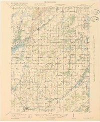
 1950 Union City1950 Print · USGSBranch and Calhoun counties are captured here in the mid-century, showcasing a landscape of riverside towns and agricultural hamlets. Researchers can trace family history through numerous rural landmarks like Burr Oak Cem, Newton Ch, and the Burlington Sta rail stop.2 unique versions available
 - 1953 Map of Fort Wayne, 1963 Print
 1953 Fort Wayne1963 Print · USGSNortheast Indiana and its neighboring borderlands in Michigan and Ohio appear here during a peak era of rail and road expansion. Researchers can trace the massive rail networks of the Nickel Plate Road and Wabash or locate lakeside landmarks like Lake Wawasee and Clear Lake.4 unique versions available
 - 1956 Map of Fort Wayne
 1956 Fort Wayne1956 Print · USGSThe tri-state borderlands of Indiana, Michigan, and Ohio are captured here in the mid-fifties, centered on the growing industrial hub of Fort Wayne. Researchers can trace the heavy rail lines of the New York Central and Pennsylvania alongside prominent water features like Lake Wawasee and the Maumee River.2 unique versions available
 - 1958 Map of Grand Rapids, 1973 Print
 1958 Grand Rapids1973 Print · USGSSouthern Michigan at the peak of the postwar era shows a landscape of burgeoning cities and new interstate highways. Trace family roots and regional growth in Grand Rapids, Battle Creek, and the glacial lake country around Gun Lake or Gull Lake.2 unique versions available
 - 1960 Map of Coldwater West, 1961 Print
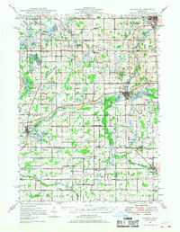
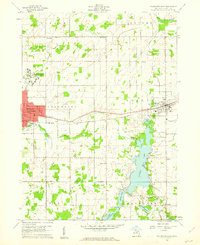
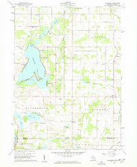
 1960 Coldwater West1961 Print · USGSBranch County at the start of the 1960s shows the growth of the Coldwater area along the New York Central railroad and a distinctive chain of glacial lakes. Genealogists and local historians can locate family landmarks like Lockwood Ch, Oak Grove Cem, and several one-room schoolhouse sites.2 unique versions available
 - 1960 Map of Coldwater East, 1961 Print
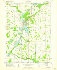
 1960 Coldwater East1961 Print · USGSBranch County enters the sixties with a thriving network of lakefront communities and rail-side industry. Researchers can trace family roots through Mason Cem, visit the old Mudge Sch, or follow the New York Central through Quincy.2 unique versions available
 - 1960 Map of Bronson North, 1961 Print
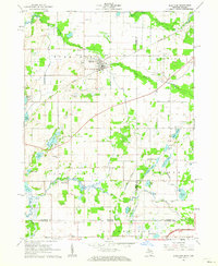
 1960 Bronson North1961 Print · USGSBranch County townships were primarily rural and agricultural at the start of the sixties, shaped by the local creek systems and the railroad. Genealogists and local historians can trace family locations near Matteson Lake, York Cem, and Moore Sch.
 - 1960 Map of Bronson South, 1961 Print
 1960 Bronson South1961 Print · USGSThe Michigan-Indiana borderlands are captured here in the early sixties, showing the rural landscape between the railroad at Bronson and the Indiana Toll Road. Researchers can locate family landmarks like St Marys Cem, Greenfield Mills, and Hickory Corners Sch.2 unique versions available
 - 1960 Map of Camden, 1961 Print
 1960 Camden1961 Print · USGSHillsdale County and the tri-state border region are captured here in the early sixties as the rail-and-river economy of southern Michigan flourished. Researchers can trace family sites like Maple Lawn Cem or follow the New York Central through Montgomery.2 unique versions available
 - 1960 Map of Kinderhook, 1961 Print
 1960 Kinderhook1961 Print · USGSThe Michigan-Indiana state line comes alive in the early sixties, showing the rural communities of Kinderhook and East Gilead amid a landscape of glacial lakes. Researchers can trace family roots at Knauss Cem or Ovid Cem and locate vanished landmarks like Snow Prairie Sch.
 - 1960 Map of Allen, 1961 Print
 1960 Allen1961 Print · USGSBranch and Hillsdale counties are captured here in the early 1960s, showing a traditional Michigan landscape of rail towns and lakeside camps. Researchers can locate the Jordan Sch, trace the New York Central line through Allen, or find the Lake Cem.3 unique versions available
 - 1960 Map of California, 1962 Print
 1960 California1962 Print · USGSBranch County, Michigan, and Steuben County, Indiana, meet at the state line in this 1960 survey. Researchers can trace rural lineages through numerous cemeteries like Wilson Cem and Lester Cem or locate the old Amish Sch and Stokes Chapel.2 unique versions available
 - 1961 Map of Grand Rapids
 1961 Grand Rapids1961 Print · USGSSouthern Michigan at the dawn of the 1960s reveals a region shaped by major river systems and a robust rail network. Trace mid-century industrial growth and land use from Grand Rapids to the Fort Custer Military Reservation and Gun Lake.
 - 1961 Map of Colon, 1962 Print
 1961 Colon1962 Print · USGSSt. Joseph County at the start of the 1960s reveals a landscape of interconnected glacial lakes and small agricultural hubs. Researchers can trace family roots at Lakeside Cem, locate the Mennonite Ch, or follow the New York Central rail line.2 unique versions available
 - 1961 Map of Burr Oak, 1962 Print
 1961 Burr Oak1962 Print · USGSThe Michigan-Indiana borderlands are captured here in the early sixties, showing the agricultural and rail-oriented life of the region. Researchers can locate many family-history sites like Dutch Settlement Cem, Burr Oak, and the Fawn River Sch.2 unique versions available
 - 1962 Map of Grand Rapids
 1962 Grand Rapids1962 Print · USGSMid-century Southern Michigan is mapped here at a time of massive growth, showing the expanding urban footprints of Grand Rapids and Lansing. Researchers can trace the legacy of the Grand Trunk Western RR, find historic boundaries of the Fort Custer Military Reservation, or locate sporting camps around Gun Lake.2 unique versions available
 - 1980 Map of Litchfield
 1980 Litchfield1980 Print · USGSSouth-central Michigan farmland is captured here in the 1970s at the convergence of Hillsdale, Calhoun, and Branch counties. Local researchers can locate family sites near Bentleys Corners, South Litchfield Ch, and Shooks Prairie Cem.
Showing maps 1-25 of 35
Top cities of Branch County
Frequently asked questions
- What are the different types of historical maps available for Branch County?
- What is the oldest map of Branch County?
- Where can I purchase historical maps of Branch County for my home or office?
- Where can I download high-res historical maps of Branch County?
- Are there historical topographic maps available for Branch County?
- Is there historical aerial imagery available for Branch County?
- Where are historical maps of Branch County sourced from?