1980s Maps of Branch County, Michigan
Explore 9 historic maps of Branch County from the 1980s. These maps offer a rare glimpse into what life looked like during the 1980s — showing old roads, neighborhoods, homes, and landmarks that have changed or disappeared over time.
Whether you're researching your family's past, planning a metal detecting trip, or studying how Branch County's landscape evolved across the 1980s, these high-resolution maps are a powerful tool for exploring the history of this region.
- Focus on a specific era: All maps on this page are from the 1980s, giving you a focused view of this time period.
- See what’s changed: Compare century-old streets, trails, and buildings to today's modern landscape using overlays and satellite layers.
- Research with precision: Use these maps for genealogy, historical research, land use analysis, or educational projects.
- View, download, or print: Maps are fully viewable online in high resolution, and can be downloaded or printed for your own records.
Start exploring Branch County's history through authentic maps from the 1980s. This is your window into the past.
Branch County, MI maps
(9)- 1980 Map of Litchfield
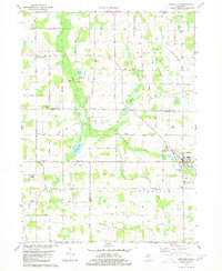 1980 Litchfield1980 Print · USGSSouth-central Michigan farmland is captured here in the 1970s at the convergence of Hillsdale, Calhoun, and Branch counties. Local researchers can locate family sites near Bentleys Corners, South Litchfield Ch, and Shooks Prairie Cem.
 - 1980 Map of Tekonsha
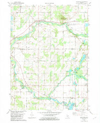
 1980 Tekonsha1980 Print · USGSTekonsha and the surrounding rural townships are captured in the early eighties as a network of river-side villages and rail-connected farms. Genealogists can trace family names and sites through Riverside Cem, Dayburg Ch, and the outlying settlement of South Butler.
 - 1982 Map of Burlington
 1982 Burlington1982 Print · USGSSouthern Michigan's river valleys and glacial lakes are captured in detail during the early 1980s as the rail and road network matured. Genealogists and local historians can trace family plots at Township Cem or locate old crossings at Hodunk and Burlington.
 - 1982 Map of Leonidas
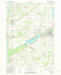
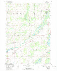 1982 Leonidas1982 Print · USGSSouthern Michigan farm country and river bottoms are captured here in the early eighties, centered on the village of Leonidas. Researchers can trace local lineages through Leonidas Cem or explore the site of Kings Mill and the Mission Ch.
 - 1982 Map of Union City
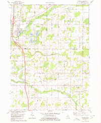
 1982 Union City1982 Print · USGSThe confluence of the St Joseph and Coldwater Rivers defines this Branch County region in the early eighties. Genealogists and local historians can trace family plots at Old Burg Cem and Riverside Cem or locate the old CONRAIL tracks through Sherwood.
 - 1982 Map of Kalamazoo, 1983 Print
 1982 Kalamazoo1983 Print · USGSThe Kalamazoo River valley in the early eighties shows a landscape of growing suburban centers and heavy rail infrastructure. Genealogists and researchers can trace the limits of Kalamazoo and Battle Creek or locate landmarks like Fort Custer National Cemetery and Gull Lake.
 - 1983 Map of Jackson, 1984 Print
 1983 Jackson1984 Print · USGSJackson and the surrounding lake country are shown in the early eighties as a hub of rail transit and outdoor recreation. Local historians can trace institutional footprints like the State Prison Farm or explore the landscape of Minards Mill and Olivet College.
 - 1985 Map of Adrian
 1985 Adrian1985 Print · USGSThe tri-state borderlands of Michigan, Indiana, and Ohio were well-established by the mid-1980s, characterized by a dense network of glacial lakes and agricultural rail hubs. Genealogists and historians can trace rail lines like the Norfolk and Western Railway and locate landmarks such as the Old Indian Treaty Cem or Riverside Cem.
 - 1985 Map of Elkhart
 1985 Elkhart1985 Print · USGSThe Indiana-Michigan borderlands come into focus in the mid-1980s, showcasing the industrial rail hubs and rural agricultural townships of the St. Joseph valley. Genealogists and historians can trace the growth of Elkhart, Goshen, and Three Rivers, or locate smaller communities like Middlebury and White Pigeon.2 unique versions available
End of results
Showing maps 1-9 of 9
Top cities of Branch County
Frequently asked questions
- What are the different types of historical maps available for Branch County?
- What is the oldest map of Branch County?
- Where can I purchase historical maps of Branch County for my home or office?
- Where can I download high-res historical maps of Branch County?
- Are there historical topographic maps available for Branch County?
- Is there historical aerial imagery available for Branch County?
- Where are historical maps of Branch County sourced from?