1950s Maps of Fredonia Township, Michigan
Explore 2 historic maps of Fredonia Township from the 1950s. These maps offer a rare glimpse into what life looked like during the 1950s — showing old roads, neighborhoods, homes, and landmarks that have changed or disappeared over time.
Whether you're researching your family's past, planning a metal detecting trip, or studying how Fredonia Township's landscape evolved across the 1950s, these high-resolution maps are a powerful tool for exploring the history of this region.
- Focus on a specific era: All maps on this page are from the 1950s, giving you a focused view of this time period.
- See what’s changed: Compare century-old streets, trails, and buildings to today's modern landscape using overlays and satellite layers.
- Research with precision: Use these maps for genealogy, historical research, land use analysis, or educational projects.
- View, download, or print: Maps are fully viewable online in high resolution, and can be downloaded or printed for your own records.
Start exploring Fredonia Township's history through authentic maps from the 1950s. This is your window into the past.
Fredonia Township, MI maps
(2)- 1950 Map of Union City
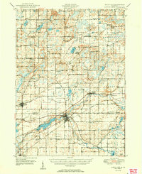 1950 Union City1950 Print · USGSBranch and Calhoun counties are captured here in the mid-century, showcasing a landscape of riverside towns and agricultural hamlets. Researchers can trace family history through numerous rural landmarks like Burr Oak Cem, Newton Ch, and the Burlington Sta rail stop.2 unique versions available
 - 1958 Map of Grand Rapids, 1973 Print
 1958 Grand Rapids1973 Print · USGSSouthern Michigan at the peak of the postwar era shows a landscape of burgeoning cities and new interstate highways. Trace family roots and regional growth in Grand Rapids, Battle Creek, and the glacial lake country around Gun Lake or Gull Lake.2 unique versions available
End of results
Showing maps 1-2 of 2
Top cities near Fredonia Township
- Battle Creek historical maps
- Coldwater historical maps
- Albion historical maps
- Marshall historical maps
- Springfield historical maps
- Marengo historical maps
See more
Top neighborhoods of Fredonia Township
Frequently asked questions
- What are the different types of historical maps available for Fredonia Township?
- What is the oldest map of Fredonia Township?
- Where can I purchase historical maps of Fredonia Township for my home or office?
- Where can I download high-res historical maps of Fredonia Township?
- Are there historical topographic maps available for Fredonia Township?
- Is there historical aerial imagery available for Fredonia Township?
- Where are historical maps of Fredonia Township sourced from?