1940s Maps of Cass County, Michigan
Explore 6 historic maps of Cass County from the 1940s. These maps offer a rare glimpse into what life looked like during the 1940s — showing old roads, neighborhoods, homes, and landmarks that have changed or disappeared over time.
Whether you're researching your family's past, planning a metal detecting trip, or studying how Cass County's landscape evolved across the 1940s, these high-resolution maps are a powerful tool for exploring the history of this region.
- Focus on a specific era: All maps on this page are from the 1940s, giving you a focused view of this time period.
- See what’s changed: Compare century-old streets, trails, and buildings to today's modern landscape using overlays and satellite layers.
- Research with precision: Use these maps for genealogy, historical research, land use analysis, or educational projects.
- View, download, or print: Maps are fully viewable online in high resolution, and can be downloaded or printed for your own records.
Start exploring Cass County's history through authentic maps from the 1940s. This is your window into the past.
Cass County, MI maps
(6)- 1944 Map of Marcellus, 1965 Print
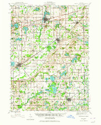 1944 Marcellus1965 Print · USGSSouthwest Michigan townships in Van Buren and Cass counties are documented here during the mid-1940s as a landscape of interconnected glacial lakes and rail lines. Researchers can trace old rural schools like Durkee Sch, the Pere Marquette rail corridor, and family burial grounds such as Wildey Cem.3 unique versions available
 - 1945 Map of Cassopolis, 1967 Print
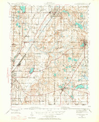 1945 Cassopolis1967 Print · USGSSouthwestern Michigan's rural landscape is captured here in the mid-1940s, showing a dense network of country schools and family-named cemeteries. Genealogists can trace property roots near Barron Lake Cem, Crystal Springs Campground, and numerous landmarks like Morris Chapel.3 unique versions available
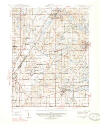
 - 1946 Map of Marcellus
 1946 Marcellus1946 Print · USGSThe rural landscape of Cass and Van Buren counties comes alive in the mid-1940s, showing a transition between railroad hubs and quiet farming hamlets. Genealogists can locate family-named landmarks such as Chamberlain Cem and historic schools like Porter Center Sch or Shannon Sch.2 unique versions available
 - 1947 Map of Cassopolis
 1947 Cassopolis1947 Print · USGSSouthwest Michigan's lake country is captured here just after the war, showing the busy rail-and-river hubs and rural townships. Researchers can locate dozens of neighborhood schoolhouses like Brooklyn Sch and country churches such as Smith Chapel.2 unique versions available
 - 1948 Map of Vandalia
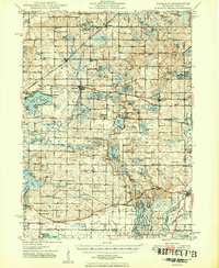
 1948 Vandalia1948 Print · USGSCass County's lake-studded landscape is captured here in the mid-1940s, showing a vibrant network of rural schoolhouses and lakeside retreats. Genealogists and local historians can trace early school districts like Allegheny Sch, locate the Moon Cem, and see the rail economy of Vandalia along the Grand Trunk.5 unique versions available
 - 1949 Map of Vandalia
 1949 Vandalia1949 Print · USGSIn the late 1940s, this pocket of Cass County was a hub of rural life and summer lakeside recreation. Genealogists can locate family landmarks like the Shavehead Cem or Chain Lake Ch, and trace old rail stops along the Grand Trunk.2 unique versions available
End of results
Showing maps 1-6 of 6
Top cities of Cass County
Frequently asked questions
- What are the different types of historical maps available for Cass County?
- What is the oldest map of Cass County?
- Where can I purchase historical maps of Cass County for my home or office?
- Where can I download high-res historical maps of Cass County?
- Are there historical topographic maps available for Cass County?
- Is there historical aerial imagery available for Cass County?
- Where are historical maps of Cass County sourced from?