1980s Maps of Cass County, Michigan
Explore 15 historic maps of Cass County from the 1980s. These maps offer a rare glimpse into what life looked like during the 1980s — showing old roads, neighborhoods, homes, and landmarks that have changed or disappeared over time.
Whether you're researching your family's past, planning a metal detecting trip, or studying how Cass County's landscape evolved across the 1980s, these high-resolution maps are a powerful tool for exploring the history of this region.
- Focus on a specific era: All maps on this page are from the 1980s, giving you a focused view of this time period.
- See what’s changed: Compare century-old streets, trails, and buildings to today's modern landscape using overlays and satellite layers.
- Research with precision: Use these maps for genealogy, historical research, land use analysis, or educational projects.
- View, download, or print: Maps are fully viewable online in high resolution, and can be downloaded or printed for your own records.
Start exploring Cass County's history through authentic maps from the 1980s. This is your window into the past.
Cass County, MI maps
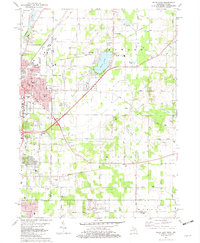
(15)- 1981 Map of Edwardsburg, 1982 Print
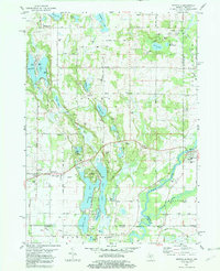
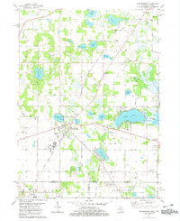 1981 Edwardsburg1982 Print · USGSCrossing the Michigan and Indiana border in the early 1980s, this area centers on the lake-dotted townships of Cass and St. Joseph counties. Researchers can find generational landmarks like the Jefferson Red Brick School, the Grand Trunk Western rail line, and Gods Half Acre Cemetery.
 - 1981 Map of Adamsville, 1982 Print
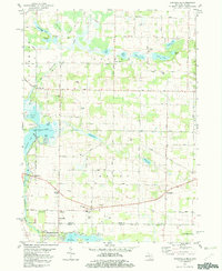 1981 Adamsville1982 Print · USGSSouthern Michigan and northern Indiana border life is captured here in the early eighties, showing a landscape of quiet country crossroads and glacial lakes. Genealogists can locate family landmarks like Five Points Cem, Bethel Ch, and the rural community of Kessington.
 - 1981 Map of Dowagiac, 1982 Print
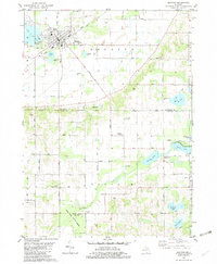
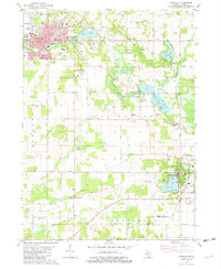 1981 Dowagiac1982 Print · USGSSouthwestern Michigan at the start of the eighties shows a landscape of established lakeside towns and rural colleges. Trace family sites near Dowagiac or Cassopolis, from the Southwestern Michigan College campus to Prospect Hill Cem.
 - 1981 Map of Twin Lakes, 1982 Print
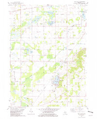 1981 Twin Lakes1982 Print · USGSSouthwestern Michigan’s lake country and the Dowagiac River valley are shown in detail during the early eighties. Researchers can locate family burial sites at North Wayne Cem and Gage Cem or trace the Amtrak line through Glenwood.
 - 1981 Map of Niles East, 1982 Print
 1981 Niles East1982 Print · USGSThe Michigan-Indiana state line and the eastern expansion of NILES are captured here in the early eighties. Researchers can trace family roots at Smith Chapel or Truitt Cem and locate vanished landmarks like the Drive-in Theater and Tyler Memorial Airport.
 - 1981 Map of Marcellus, 1982 Print
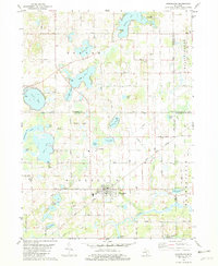 1981 Marcellus1982 Print · USGSMarcellus and the surrounding lake country of Cass County are captured here in the early eighties as the rail-and-road network remained central to rural life. Researchers can trace the Grand Trunk Western line, locate family plots at Bly Cem, or find old gathering spots like Harmony Chapel.
 - 1981 Map of Sister Lakes, 1982 Print
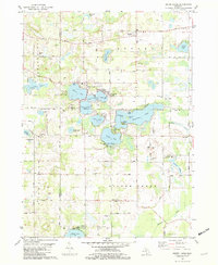 1981 Sister Lakes1982 Print · USGSThe lake country of Southwest Michigan is captured here in the early eighties, showcasing a dense network of resort communities and rural parish life. Genealogists and local historians can locate early burial sites like Keeler Cemetery, the historic Red Mill, and schools such as Indian Lake School.
 - 1981 Map of Vandalia, 1982 Print
 1981 Vandalia1982 Print · USGSCass County prairie lands and lake shores are documented in the early eighties as rural life centered around the rail lines. Trace family sites at Moon Cem and Geneva Sch or locate the shoreline developments at Diamond Shores.
 - 1981 Map of Sumnerville, 1982 Print
 1981 Sumnerville1982 Print · USGSThe borderlands of Berrien and Cass Counties come into focus in the early 1980s, centered on the historic settlements of Sumnerville and Pokagon. Local historians can trace family roots through sites like Pokagon Cem, Franklin Ch, and the winding Dowagiac River.
 - 1981 Map of Mottville, 1982 Print
 1981 Mottville1982 Print · USGSThe Michigan and Indiana borderlands are captured here in the early eighties, showcasing a lake-heavy landscape where the St Joseph River flows through Mottville. Researchers can trace local history through sites like Baldwin Prairie Sch, Plum Grove Cem, and Union.
 - 1981 Map of Decatur, 1982 Print
 1981 Decatur1982 Print · USGSDecatur and the surrounding lake country of Van Buren and Cass Counties are captured here in the early eighties. Genealogists and local researchers can locate numerous country burial grounds and small settlements, including Lakeside Cem, Rose Hill Cem, and the village of Volinia.
 - 1981 Map of Jones, 1982 Print
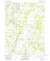
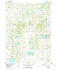 1981 Jones1982 Print · USGSCass County's glacial landscape is captured here in the early eighties, showing the rural communities of Jones and Wakelee. Genealogists and historians can trace family-named sites like Poe Cem, Driskels Lake, and the Grand Trunk Western rail line.
 - 1982 Map of Kalamazoo, 1983 Print
 1982 Kalamazoo1983 Print · USGSThe Kalamazoo River valley in the early eighties shows a landscape of growing suburban centers and heavy rail infrastructure. Genealogists and researchers can trace the limits of Kalamazoo and Battle Creek or locate landmarks like Fort Custer National Cemetery and Gull Lake.
 - 1983 Map of South Bend, 1984 Print
 1983 South Bend1984 Print · USGSThe Indiana-Michigan borderlands come alive in this early 1980s overview of the Michiana region's industrial and academic hubs. Researchers can trace the rail networks of Conrail and the Grand Trunk Western alongside landmarks like the University of Notre Dame and Indiana Dunes State Park.2 unique versions available
 - 1985 Map of Elkhart
 1985 Elkhart1985 Print · USGSThe Indiana-Michigan borderlands come into focus in the mid-1980s, showcasing the industrial rail hubs and rural agricultural townships of the St. Joseph valley. Genealogists and historians can trace the growth of Elkhart, Goshen, and Three Rivers, or locate smaller communities like Middlebury and White Pigeon.2 unique versions available
End of results
Showing maps 1-15 of 15
Top cities of Cass County
Frequently asked questions
- What are the different types of historical maps available for Cass County?
- What is the oldest map of Cass County?
- Where can I purchase historical maps of Cass County for my home or office?
- Where can I download high-res historical maps of Cass County?
- Are there historical topographic maps available for Cass County?
- Is there historical aerial imagery available for Cass County?
- Where are historical maps of Cass County sourced from?