2020s Maps of Mullett Township, Michigan
Explore 4 historic maps of Mullett Township from the 2020s. These maps offer a rare glimpse into what life looked like during the 2020s — showing old roads, neighborhoods, homes, and landmarks that have changed or disappeared over time.
Whether you're researching your family's past, planning a metal detecting trip, or studying how Mullett Township's landscape evolved across the 2020s, these high-resolution maps are a powerful tool for exploring the history of this region.
- Focus on a specific era: All maps on this page are from the 2020s, giving you a focused view of this time period.
- See what’s changed: Compare century-old streets, trails, and buildings to today's modern landscape using overlays and satellite layers.
- Research with precision: Use these maps for genealogy, historical research, land use analysis, or educational projects.
- View, download, or print: Maps are fully viewable online in high resolution, and can be downloaded or printed for your own records.
Start exploring Mullett Township's history through authentic maps from the 2020s. This is your window into the past.
Mullett Township, MI maps
(4)- 2023 Map of Legrand, 2023 Print
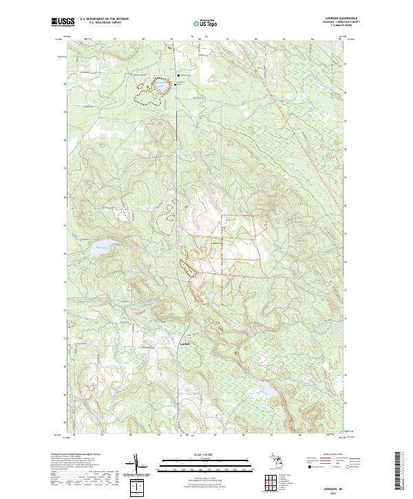 2023 Legrand2023 Print · USGSCheboygan County’s river-fed woodlands are documented in detail during the early 2020s, centered on the settlement of Legrand. Family historians can locate family-named markers like Johnson Grave or trace the North Eastern State Trl and Devereaux Lake.
 - 2023 Map of Aloha, 2023 Print
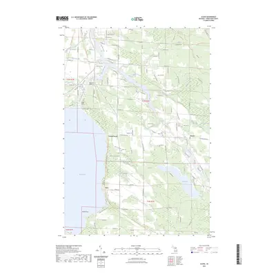 2023 Aloha2023 Print · USGSThe eastern shores of Mullett Lake and the winding Black River are captured here in the early twenty-first century. Researchers can trace local heritage through sites like Owens Cem and the lakeside village of Aloha.
 - 2023 Map of Mullett Lake, 2023 Print
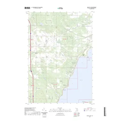 2023 Mullett Lake2023 Print · USGSThe western shore of Mullett Lake comes into focus in this recent survey, highlighting the area's deep-rooted cultural history. Genealogists can trace family heritage through the Saint John's German Lutheran Cem, African - American Cem, and Riggsville Cem.
 - 2023 Map of Indian River, 2023 Print
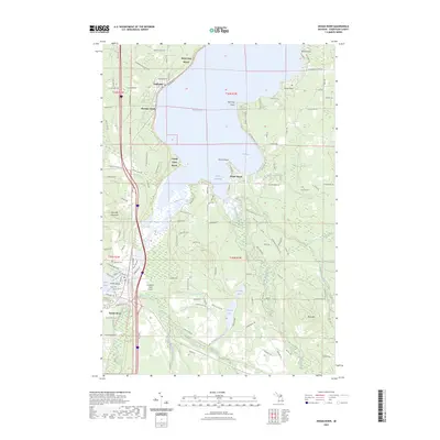 2023 Indian River2023 Print · USGSThe northern Michigan inland waterway is captured here in the 2020s, showing the vital connection between Mullett Lake and Burt Lake. Researchers can trace local landmarks like Oak Hill Cem, the North Central State Trl, and the riverside growth of Indian River.
End of results
Showing maps 1-4 of 4
Top cities near Mullett Township
- Cheboygan historical maps
- Indian River historical maps
- Aloha historical maps
- Carp Lake historical maps
- Pellston historical maps
- Wolverine historical maps
Top neighborhoods of Mullett Township
- Birchwood historical maps
- Long Point historical maps
- Royal Oak Beach historical maps
- Topinabee historical maps
Frequently asked questions
- What are the different types of historical maps available for Mullett Township?
- What is the oldest map of Mullett Township?
- Where can I purchase historical maps of Mullett Township for my home or office?
- Where can I download high-res historical maps of Mullett Township?
- Are there historical topographic maps available for Mullett Township?
- Is there historical aerial imagery available for Mullett Township?
- Where are historical maps of Mullett Township sourced from?