1960s Maps of Crawford County, Michigan
Explore 4 historic maps of Crawford County from the 1960s. These maps offer a rare glimpse into what life looked like during the 1960s — showing old roads, neighborhoods, homes, and landmarks that have changed or disappeared over time.
Whether you're researching your family's past, planning a metal detecting trip, or studying how Crawford County's landscape evolved across the 1960s, these high-resolution maps are a powerful tool for exploring the history of this region.
- Focus on a specific era: All maps on this page are from the 1960s, giving you a focused view of this time period.
- See what’s changed: Compare century-old streets, trails, and buildings to today's modern landscape using overlays and satellite layers.
- Research with precision: Use these maps for genealogy, historical research, land use analysis, or educational projects.
- View, download, or print: Maps are fully viewable online in high resolution, and can be downloaded or printed for your own records.
Start exploring Crawford County's history through authentic maps from the 1960s. This is your window into the past.
Crawford County, MI maps
(4)- 1963 Map of Luzerne, 1964 Print
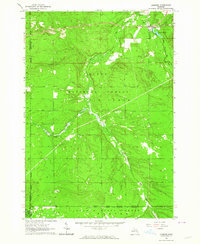 1963 Luzerne1964 Print · USGSOscoda County's forested interior is captured here in the early 1960s, showing the intersection of three major state and national forests. Genealogists and outdoorsmen can trace the early layout of Luzerne, the local Cem, and landmarks like the Luzerne Lookout Tower.
 - 1963 Map of Eldorado, 1964 Print
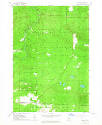 1963 Eldorado1964 Print · USGSCrawford and Roscommon counties were characterized by vast state and national forests and river-driven recreation in the early 1960s. Researchers can trace the legacy of logging and early conservation through landmarks like the Roscommon Lookout Tower, Mason Chapel, and the settlement of Eldorado.3 unique versions available
 - 1963 Map of Luzerne NW, 1964 Print
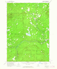 1963 Luzerne NW1964 Print · USGSCrawford County was a hub of military activity and river navigation in the early sixties, dominated by the meeting of the Au Sable forks. Researchers can locate specific river landmarks like McMasters Bridge and Mason Landing Field within the Camp Grayling Military Reservation.4 unique versions available
 - 1963 Map of Red Oak, 1964 Print
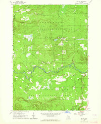 1963 Red Oak1964 Print · USGSOscoda and Crawford counties come to life in the early sixties, showing the vast forest lands along the Au Sable River. Local historians can trace old routes across Parmalee Bridge or locate the site of the Elk Hill Lookout Tower and the settlement at Red Oak.2 unique versions available
End of results
Showing maps 1-4 of 4
Top cities of Crawford County
Frequently asked questions
- What are the different types of historical maps available for Crawford County?
- What is the oldest map of Crawford County?
- Where can I purchase historical maps of Crawford County for my home or office?
- Where can I download high-res historical maps of Crawford County?
- Are there historical topographic maps available for Crawford County?
- Is there historical aerial imagery available for Crawford County?
- Where are historical maps of Crawford County sourced from?