1940s Maps of Crawford County, Michigan
Explore 4 historic maps of Crawford County from the 1940s. These maps offer a rare glimpse into what life looked like during the 1940s — showing old roads, neighborhoods, homes, and landmarks that have changed or disappeared over time.
Whether you're researching your family's past, planning a metal detecting trip, or studying how Crawford County's landscape evolved across the 1940s, these high-resolution maps are a powerful tool for exploring the history of this region.
- Focus on a specific era: All maps on this page are from the 1940s, giving you a focused view of this time period.
- See what’s changed: Compare century-old streets, trails, and buildings to today's modern landscape using overlays and satellite layers.
- Research with precision: Use these maps for genealogy, historical research, land use analysis, or educational projects.
- View, download, or print: Maps are fully viewable online in high resolution, and can be downloaded or printed for your own records.
Start exploring Crawford County's history through authentic maps from the 1940s. This is your window into the past.
Crawford County, MI maps
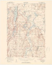
(4)- 1949 Map of Lewiston, 1954 Print
 1949 Lewiston1954 Print · USGSNorthern Michigan’s timber and sporting heritage is on full display here during the late nineteen-forties. Researchers can trace the Michigan Meridian, locate family sites at the Lovells Cemetery, or find old camps like the Au Sable Trout & Gun Club.2 unique versions available
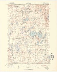
 - 1949 Map of Otsego Lake, 1954 Print
 1949 Otsego Lake1954 Print · USGSOtsego and Crawford Counties were transitioning from a logging past to a recreational and military future at the decade's end. Researchers can trace lakeside developments like Arbutus Beach and the old rail corridor of the New York Central.2 unique versions available
 - 1949 Map of Fletcher, 1955 Print
 1949 Fletcher1955 Print · USGSUpper Michigan's glacial interior is revealed here just after the war, showing the early infrastructure of the Camp Grayling area. Genealogists and historians can trace the New York Central tracks, the settlement of Fletcher, and local landmarks like Beaver Creek Cem.
 - 1949 Map of Grayling, 1955 Print
 1949 Grayling1955 Print · USGSCrawford County was a hub of military training and timber-country life in the late 1940s. Genealogists can locate family names at Cheney Cem or trace rural education at Beaver Creek Sch and the Dept of Conservation Training School.
End of results
Showing maps 1-4 of 4
Top cities of Crawford County
Frequently asked questions
- What are the different types of historical maps available for Crawford County?
- What is the oldest map of Crawford County?
- Where can I purchase historical maps of Crawford County for my home or office?
- Where can I download high-res historical maps of Crawford County?
- Are there historical topographic maps available for Crawford County?
- Is there historical aerial imagery available for Crawford County?
- Where are historical maps of Crawford County sourced from?