1930s Maps of Ensign Township, Michigan
Explore 5 historic maps of Ensign Township from the 1930s. These maps offer a rare glimpse into what life looked like during the 1930s — showing old roads, neighborhoods, homes, and landmarks that have changed or disappeared over time.
Whether you're researching your family's past, planning a metal detecting trip, or studying how Ensign Township's landscape evolved across the 1930s, these high-resolution maps are a powerful tool for exploring the history of this region.
- Focus on a specific era: All maps on this page are from the 1930s, giving you a focused view of this time period.
- See what’s changed: Compare century-old streets, trails, and buildings to today's modern landscape using overlays and satellite layers.
- Research with precision: Use these maps for genealogy, historical research, land use analysis, or educational projects.
- View, download, or print: Maps are fully viewable online in high resolution, and can be downloaded or printed for your own records.
Start exploring Ensign Township's history through authentic maps from the 1930s. This is your window into the past.
Ensign Township, MI maps
(5)- 1932 Map of Rapid River NE
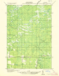 1932 Rapid River NE1932 Print · USGSDelta County's central timber and transit corridors are captured here in the early thirties as the Soo Line railroad connected rural townships. Researchers can pinpoint Ensign, find the Ogontz Cem, and trace the winding Ogontz River past the Seven Mile Dam.
 - 1932 Map of Gladstone SE
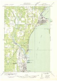 1932 Gladstone SE1932 Print · USGSThe industrial shoreline of Delta County is captured here in the early thirties as the timber and ore trade shaped the coast. Genealogists can locate family landmarks like Fernwood Cem or Soo Hill Sch while tracing the massive C & NW Docks and rail lines.2 unique versions available
 - 1932 Map of Rapid River NW
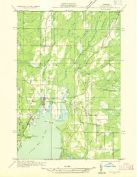 1932 Rapid River NW1932 Print · USGSUpper Peninsula life in the early thirties centers on the confluence of rivers and rails at the head of Little Bay De Noc. Genealogists can trace family footprints at Bethany Ch, Rapid River Cem, and local schools like Fuhirman Sch.2 unique versions available
 - 1932 Map of Rapid River SE
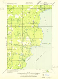 1932 Rapid River SE1932 Print · USGSThe northern shores of Big Bay de Noc appear in the early 1930s as a quiet landscape of coastal marshes and timberlands. Local researchers can trace family roots at Grange Hall, visit the Silver Dale Sch, or locate old camps like Camp Ruh and Indian Town Lake.
 - 1932 Map of Rapid River SW
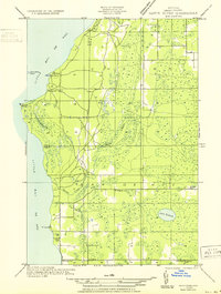 1932 Rapid River SW1932 Print · USGSThe Delta County coast at the start of the 1930s shows a quiet maritime and rural landscape along the northern reaches of Lake Michigan. Researchers can locate coastal landmarks like Squaw Point LH alongside inland community sites like Grange Hall and the Lakewood Cem.
End of results
Showing maps 1-5 of 5
Top cities near Ensign Township
- Escanaba historical maps
- Gladstone historical maps
- Wells historical maps
- Brampton historical maps
- Ensign historical maps
- Nahma historical maps
Top neighborhoods of Ensign Township
Frequently asked questions
- What are the different types of historical maps available for Ensign Township?
- What is the oldest map of Ensign Township?
- Where can I purchase historical maps of Ensign Township for my home or office?
- Where can I download high-res historical maps of Ensign Township?
- Are there historical topographic maps available for Ensign Township?
- Is there historical aerial imagery available for Ensign Township?
- Where are historical maps of Ensign Township sourced from?