1930s Maps of Maple Ridge Township, Michigan
Explore 7 historic maps of Maple Ridge Township from the 1930s. These maps offer a rare glimpse into what life looked like during the 1930s — showing old roads, neighborhoods, homes, and landmarks that have changed or disappeared over time.
Whether you're researching your family's past, planning a metal detecting trip, or studying how Maple Ridge Township's landscape evolved across the 1930s, these high-resolution maps are a powerful tool for exploring the history of this region.
- Focus on a specific era: All maps on this page are from the 1930s, giving you a focused view of this time period.
- See what’s changed: Compare century-old streets, trails, and buildings to today's modern landscape using overlays and satellite layers.
- Research with precision: Use these maps for genealogy, historical research, land use analysis, or educational projects.
- View, download, or print: Maps are fully viewable online in high resolution, and can be downloaded or printed for your own records.
Start exploring Maple Ridge Township's history through authentic maps from the 1930s. This is your window into the past.
Maple Ridge Township, MI maps
(7)- 1932 Map of Gladstone NE
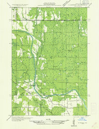
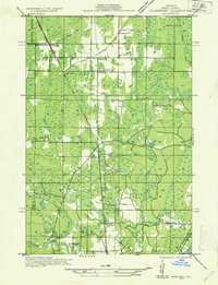 1932 Gladstone NE1932 Print · USGSThe Delta County timberlands and rail corridors are captured here in the early 1930s. Genealogists and researchers can trace the locations of family-named landmarks like Youngs School, Chaison School, and the St Josephs Cem near Perkins.2 unique versions available
 - 1932 Map of Rock SW
 1932 Rock SW1932 Print · USGSUpper Peninsula timber and transit define this 1930s landscape near the Marquette and Delta county line. You can trace the rural school system from North Finn Sch down to St Nicholas Sch or locate family plots at ROCK CEM near the village of Rock.
 - 1932 Map of Trenary SW
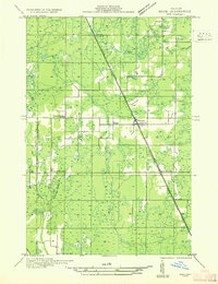
 1932 Trenary SW1932 Print · USGSDelta County timber and transit are captured here in the early thirties as logging camps dotted the Upper Peninsula forest. Genealogists and historians can trace the locations of Dave Woods Camp, Mills Sch, and the unique Dutch Mill along the Rapid River.
 - 1932 Map of Rock NE
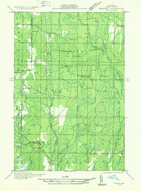
 1932 Rock NE1932 Print · USGSThe timber-heavy border between Alger and Delta Counties comes to life in the early thirties. Trace the legacy of old logging camps and homesteads like Suomi Camp, Gould Homestead, and the Osier Sch along the Chicago and Northwestern rail line.
 - 1932 Map of Rock SE
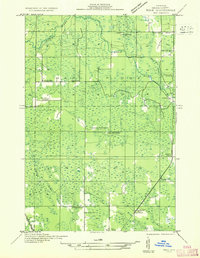 1932 Rock SE1932 Print · USGSThe timber and rail landscapes of Delta County come alive in this early 1930s survey of the Rapid River country. Genealogists and historians can trace family sites like Coty Homestead or locate industrial landmarks such as Clearman Mill and Osier Sch.
 - 1932 Map of Rock NW
 1932 Rock NW1932 Print · USGSMarquette and Delta counties are shown in the early thirties when logging camps and railroads defined life in the Upper Peninsula. Genealogists can trace family-named outposts like Selins Camp, Stenlund Camp, and the settlement of McFarland.
 - 1932 Map of Gladstone NW
 1932 Gladstone NW1932 Print · USGSThe Escanaba River valley in the early 1930s shows a landscape defined by timber and transport. Genealogists and researchers can trace the rural communities of Cornell and Salva, alongside local schoolhouses like St Nicholas Sch and Chandler Sch.
End of results
Showing maps 1-7 of 7
Top cities near Maple Ridge Township
Top neighborhoods of Maple Ridge Township
- Rock historical maps
- Trombly historical maps
- Lathrop historical maps
- Saint Nicholas historical maps
- Campbell historical maps
Frequently asked questions
- What are the different types of historical maps available for Maple Ridge Township?
- What is the oldest map of Maple Ridge Township?
- Where can I purchase historical maps of Maple Ridge Township for my home or office?
- Where can I download high-res historical maps of Maple Ridge Township?
- Are there historical topographic maps available for Maple Ridge Township?
- Is there historical aerial imagery available for Maple Ridge Township?
- Where are historical maps of Maple Ridge Township sourced from?