1980s Maps of Waucedah, Waucedah Township
Explore 2 historic maps of Waucedah from the 1980s. These maps offer a rare glimpse into what life looked like during the 1980s — showing old roads, neighborhoods, homes, and landmarks that have changed or disappeared over time.
Whether you're researching your family's past, planning a metal detecting trip, or studying how Waucedah's landscape evolved across the 1980s, these high-resolution maps are a powerful tool for exploring the history of this region.
- Focus on a specific era: All maps on this page are from the 1980s, giving you a focused view of this time period.
- See what’s changed: Compare century-old streets, trails, and buildings to today's modern landscape using overlays and satellite layers.
- Research with precision: Use these maps for genealogy, historical research, land use analysis, or educational projects.
- View, download, or print: Maps are fully viewable online in high resolution, and can be downloaded or printed for your own records.
Start exploring Waucedah's history through authentic maps from the 1980s. This is your window into the past.
Waucedah, Waucedah Township maps
(2)- 1982 Map of Escanaba
 1982 Escanaba1982 Print · USGSUpper Peninsula timber and mining country come to life in this early 1980s survey of the lakefront and forest interior. Trace family roots and industrial history through settlements like Norway and Gladstone, or locate the Appleton Mine and Fernwood Cem near the rail lines.
 - 1986 Map of Waucedah
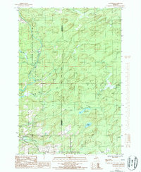 1986 Waucedah1986 Print · USGSUpper Peninsula timberlands and river valleys define this area during the mid-1980s, where the Sturgeon River bisects the state forest. Local historians can trace the settlement at Waucedah, locate the village Cem, and follow the paths of Hamilton Creek and Lost Creek.
End of results
Showing maps 1-2 of 2
Top cities near Waucedah
- Norway historical maps
- Nadeau historical maps
- Pembine historical maps
- Amberg historical maps
- Beecher historical maps
- Powers historical maps
See more
Frequently asked questions
- What are the different types of historical maps available for Waucedah?
- What is the oldest map of Waucedah?
- Where can I purchase historical maps of Waucedah for my home or office?
- Where can I download high-res historical maps of Waucedah?
- Are there historical topographic maps available for Waucedah?
- Is there historical aerial imagery available for Waucedah?
- Where are historical maps of Waucedah sourced from?