1960s Maps of Flushing Charter Township, Michigan
Explore 4 historic maps of Flushing Charter Township from the 1960s. These maps offer a rare glimpse into what life looked like during the 1960s — showing old roads, neighborhoods, homes, and landmarks that have changed or disappeared over time.
Whether you're researching your family's past, planning a metal detecting trip, or studying how Flushing Charter Township's landscape evolved across the 1960s, these high-resolution maps are a powerful tool for exploring the history of this region.
- Focus on a specific era: All maps on this page are from the 1960s, giving you a focused view of this time period.
- See what’s changed: Compare century-old streets, trails, and buildings to today's modern landscape using overlays and satellite layers.
- Research with precision: Use these maps for genealogy, historical research, land use analysis, or educational projects.
- View, download, or print: Maps are fully viewable online in high resolution, and can be downloaded or printed for your own records.
Start exploring Flushing Charter Township's history through authentic maps from the 1960s. This is your window into the past.
Flushing Charter Township, MI maps
(4)- 1969 Map of Montrose, 1971 Print
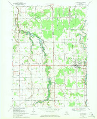 1969 Montrose1971 Print · USGSThe agricultural borderlands of Saginaw and Genesee counties are captured here in the late sixties as traditional farming life centered around the Grand Trunk Western rail line. Researchers can trace family-named sites like Layton Corners, Indian Cem, and Cook Chapel.2 unique versions available
 - 1969 Map of New Lothrop, 1971 Print
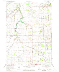 1969 New Lothrop1971 Print · USGSThe rural borderlands of Shiawassee and Genesee counties are captured here in the late sixties, showing a landscape defined by agriculture and family farms. Genealogists can locate family sites near Hazelton Cem, the settlement of Juddville, and the waters of Misteguay Creek.2 unique versions available
 - 1969 Map of Flushing, 1971 Print
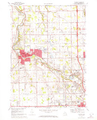 1969 Flushing1971 Print · USGSFlushing and the Flint River valley are captured here during a period of significant mid-century suburban expansion in Genesee County. Genealogists and local historians can locate several burial grounds like Flushing Cemetery and trace the path of the Old Indian Treaty Rdy.
 - 1969 Map of Birch Run South, 1971 Print
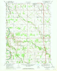 1969 Birch Run South1971 Print · USGSThe rural borders of Saginaw and Genesee counties come into focus in the late sixties as agricultural lands meet growing townships. Researchers can trace family history through landmarks like Indian Cem, Taymouth Ch, and the Edgerton Sch near the Flint River.2 unique versions available
End of results
Showing maps 1-4 of 4
Top cities near Flushing Charter Township
- Flint historical maps
- Burton historical maps
- Flushing historical maps
- Swartz Creek historical maps
- City of Frankenmuth historical maps
- Taymouth historical maps
See more
Top neighborhoods of Flushing Charter Township
Frequently asked questions
- What are the different types of historical maps available for Flushing Charter Township?
- What is the oldest map of Flushing Charter Township?
- Where can I purchase historical maps of Flushing Charter Township for my home or office?
- Where can I download high-res historical maps of Flushing Charter Township?
- Are there historical topographic maps available for Flushing Charter Township?
- Is there historical aerial imagery available for Flushing Charter Township?
- Where are historical maps of Flushing Charter Township sourced from?