1960s Maps of Genesee Charter Township, Michigan
Explore 4 historic maps of Genesee Charter Township from the 1960s. These maps offer a rare glimpse into what life looked like during the 1960s — showing old roads, neighborhoods, homes, and landmarks that have changed or disappeared over time.
Whether you're researching your family's past, planning a metal detecting trip, or studying how Genesee Charter Township's landscape evolved across the 1960s, these high-resolution maps are a powerful tool for exploring the history of this region.
- Focus on a specific era: All maps on this page are from the 1960s, giving you a focused view of this time period.
- See what’s changed: Compare century-old streets, trails, and buildings to today's modern landscape using overlays and satellite layers.
- Research with precision: Use these maps for genealogy, historical research, land use analysis, or educational projects.
- View, download, or print: Maps are fully viewable online in high resolution, and can be downloaded or printed for your own records.
Start exploring Genesee Charter Township's history through authentic maps from the 1960s. This is your window into the past.
Genesee Charter Township, MI maps
(4)- 1969 Map of Davison, 1971 Print
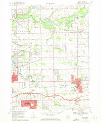 1969 Davison1971 Print · USGSEastern Genesee County underwent significant suburban development in the late sixties as the city of Davison expanded. Researchers can trace the layout of small settlements like Rogersville and find numerous local landmarks such as Holy Rosary High Sch and Davison Cem.2 unique versions available
 - 1969 Map of Otisville, 1971 Print
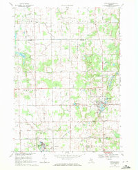 1969 Otisville1971 Print · USGSThe village of Otisville and the surrounding Genesee County countryside are captured here during a period of steady mid-century growth. Researchers can trace family history through sites like East Arbela Ch, Southwest Sch, and the Chesapeake and Ohio Railroad.2 unique versions available
 - 1969 Map of Clio, 1971 Print
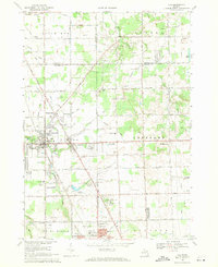 1969 Clio1971 Print · USGSGenesee County and the outskirts of Flint are shown here in the late sixties, where the legacy of rail and road travel meets. Trace local roots through Woodlawn Cem and Clio, or find landmarks like the Auto City Speedway and Bethel Chapel.2 unique versions available
 - 1969 Map of Flint North, 1971 Print
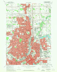 1969 Flint North1971 Print · USGSFlint and Mount Morris are captured during a period of significant urban development in the late sixties. Researchers can find a wealth of local landmarks, from Gracelawn Cemetery and Atwood Stadium to neighborhood sites like Beecher High Sch.2 unique versions available
End of results
Showing maps 1-4 of 4
Top cities near Genesee Charter Township
- Flint historical maps
- Burton historical maps
- Flushing historical maps
- Grand Blanc historical maps
- Atlas historical maps
- Swartz Creek historical maps
See more
Top neighborhoods of Genesee Charter Township
Frequently asked questions
- What are the different types of historical maps available for Genesee Charter Township?
- What is the oldest map of Genesee Charter Township?
- Where can I purchase historical maps of Genesee Charter Township for my home or office?
- Where can I download high-res historical maps of Genesee Charter Township?
- Are there historical topographic maps available for Genesee Charter Township?
- Is there historical aerial imagery available for Genesee Charter Township?
- Where are historical maps of Genesee Charter Township sourced from?