1900s (20th Century) Maps of Butman Township, Michigan
Explore 8 historic maps of Butman Township from the 1900s (20th Century). These maps offer a rare glimpse into what life looked like during the 1900s — showing old roads, neighborhoods, homes, and landmarks that have changed or disappeared over time.
Whether you're researching your family's past, planning a metal detecting trip, or studying how Butman Township's landscape evolved across the 1900s, these high-resolution maps are a powerful tool for exploring the history of this region.
- Focus on a specific era: All maps on this page are from the 1900s, giving you a focused view of this time period.
- See what’s changed: Compare century-old streets, trails, and buildings to today's modern landscape using overlays and satellite layers.
- Research with precision: Use these maps for genealogy, historical research, land use analysis, or educational projects.
- View, download, or print: Maps are fully viewable online in high resolution, and can be downloaded or printed for your own records.
Start exploring Butman Township's history through authentic maps from the 1900s. This is your window into the past.
Butman Township, MI maps
(8)- 1954 Map of Traverse City, 1965 Print
 1954 Traverse City1965 Print · USGSNorthern Michigan’s vast lakeshores and timberlands are captured here in the mid-fifties, showing the region before the modern interstate era. Genealogists and researchers can trace rail connections like the Detroit and Mackinac RR or find old communities such as Suttons Bay, Elk Rapids, and Prudenville.4 unique versions available
 - 1958 Map of Traverse City
 1958 Traverse City1958 Print · USGSNorthern Lower Michigan was a landscape of vast state forests and burgeoning lakeside retreats in the late fifties. Genealogists and historians can trace the rail corridors of the Ann Arbor RR and find established settlements from Elk Rapids to Houghton Lake.2 unique versions available
 - 1969 Map of Edwards, 1971 Print
 1969 Edwards1971 Print · USGSCentral Michigan's lake-studded woodlands are captured here in the late sixties at the intersection of Ogemaw, Roscommon, and Gladwin counties. Genealogists and local historians can trace family-named routes and community landmarks like Edwards Cem, Oak Grove Ch, and the settlement of Edwards.
 - 1969 Map of Butman, 1971 Print
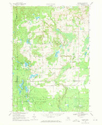
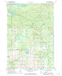 1969 Butman1971 Print · USGSThe northern Michigan woods at the turn of the 1970s reveal a landscape of timber, water, and early oil exploration. Genealogists and historians can trace the rural community of Butman, locate the Butman Cem, and follow the banks of the Sugar River.
 - 1969 Map of Wagarville, 1971 Print
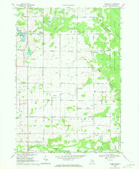 1969 Wagarville1971 Print · USGSGladwin County during the late sixties shows a landscape of river-fed townships and tight-knit rural settlements. Genealogists can trace family roots through the McClure Cem and Ridge Cem, or locate local landmarks like the Miracle Mission and Sugar Rapids.
 - 1969 Map of Secord Lake, 1972 Print
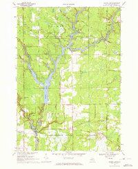 1969 Secord Lake1972 Print · USGSGladwin County's river-fed landscapes are frozen in time here during the late sixties, showcasing the vast reservoir systems of the northern Tittabawassee. Researchers can trace the development of Secord and Bowmanville, or locate specific landmarks like the Secord Ch and the historic Secord Dam.2 unique versions available
 - 1983 Map of Houghton Lake, 1984 Print
 1983 Houghton Lake1984 Print · USGSIn the early 1980s, the Michigan heartland around Houghton Lake was a patchwork of state forest and growing lakeside resorts. Genealogists and historians can trace the development of communities like West Branch and Rose City alongside landmarks like Roscommon County Airfield.
 - 1989 Map of Traverse City, 1990 Print
 1989 Traverse City1990 Print · USGSNorthern Michigan’s lake-country and forest lands are captured in the late eighties as seasonal tourism and timber hubs expanded. Genealogists and historians can trace the routes of the Ann Arbor RR, the boundaries of Camp Grayling, and settlements like Elk Rapids and Manton.
End of results
Showing maps 1-8 of 8
Top cities near Butman Township
- Gladwin historical maps
- Butman historical maps
- West Branch historical maps
- Prudenville historical maps
- Edwards historical maps
- Secord historical maps
Top neighborhoods of Butman Township
Frequently asked questions
- What are the different types of historical maps available for Butman Township?
- What is the oldest map of Butman Township?
- Where can I purchase historical maps of Butman Township for my home or office?
- Where can I download high-res historical maps of Butman Township?
- Are there historical topographic maps available for Butman Township?
- Is there historical aerial imagery available for Butman Township?
- Where are historical maps of Butman Township sourced from?