Old Maps of Wakefield Township, Michigan for Metal Detecting
Plan your next treasure hunt with 77 historic maps of Wakefield Township. Find old homesites, ghost towns, trails, and gathering spots that may be lost to time — perfect for identifying promising metal detecting locations.
- Locate forgotten sites: Uncover places like long-lost settlements, abandoned rail lines, or gathering spots.
- Plan better hunts: Use map overlays combined with LiDAR or satellite views to narrow in on historically rich areas.
- Made for detectorists: Thousands of hobbyists use these maps to discover relics, coins, and hidden history.
Use these historic maps to boost your research and find new opportunities beneath the surface of Wakefield Township.
Wakefield Township, MI maps
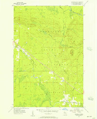
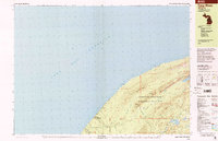
(77)- 1955 Map of Marenisco, 1957 Print
 1955 Marenisco1957 Print · USGSThe Michigan-Wisconsin borderlands and the deep woods of the Upper Peninsula are captured here in the mid-fifties. Genealogists and local historians can trace the rail-and-timber era through Marenisco, the Chicago and North Western line, and fire towers like Copps Lookout Tower.3 unique versions available
 - 1955 Map of Marenisco, 1957 Print
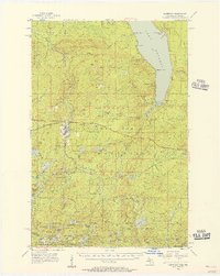
 1955 Marenisco1957 Print · USGSUpper Peninsula timber country and rail history are well-preserved here in the mid-fifties, centered on the logging town of Marenisco. Researchers can trace the Chicago and North Western line, locate the Marenisco Landing Field, or find family-named landmarks like Theilers and Ethelwood.2 unique versions available
 - 1955 Map of Wakefield, 1957 Print
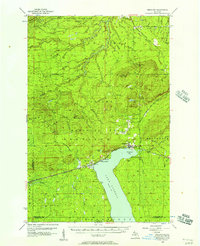
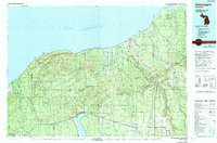
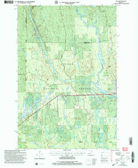
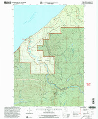
 1955 Wakefield1957 Print · USGSWakefield and the iron-rich Gogebic Range are shown here during the mid-1950s as mining operations shaped the landscape. Genealogists and industrial historians can trace the neighborhoods around Sunday Lake, find the Lakeside Cem, and locate mines like the Sunday Lake Mine.2 unique versions available
 - 1955 Map of Wakefield, 1957 Print
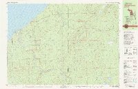
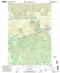
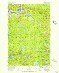 1955 Wakefield1957 Print · USGSThe iron country of the Upper Peninsula is frozen in time during the mid-fifties, showing the industrial core of the Gogebic Range. Genealogists and historians can trace the early layout of Wakefield and its surrounding mining hubs like Ramsay and Verona before the landscape of the Sunday Lake Mine was further altered.3 unique versions available
 - 1955 Map of Wakefield NE, 1957 Print
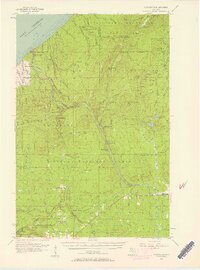
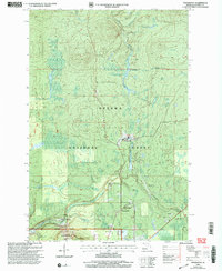
 1955 Wakefield NE1957 Print · USGSUpper Peninsula timberlands and rail corridors are captured in the mid-1950s within the Ottawa National Forest. Researchers can trace the Chicago and North Western line through forest settlements like Hartley and Dunham or locate the peak of Wolf Mountain.2 unique versions available
 - 1956 Map of Carp River, 1957 Print
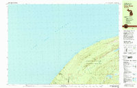
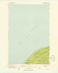 1956 Carp River1957 Print · USGSThe Upper Peninsula shoreline meets the high ridges of the western Gogebic Range in the mid-1950s. Trace old mining sites like the LaFayette Mine and backcountry landmarks including Lake of the Clouds, Mirror Lake, and Lone Rock.4 unique versions available
 - 1956 Map of Bergland, 1957 Print
 1956 Bergland1957 Print · USGSUpper Peninsula timber and copper country come into focus in the mid-fifties as the railroad meets the shores of Lake Gogebic. Researchers can trace the rail sidings near Bergland, the workings of the White Pine Mine, and remote landmarks like Krobath Cabin.3 unique versions available
 - 1956 Map of Thomaston, 1957 Print
 1956 Thomaston1957 Print · USGSThe Upper Peninsula wilderness in the mid-fifties is captured here, showing the heavy industrial influence of the Chicago and North Western railroad. Researchers can trace the timber-era rail sidings at Tula and Manley Siding or locate the Underwood Lookout Tower.4 unique versions available
 - 1958 Map of Iron River, 1968 Print
 1958 Iron River1968 Print · USGSThe Upper Peninsula in the late fifties is captured here as a landscape of timber, iron, and rail. Genealogists and historians can trace rail stops like Mass Station or explore the coastlines of Lake Gogebic and Keweenaw Bay.3 unique versions available
 - 1960 Map of Iron River
 1960 Iron River1960 Print · USGSThe Upper Peninsula’s western reaches are shown in the late fifties, featuring the industrial infrastructure of the Copper Country and the vast Ottawa National Forest. Researchers can trace the rail lines of the Milwaukee Road through settlements like Bruce Crossing and the White Pine Mine.
 - 1961 Map of Iron River
 1961 Iron River1961 Print · USGSThe Upper Peninsula and northern Wisconsin are shown here in the early 1960s, a landscape defined by the iron range and vast timberlands. Researchers can trace the legacy of mining and rail transport through Caspian, the Lac Du Flambeau Indian Reservation, and the Milwaukee Road.
 - 1967 Map of Iron River, 1968 Print
 1967 Iron River1968 Print · USGSThe Upper Peninsula and northern Wisconsin borderlands are shown here in the late sixties, a landscape of deep woods and iron-country rail lines. Genealogists and historians can trace the lakeside settlements of L'Anse and Ontonagon or follow the Soo Line through towns like Michigamme and Nestoria.
 - 1979 Map of Ontonagon, 1991 Print
 1979 Ontonagon1991 Print · USGSThe Western Upper Peninsula coastline and copper country are captured here during the late twentieth century. Genealogists and historians can trace the rail-and-river network connecting settlements like White Pine, Lake Mine, and Bruce Crossing.
 - 1980 Map of Carp River, 1981 Print
 1980 Carp River1981 Print · USGSThe northern wilderness of the Upper Peninsula is documented here in the early eighties, centered on the high ridges above Lake Superior. Trace the footpaths of the Porcupine Mountains to find the Old LaFayette Mine and Lake of the Clouds.2 unique versions available
 - 1980 Map of Tiebel Creek, 1981 Print
 1980 Tiebel Creek1981 Print · USGSThe Upper Peninsula wilderness along Lake Superior is captured here during the early eighties, where the Porcupine Mountains meet the coast. Trace the industrial legacy of the Old Railroad Grade or locate remote landmarks like Summit Peak and Beaver Lake.2 unique versions available
 - 1981 Map of Thomaston
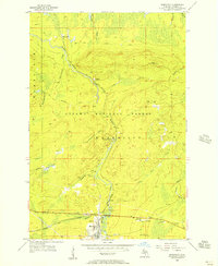
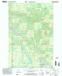
 1981 Thomaston1981 Print · USGSGogebic County in the early eighties shows a landscape of timber management and mining infrastructure. You can trace the path of the Soo Line through settlements like Thomaston and Connorville or locate natural landmarks such as Gabbro Falls and Minnewawa Falls.
 - 1982 Map of Merriweather
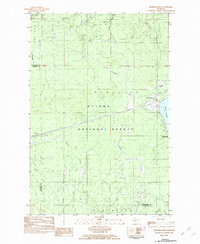 1982 Merriweather1982 Print · USGSThe northern shores of Lake Gogebic are captured here in the early eighties, showcasing the community of Merriweather and its surrounding timberlands. Local historians can trace the lakeside development at Ontonagon County Park and inland features like Haskin Rapid and the Pipeline.
 - 1990 Map of Wakefield
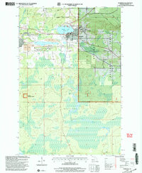
 1990 Wakefield1990 Print · USGSThe Michigan-Wisconsin borderlands are captured here in the late twentieth century, showing the transition from an industrial rail-and-timber hub to a recreation-focused landscape. Trace the Chicago & North Western RR through Marenisco or locate landmarks like Agate Falls and Wakefield.
 - 1994 Map of Carp River, 2000 Print
 1994 Carp River2000 Print · USGSThe Lake Superior shoreline and the high ridges of the Ontonagon wilderness are documented here in the mid-nineties. Researchers can locate remote industrial sites like the Old LaFayette Mine or trace the backcountry paths to Traders Falls and Mirror Lake.
 - 1999 Map of Tula, 2004 Print
 1999 Tula2004 Print · USGSThe Upper Peninsula wilderness comes into focus at the close of the twentieth century, highlighting the dense timberlands and river systems of the western region. Genealogists and researchers can trace local landmarks like Tula, Jack Spur, and the waters of the Presque Isle River.
 - 1999 Map of Merriweather, 2004 Print
 1999 Merriweather2004 Print · USGSThe western shores of Lake Gogebic are captured here in the late 1990s as they transition into the deep woods of the Ottawa National Forest. Researchers can trace the layout of Merriweather, locate a Mobile Home Park near the water, and follow the paths of Pony Creek and Warbler Creek.
 - 1999 Map of Thomaston, 2004 Print
 1999 Thomaston2004 Print · USGSThe Ottawa National Forest in the late nineties is revealed here through its timber and recreational landscapes. Trace local history at Thomaston, Connorville, and the Manley Siding rail point, or explore landmarks like Gabbro Falls and the Indianhead Mountain Ski Area.
 - 1999 Map of Tiebel Creek, 2004 Print
 1999 Tiebel Creek2004 Print · USGSThe Lake Superior shoreline and the deep woods of the Upper Peninsula are captured here in the late nineties. Explore the numerous cascades of the Presque Isle River, including Manabezho Falls and Nokomis Falls, within the Porcupine Mountains State Park.
 - 1999 Map of Wakefield, 2004 Print
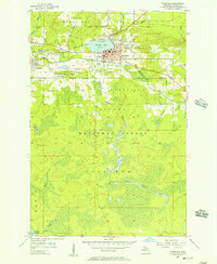
 1999 Wakefield2004 Print · USGSThe Upper Peninsula mining and forest lands of Gogebic County are shown here at the turn of the millennium. Researchers can trace the industrial footprint of the Sunday Lake Mine and locate civic landmarks like City Hall and Lakeside Cem.
 - 1999 Map of Wakefield NE, 2004 Print
 1999 Wakefield NE2004 Print · USGSThe Upper Peninsula timberlands in Gogebic County are shown here at the turn of the millennium within the Ottawa National Forest. Researchers can trace the watercourses of the Presque Isle River and locate the Hide-Away Village Landing Strip and the small settlement of Dunham.
Showing maps 1-25 of 77
Top cities near Wakefield Township
Top neighborhoods of Wakefield Township
- Verona historical maps
- Thomaston historical maps
- Tula historical maps
- Connorville historical maps
- Planter historical maps
Frequently asked questions
- What are the different types of historical maps available for Wakefield Township?
- What is the oldest map of Wakefield Township?
- Where can I purchase historical maps of Wakefield Township for my home or office?
- Where can I download high-res historical maps of Wakefield Township?
- Are there historical topographic maps available for Wakefield Township?
- Is there historical aerial imagery available for Wakefield Township?
- Where are historical maps of Wakefield Township sourced from?