1970s Maps of Emerson Township, Michigan
Explore 4 historic maps of Emerson Township from the 1970s. These maps offer a rare glimpse into what life looked like during the 1970s — showing old roads, neighborhoods, homes, and landmarks that have changed or disappeared over time.
Whether you're researching your family's past, planning a metal detecting trip, or studying how Emerson Township's landscape evolved across the 1970s, these high-resolution maps are a powerful tool for exploring the history of this region.
- Focus on a specific era: All maps on this page are from the 1970s, giving you a focused view of this time period.
- See what’s changed: Compare century-old streets, trails, and buildings to today's modern landscape using overlays and satellite layers.
- Research with precision: Use these maps for genealogy, historical research, land use analysis, or educational projects.
- View, download, or print: Maps are fully viewable online in high resolution, and can be downloaded or printed for your own records.
Start exploring Emerson Township's history through authentic maps from the 1970s. This is your window into the past.
Emerson Township, MI maps
(4)- 1973 Map of Ithaca, 1976 Print
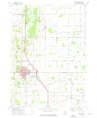 1973 Ithaca1976 Print · USGSIthaca and the surrounding townships of Emerson and Newark are shown in the early seventies as a mature agricultural hub. Researchers can locate family landmarks like Beebe Cem, Herron Sch, and the Dodge Sett amidst the local stream network.
 - 1973 Map of St. Louis, 1977 Print
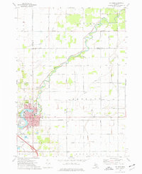 1973 St. Louis1977 Print · USGSMid-century St. Louis and the surrounding farm country are captured here during a period of steady industrial and civic activity. Genealogists and local historians can trace family locations near the Bethany Indian Cem, Oak Grove Cemetery, or the numerous local schools like Westgate Sch.
 - 1973 Map of Rathbone, 1977 Print
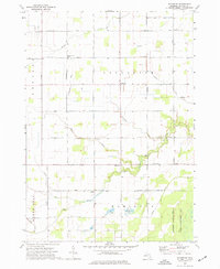 1973 Rathbone1977 Print · USGSGratiot County is shown in the early seventies as a thriving agricultural landscape defined by small crossroads settlements and a dense network of country roads. Researchers can trace rural lineages through sites like Lafayette Cem, Hamilton Cem, and the Migrant Workers Camp near Rathbone.
 - 1973 Map of Breckenridge, 1977 Print
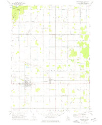 1973 Breckenridge1977 Print · USGSBreckenridge and Wheeler are shown in detail during the early 1970s, as the local economy balanced farming with oil and rail transit. Genealogists and researchers can locate Rose Lawn Cem, Migrant Workers Camp, and the Porter Oil Field.
End of results
Showing maps 1-4 of 4
Top cities near Emerson Township
- Alma historical maps
- Saint Louis historical maps
- Ithaca historical maps
- Wheeler historical maps
- Coe historical maps
- Shepherd historical maps
See more
Top neighborhoods of Emerson Township
Frequently asked questions
- What are the different types of historical maps available for Emerson Township?
- What is the oldest map of Emerson Township?
- Where can I purchase historical maps of Emerson Township for my home or office?
- Where can I download high-res historical maps of Emerson Township?
- Are there historical topographic maps available for Emerson Township?
- Is there historical aerial imagery available for Emerson Township?
- Where are historical maps of Emerson Township sourced from?