1970s Maps of Sumner Township, Michigan
Explore 2 historic maps of Sumner Township from the 1970s. These maps offer a rare glimpse into what life looked like during the 1970s — showing old roads, neighborhoods, homes, and landmarks that have changed or disappeared over time.
Whether you're researching your family's past, planning a metal detecting trip, or studying how Sumner Township's landscape evolved across the 1970s, these high-resolution maps are a powerful tool for exploring the history of this region.
- Focus on a specific era: All maps on this page are from the 1970s, giving you a focused view of this time period.
- See what’s changed: Compare century-old streets, trails, and buildings to today's modern landscape using overlays and satellite layers.
- Research with precision: Use these maps for genealogy, historical research, land use analysis, or educational projects.
- View, download, or print: Maps are fully viewable online in high resolution, and can be downloaded or printed for your own records.
Start exploring Sumner Township's history through authentic maps from the 1970s. This is your window into the past.
Sumner Township, MI maps
(2)- 1973 Map of Alma South, 1976 Print
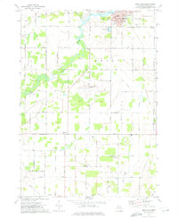 1973 Alma South1976 Print · USGSThe Gratiot County countryside south of Alma comes into focus in the early 1970s, showcasing a landscape of section-line roads and family-named landmarks. Genealogists can trace sites like Pritchard Cem, Newark Ch, and the Migrant Workers Camp.
 - 1973 Map of Alma North, 1976 Print
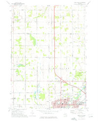 1973 Alma North1976 Print · USGSGratiot County's agricultural and academic heart comes into focus in the early 1970s as Alma and St Louis continue their growth along the Pine River. Genealogists and local historians can locate long-standing rural landmarks like Brady Cem, St Johns Ch, and the outlying village of Elwell.
End of results
Showing maps 1-2 of 2
Top cities near Sumner Township
- Alma historical maps
- Saint Louis historical maps
- Crystal historical maps
- Ithaca historical maps
- Coe historical maps
- Sumner historical maps
See more
Top neighborhoods of Sumner Township
Frequently asked questions
- What are the different types of historical maps available for Sumner Township?
- What is the oldest map of Sumner Township?
- Where can I purchase historical maps of Sumner Township for my home or office?
- Where can I download high-res historical maps of Sumner Township?
- Are there historical topographic maps available for Sumner Township?
- Is there historical aerial imagery available for Sumner Township?
- Where are historical maps of Sumner Township sourced from?