1990s Maps of Camden Township, Michigan
Explore 3 historic maps of Camden Township from the 1990s. These maps offer a rare glimpse into what life looked like during the 1990s — showing old roads, neighborhoods, homes, and landmarks that have changed or disappeared over time.
Whether you're researching your family's past, planning a metal detecting trip, or studying how Camden Township's landscape evolved across the 1990s, these high-resolution maps are a powerful tool for exploring the history of this region.
- Focus on a specific era: All maps on this page are from the 1990s, giving you a focused view of this time period.
- See what’s changed: Compare century-old streets, trails, and buildings to today's modern landscape using overlays and satellite layers.
- Research with precision: Use these maps for genealogy, historical research, land use analysis, or educational projects.
- View, download, or print: Maps are fully viewable online in high resolution, and can be downloaded or printed for your own records.
Start exploring Camden Township's history through authentic maps from the 1990s. This is your window into the past.
Camden Township, MI maps
(3)- 1990 Map of Adrian, 1991 Print
 1990 Adrian1991 Print · USGSThe Michigan and Ohio borderlands come alive in the final decade of the twentieth century, showing the intricate network of glacial lakes and small-town junctions. Genealogists and local researchers can pinpoint family landmarks from Lakeview Cem to the rail sidings of the Conrail and Norfolk Southern lines.
 - 1992 Map of Clear Lake, 1995 Print
 1992 Clear Lake1995 Print · USGSThe tri-state border region of Indiana, Michigan, and Ohio is captured here as it appeared in the late twentieth century. Researchers can trace family sites like Teeters Cem and Rogers Cem or locate community hubs such as Billingstown and Clear Lake Ch.
 - 1992 Map of Camden, 1995 Print
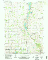 1992 Camden1995 Print · USGSThe Michigan-Indiana border comes alive in the 1990s as it appeared before modern development altered these rural township landscapes. Researchers can locate family landmarks like Gleason Cem, the West Reading Ch, and numerous named lakes from Loon Lake to Mead Lake.
End of results
Showing maps 1-3 of 3
Top cities near Camden Township
- Coldwater historical maps
- Angola historical maps
- Hillsdale historical maps
- Montpelier historical maps
- Cambria historical maps
- Jonesville historical maps
See more
Top neighborhoods of Camden Township
Frequently asked questions
- What are the different types of historical maps available for Camden Township?
- What is the oldest map of Camden Township?
- Where can I purchase historical maps of Camden Township for my home or office?
- Where can I download high-res historical maps of Camden Township?
- Are there historical topographic maps available for Camden Township?
- Is there historical aerial imagery available for Camden Township?
- Where are historical maps of Camden Township sourced from?