1940s Maps of Camden, Camden Township
Explore 2 historic maps of Camden from the 1940s. These maps offer a rare glimpse into what life looked like during the 1940s — showing old roads, neighborhoods, homes, and landmarks that have changed or disappeared over time.
Whether you're researching your family's past, planning a metal detecting trip, or studying how Camden's landscape evolved across the 1940s, these high-resolution maps are a powerful tool for exploring the history of this region.
- Focus on a specific era: All maps on this page are from the 1940s, giving you a focused view of this time period.
- See what’s changed: Compare century-old streets, trails, and buildings to today's modern landscape using overlays and satellite layers.
- Research with precision: Use these maps for genealogy, historical research, land use analysis, or educational projects.
- View, download, or print: Maps are fully viewable online in high resolution, and can be downloaded or printed for your own records.
Start exploring Camden's history through authentic maps from the 1940s. This is your window into the past.
Camden, Camden Township maps
(2)- 1940 Map of Clear Lake
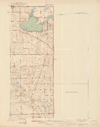 1940 Clear Lake1940 Print · USGSThe tri-state border region of Indiana, Michigan, and Ohio is captured here just before the 1940s, centered on the activity surrounding Clear Lake. Researchers can trace early school sites and family landmarks like Powers Sch, Stallman Bridge, and the Teeters Cem.2 unique versions available
 - 1944 Map of Pioneer
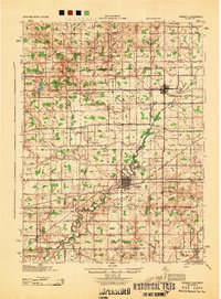 1944 Pioneer1944 Print · USGSWilliams County and the Michigan border are captured here during the mid-forties, showing a landscape of small farming hamlets and district schools. Researchers can trace the path of the Wabash railroad through Montpelier or locate family sites near Nettle Lake and the County Infirmary.
End of results
Showing maps 1-2 of 2
Top cities near Camden
- Coldwater historical maps
- Angola historical maps
- Hillsdale historical maps
- Montpelier historical maps
- Cambria historical maps
- Jonesville historical maps
See more
Frequently asked questions
- What are the different types of historical maps available for Camden?
- What is the oldest map of Camden?
- Where can I purchase historical maps of Camden for my home or office?
- Where can I download high-res historical maps of Camden?
- Are there historical topographic maps available for Camden?
- Is there historical aerial imagery available for Camden?
- Where are historical maps of Camden sourced from?