
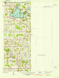
1940 Map of Clear Lake
USGS Topo · Published 1940About this map
Clear Lake and its surrounding glacial kettle lakes anchor this 1938 survey of the tri-state corner where Indiana, Ohio, and Michigan meet. The landscape is defined by its complex hydrology, featuring numerous smaller bodies of water like Mirror Lake, Lake Anne, and Handy Lake, alongside significant wetlands such as Barnes Swamp and Big Swamp. The settlement patterns of the late 1930s are clearly visible, from the established village of Ray in the northwest to crossroads like York and Courtney Corner. Local infrastructure and social centers are well-documented, including the Clear Lake Ch, Powers Sch, and several family and community burial grounds such as Covenant Cem and Dygert Cem. Transportation routes of the era, including the historic Vestula Road and Highway No 20, facilitate travel across the multi-state boundary, while drainage systems like the Bruce Ryan Ditch reveal the agricultural management of the region's low-lying terrain.
Find a feature on this map
34 named features on this map. Tap any name to fly to it.
Don’t see what you’re looking for? This feature index may not catch every label — zoom into the map to look around manually.
Map Details
Editions of this 1940 Clear Lake Map
2 editions found
Other maps of this area

1914 · Pioneer
USGS Topo · 1:62,500

1939 · Hamilton
USGS Topo · 1:24,000

1939 · Angola East
USGS Topo · 1:24,000

1939 · Clear Lake
USGS Topo · 1:24,000

1940 · Metz
USGS Topo · 1:24,000

1944 · Pioneer
USGS Topo · 1:62,500

1947 · Angola East
USGS Topo · 1:24,000

1948 · Hamilton
USGS Topo · 1:24,000

1953 · Fort Wayne
USGS Topo · 1:250,000

1956 · Fort Wayne
USGS Topo · 1:250,000