1970s Maps of Calumet Township, Michigan
Explore 4 historic maps of Calumet Township from the 1970s. These maps offer a rare glimpse into what life looked like during the 1970s — showing old roads, neighborhoods, homes, and landmarks that have changed or disappeared over time.
Whether you're researching your family's past, planning a metal detecting trip, or studying how Calumet Township's landscape evolved across the 1970s, these high-resolution maps are a powerful tool for exploring the history of this region.
- Focus on a specific era: All maps on this page are from the 1970s, giving you a focused view of this time period.
- See what’s changed: Compare century-old streets, trails, and buildings to today's modern landscape using overlays and satellite layers.
- Research with precision: Use these maps for genealogy, historical research, land use analysis, or educational projects.
- View, download, or print: Maps are fully viewable online in high resolution, and can be downloaded or printed for your own records.
Start exploring Calumet Township's history through authentic maps from the 1970s. This is your window into the past.
Calumet Township, MI maps
(4)- 1978 Map of Muggun Creek
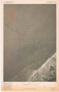 1978 Muggun Creek1978 Print · USGSThe northern shore of Michigan's Upper Peninsula meets the deep waters of Lake Superior in the late 1970s. Trace the coastal mouth of Muggun Creek and examine land lines from a previous 1946 survey.
 - 1978 Map of Mohawk
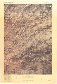 1978 Mohawk1978 Print · USGSUpper Peninsula mining history comes into focus in the late 1970s as aerial photography reveals the layout of these Keweenaw copper country towns. Genealogists and historians can trace the clearings and homes around Mohawk and Fulton in their late twentieth-century context.
 - 1978 Map of Laurium, 1980 Print
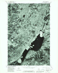 1978 Laurium1980 Print · USGSThe Keweenaw Peninsula’s copper-mining heartland is seen in detail during the late 1970s, from the upland streets of Calumet to the industrial shores of Torch Lake. Genealogists and historians can trace the property lines and neighborhoods of Laurium, Lake Linden, and the lakeside community of Mason.
 - 1978 Map of Hancock, 1980 Print
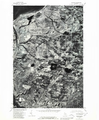 1978 Hancock1980 Print · USGSThe Keweenaw Peninsula is captured in the late seventies, showing the industrial and residential heart of Hancock along the water. Trace the path of the Portage Lake Ship Canal and locate rural crossroads like Paavola and Boston.
End of results
Showing maps 1-4 of 4
Top cities near Calumet Township
- Houghton historical maps
- Hancock historical maps
- Laurium historical maps
- Osceola historical maps
- Chassell historical maps
- Allouez historical maps
See more
Top neighborhoods of Calumet Township
- Centennial Heights historical maps
- Kearsarge historical maps
- Lakeview historical maps
- Phillipsville historical maps
- Wolverine historical maps
- Swedetown historical maps
See more
Frequently asked questions
- What are the different types of historical maps available for Calumet Township?
- What is the oldest map of Calumet Township?
- Where can I purchase historical maps of Calumet Township for my home or office?
- Where can I download high-res historical maps of Calumet Township?
- Are there historical topographic maps available for Calumet Township?
- Is there historical aerial imagery available for Calumet Township?
- Where are historical maps of Calumet Township sourced from?