1980s Maps of Huron County, Michigan
Explore 4 historic maps of Huron County from the 1980s. These maps offer a rare glimpse into what life looked like during the 1980s — showing old roads, neighborhoods, homes, and landmarks that have changed or disappeared over time.
Whether you're researching your family's past, planning a metal detecting trip, or studying how Huron County's landscape evolved across the 1980s, these high-resolution maps are a powerful tool for exploring the history of this region.
- Focus on a specific era: All maps on this page are from the 1980s, giving you a focused view of this time period.
- See what’s changed: Compare century-old streets, trails, and buildings to today's modern landscape using overlays and satellite layers.
- Research with precision: Use these maps for genealogy, historical research, land use analysis, or educational projects.
- View, download, or print: Maps are fully viewable online in high resolution, and can be downloaded or printed for your own records.
Start exploring Huron County's history through authentic maps from the 1980s. This is your window into the past.
Huron County, MI maps
(4)- 1984 Map of Harbor Beach, 1985 Print
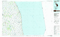 1984 Harbor Beach1985 Print · USGSCoastal Huron and Sanilac counties come into focus in the mid-1980s, showcasing the region's transition from shoreline industry to interior agriculture. Genealogists can trace family names through landmarks like Hallway Corners and small communities such as Bad Axe, Parisville, and Minden City.2 unique versions available
 - 1984 Map of Pointe Aux Barques, 1985 Print
 1984 Pointe Aux Barques1985 Print · USGSThe northern tip of Michigan's thumb is captured in the mid-eighties as a landscape of remote coastal outposts and Great Lakes maritime borders. Researchers can trace the industrial legacy of Grind Stone City and its Quarries or the small-town layouts of Port Austin and Huron City.2 unique versions available
 - 1984 Map of Tawas City, 1985 Print
 1984 Tawas City1985 Print · USGSNortheast Michigan's shoreline and forest interior are captured here in the mid-eighties, from the active runways of Wurtsmith Air Force Base to the quiet waters of Tawas Bay. Genealogists and local historians can locate rural landmarks like Skunk Sch, the Welcome Church, and the route of the Detroit and Mackinac railroad.3 unique versions available
 - 1984 Map of Bay City, 1985 Print
 1984 Bay City1985 Print · USGSSaginaw Bay and the surrounding Michigan thumb region are captured in the mid-1980s, showing a landscape defined by industrial riverfronts and expanding lakeside parks. Researchers can trace family roots through landmarks like Floral Gardens Cem or follow the Chesapeake and Ohio rail lines through towns like Bad Axe and Pigeon.
End of results
Showing maps 1-4 of 4
Top cities of Huron County
Frequently asked questions
- What are the different types of historical maps available for Huron County?
- What is the oldest map of Huron County?
- Where can I purchase historical maps of Huron County for my home or office?
- Where can I download high-res historical maps of Huron County?
- Are there historical topographic maps available for Huron County?
- Is there historical aerial imagery available for Huron County?
- Where are historical maps of Huron County sourced from?