1900s (20th Century) Maps of Huron County, Michigan
Explore 33 historic maps of Huron County from the 1900s (20th Century). These maps offer a rare glimpse into what life looked like during the 1900s — showing old roads, neighborhoods, homes, and landmarks that have changed or disappeared over time.
Whether you're researching your family's past, planning a metal detecting trip, or studying how Huron County's landscape evolved across the 1900s, these high-resolution maps are a powerful tool for exploring the history of this region.
- Focus on a specific era: All maps on this page are from the 1900s, giving you a focused view of this time period.
- See what’s changed: Compare century-old streets, trails, and buildings to today's modern landscape using overlays and satellite layers.
- Research with precision: Use these maps for genealogy, historical research, land use analysis, or educational projects.
- View, download, or print: Maps are fully viewable online in high resolution, and can be downloaded or printed for your own records.
Start exploring Huron County's history through authentic maps from the 1900s. This is your window into the past.
Huron County, MI maps
(33)- 1954 Map of Flint, 1968 Print
 1954 Flint1968 Print · USGSThe industrial corridor and fertile Thumb region of Michigan come alive in this mid-century survey. Genealogists and historians can trace the rail networks of the Grand Trunk, locate established settlements like Bad Axe and Sandusky, or explore the 1950s shoreline along Saginaw Bay.4 unique versions available
 - 1954 Map of Tawas City, 1968 Print
 1954 Tawas City1968 Print · USGSCoastal life along Lake Huron was defined by a mix of military aviation and hydroelectric power in the mid-fifties. Researchers can trace the river dams like Cooke Dam, the layout of Wurtsmith AFB, and the coastal mining operations at Alabaster.4 unique versions available
 - 1958 Map of Flint
 1958 Flint1958 Print · USGSThe Michigan Thumb and the Saginaw Valley are captured here during the height of the post-war industrial era. Researchers can trace the complex rail networks of the Grand Trunk Western or locate mid-century landmarks like Lakeport State Park and the port at Bay City.2 unique versions available
 - 1958 Map of Tawas City
 1958 Tawas City1958 Print · USGSThe Lake Huron shoreline and northern Michigan timberlands come into focus in the late fifties, during the expansion of the Cold War. Genealogists and historians can trace rail lines like the Detroit and Mackinac, find regional landmarks like the Lumbermans Memorial Monument, and locate coastal facilities including Wurtsmith AFB.2 unique versions available
 - 1963 Map of Forestville, 1964 Print
 1963 Forestville1964 Print · USGSThe Lake Huron shoreline in the early sixties shows a landscape of small coastal settlements and family farms. Researchers can trace landownership through family-named routes like Potts Road and Munford Road, or locate ancestors at White Rock Cem.2 unique versions available
 - 1963 Map of Ruth, 1964 Print
 1963 Ruth1964 Print · USGSAgricultural life in the Michigan Thumb is documented here during the early sixties, centered on the village of Ruth. Researchers can trace the Chesapeake and Ohio rail line and locate rural landmarks like SS Peter and Paul Cem and Charleston.2 unique versions available
 - 1963 Map of New Greenleaf, 1964 Print
 1963 New Greenleaf1964 Print · USGSAgricultural life in Michigan's Thumb is captured here during the early sixties, as drainage and rail networks sustained the rural economy. Genealogists can locate family landmarks like McTaggart Cemetery, the Stoner School, and St Columbkille Church.
 - 1963 Map of Ubly, 1964 Print
 1963 Ubly1964 Print · USGSHuron and Sanilac counties are captured here in the early sixties, showing a landscape defined by rail-side commerce and an extensive network of field drains. Genealogists and local historians can trace family-named landmarks such as Valley Cem, Bingham Sch, and the village of Tyre.
 - 1963 Map of Minden City, 1964 Print
 1963 Minden City1964 Print · USGSMinden City and Parisville sit at the center of this 1960s agricultural survey on the Sanilac and Huron county line. Local researchers can trace family landmarks like St Patricks Ch, the Palms Sch, and the unique industrial Peat Bog near Peatville.
 - 1963 Map of Gagetown, 1964 Print
 1963 Gagetown1964 Print · USGSThe borderlands of Tuscola and Huron counties are captured here in the early sixties, showing a landscape of productive farmland and small rail towns. Genealogists can trace family names through landmarks like Grant Cem, Canboro Sch, and the Grand Trunk Western RR station in Gagetown.
 - 1963 Map of Owendale, 1964 Print
 1963 Owendale1964 Print · USGSThe Michigan Thumb’s rural heartland is captured in the early sixties as a structured grid of farmsteads and drainage canals. Researchers can trace family ties and township history through landmarks like Owendale, St Peters Sch, and the New York Central rail line.
 - 1963 Map of Sebewaing, 1965 Print
 1963 Sebewaing1965 Print · USGSThe Saginaw Bay shoreline and the Thumb's fertile farm country are captured here in the early sixties. Genealogists and local historians can trace the rail lines of the Chesapeake and Ohio and locate landmarks like New Salem Cem and Unionville.2 unique versions available
 - 1970 Map of Bay Port West, 1972 Print
 1970 Bay Port West1972 Print · USGSCoastal Huron County in the early seventies shows a landscape defined by the intricate wetlands of Wildfowl Bay and the Saginaw Bay shoreline. Genealogists and local historians can trace family roads and rural landmarks like Fairhaven Ch, Bay Port Cem, and the tracks of the Chesapeake and Ohio.2 unique versions available
 - 1970 Map of Bay Port East, 1972 Print
 1970 Bay Port East1972 Print · USGSThe fertile plains of Huron County appear here in the early 1970s, defined by the Pigeon River and the lakefront at Wildfowl Bay. Researchers can trace family roots at Kilmanagh Ch or locate the old Quarry and Linkville cemetery.
 - 1970 Map of Caseville, 1972 Print
 1970 Caseville1972 Print · USGSThe Lake Huron shoreline at Caseville is meticulously documented here during the early 1970s. Trace the coastal growth from Oak Point down to Wildfowl Bay, locating local landmarks like Caseville Cem and St Johns Ch.
 - 1970 Map of Rush Lake, 1972 Print
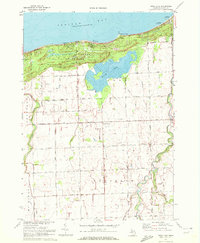 1970 Rush Lake1972 Print · USGSThe northern tip of Michigan's Thumb is captured here in 1970, showing the coastal dunes and agricultural interior. Trace local genealogy and landmarks at Gotts Corners, St Felix Cem, and the Drive-in Theater near Rush Lake.
 - 1970 Map of Port Hope, 1973 Print
 1970 Port Hope1973 Print · USGSThe tip of Michigan's Thumb comes alive in the early seventies, centered on the village of Port Hope along the Lake Huron shore. Genealogists and historians can trace family plots at Gore Cem or follow the old Chesapeake and Ohio rail line.
 - 1970 Map of Port Austin East, 1973 Print
 1970 Port Austin East1973 Print · USGSThe tip of Michigan's Thumb comes into focus in the 1970s, showcasing the coastal settlements and maritime landscape of Huron County. Genealogists and researchers can locate Port Austin Cemetery, trace the Chesapeake and Ohio rail line, and find old shoreline quarries near Grind Stone City.2 unique versions available
 - 1970 Map of Kinde East, 1973 Print
 1970 Kinde East1973 Print · USGSHuron County's northern agricultural heartland is documented here in the late sixties, centered on the rail-line settlements of Kinde and Filion. Researchers can trace local history through family-named landmarks and institutions like St Marys Cem, Church Sch, and the Townhall.
 - 1970 Map of Redman, 1973 Print
 1970 Redman1973 Print · USGSHuron County's agricultural heartland met the Great Lakes shoreline during the early seventies, organized by a rigid grid of family-named roads. Genealogists and local historians can locate the Red School, Marquardt Cemetery, and the community of Lewisville.
 - 1970 Map of Huron City, 1973 Print
 1970 Huron City1973 Print · USGSThe northern tip of Michigan's Thumb is captured here in the early seventies, showing the coastal transition from farming to recreation. Trace local family history at New River Cem or explore the shoreline near Huron City and Lighthouse County Park.
 - 1970 Map of Harbor Beach, 1973 Print
 1970 Harbor Beach1973 Print · USGSThe Lake Huron shoreline comes alive in this 1970s survey of the Huron County coast during a period of steady maritime and agricultural activity. Researchers can trace family roots through sites like Rock Falls Cem, the Wade Sch, and the inland rail stop at Helena.2 unique versions available
 - 1970 Map of Sand Point, 1973 Print
 1970 Sand Point1973 Print · USGSThe Lake Huron shoreline comes into focus in the early 1970s as seasonal developments expand along Sand Point. Researchers can trace the layout of Crescent Beach and the isolated geography of North Island in Wildfowl Bay.
 - 1970 Map of Port Austin West, 1973 Print
 1970 Port Austin West1973 Print · USGSThe northern tip of Huron County is shown during the early 1970s, where the Saginaw Bay shoreline meets the open lake. Genealogists and local historians can trace the Port Crescent Cem and the Cold War era Port Austin Air Force Station.
 - 1970 Map of Kinde West, 1973 Print
 1970 Kinde West1973 Print · USGSHuron County's northern farmlands and coastal dunes meet in the 1970s, showing the settled landscape of the Michigan Thumb. Local historians can trace the Chesapeake and Ohio rail line into Kinde or locate rural landmarks like St Felix Ch and Townhall.
Showing maps 1-25 of 33
Top cities of Huron County
Frequently asked questions
- What are the different types of historical maps available for Huron County?
- What is the oldest map of Huron County?
- Where can I purchase historical maps of Huron County for my home or office?
- Where can I download high-res historical maps of Huron County?
- Are there historical topographic maps available for Huron County?
- Is there historical aerial imagery available for Huron County?
- Where are historical maps of Huron County sourced from?