1970s Maps of Chandler Township, Michigan
Explore 4 historic maps of Chandler Township from the 1970s. These maps offer a rare glimpse into what life looked like during the 1970s — showing old roads, neighborhoods, homes, and landmarks that have changed or disappeared over time.
Whether you're researching your family's past, planning a metal detecting trip, or studying how Chandler Township's landscape evolved across the 1970s, these high-resolution maps are a powerful tool for exploring the history of this region.
- Focus on a specific era: All maps on this page are from the 1970s, giving you a focused view of this time period.
- See what’s changed: Compare century-old streets, trails, and buildings to today's modern landscape using overlays and satellite layers.
- Research with precision: Use these maps for genealogy, historical research, land use analysis, or educational projects.
- View, download, or print: Maps are fully viewable online in high resolution, and can be downloaded or printed for your own records.
Start exploring Chandler Township's history through authentic maps from the 1970s. This is your window into the past.
Chandler Township, MI maps
(4)- 1970 Map of Rush Lake, 1972 Print
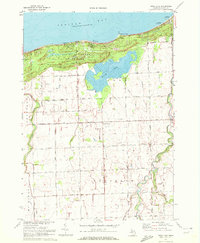 1970 Rush Lake1972 Print · USGSThe northern tip of Michigan's Thumb is captured here in 1970, showing the coastal dunes and agricultural interior. Trace local genealogy and landmarks at Gotts Corners, St Felix Cem, and the Drive-in Theater near Rush Lake.
 - 1970 Map of Kinde West, 1973 Print
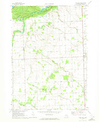 1970 Kinde West1973 Print · USGSHuron County's northern farmlands and coastal dunes meet in the 1970s, showing the settled landscape of the Michigan Thumb. Local historians can trace the Chesapeake and Ohio rail line into Kinde or locate rural landmarks like St Felix Ch and Townhall.
 - 1970 Map of Bad Axe West, 1973 Print
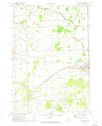 1970 Bad Axe West1973 Print · USGSHuron County's agricultural heartland is documented here during the early 1970s as the rail and road network centered on Bad Axe supported the surrounding townships. Genealogists and researchers can trace the locations of McKenzie Sch, the County Fairground, and Grassmere Station.
 - 1970 Map of Elkton, 1973 Print
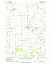 1970 Elkton1973 Print · USGSHuron County's agricultural heartland is documented here during the early seventies, centered on the village of Elkton. Genealogists and local historians can locate family landmarks such as Riverside Cem, the Elkton Ch, and the Steinman Landing Field.
End of results
Showing maps 1-4 of 4
Top cities near Chandler Township
- Bad Axe historical maps
- Pigeon historical maps
- Caseville historical maps
- Elkton historical maps
- Port Austin historical maps
- Kinde historical maps
See more
Frequently asked questions
- What are the different types of historical maps available for Chandler Township?
- What is the oldest map of Chandler Township?
- Where can I purchase historical maps of Chandler Township for my home or office?
- Where can I download high-res historical maps of Chandler Township?
- Are there historical topographic maps available for Chandler Township?
- Is there historical aerial imagery available for Chandler Township?
- Where are historical maps of Chandler Township sourced from?