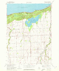
1970 Map of Rush Lake
USGS Topo · Published 1972About this map
Saginaw Bay defines the northern edge of this Huron County shoreline, where the massive Sand Hills of the Albert E Sleeper State Park meet the water. Inland from the coastal dunes, the map reveals a landscape heavily shaped by water management, with the Pinnebog River and Pigeon River winding through the townships of Caseville, Mc Kinley, and Chandler. The namesake Rush Lake sits at the center of this coastal wetland system, flanked by a network of drainage infrastructure like the Etzler Drain and Limerick Drain.
Find a feature on this map
47 named features on this map. Tap any name to fly to it.
Don’t see what you’re looking for? This feature index may not catch every label — zoom into the map to look around manually.
Map Details
Editions of this 1970 Rush Lake Map
This is the sole edition of this map. No revisions or reprints were ever made.
Other maps of this area

1954 · Flint
USGS Topo · 1:250,000

1954 · Tawas City
USGS Topo · 1:250,000

1958 · Flint
USGS Topo · 1:250,000

1958 · Tawas City
USGS Topo · 1:250,000

1970 · Bay Port East
USGS Topo · 1:24,000

1970 · Caseville
USGS Topo · 1:24,000

1970 · Port Austin West
USGS Topo · 1:24,000

1970 · Kinde West
USGS Topo · 1:24,000

1970 · Bad Axe West
USGS Topo · 1:24,000
1970 · Elkton
USGS Topo · 1:24,000